Tornado watch vs. tornado warning
A tornado watch means the ingredients for tornadoes are present over a large area for the next several hours. A tornado warning means a tornado is happening, or is about to, in a small area, right now. The two products come from different offices, cover different areas, last different lengths of time and ask different things of you. This article sets out exactly what each one is, the levels above and below them, how they reach you, how the system was built, and how well it works.

- Watch: tornadoes are possible. Issued by the Storm Prediction Center in Norman, Oklahoma, for tens of thousands of square miles and several hours. Review your plan and keep watching the sky and the alerts.
- Warning: a tornado has been sighted or indicated by radar. Issued by your local National Weather Service office for a polygon a few counties across, usually for 15 to 45 minutes. Take shelter immediately.
- Above the warning: a warning tagged "considerable" carries the words "particularly dangerous situation," and one tagged "catastrophic" is headed "tornado emergency." Below the watch sit the convective outlooks, days ahead, in five risk categories.
The short answer
The National Weather Service defines the two products in one sentence each. A tornado watch: "Tornadoes are possible in and near the watch area." A tornado warning: "A tornado has been sighted or indicated by weather radar. There is imminent danger to life and property."[1] Everything else in this article is detail on those two sentences.
Tornado watch Be prepared
- Meaning
- Conditions are favorable for tornadoes. None has to exist yet.
- Issued by
- The Storm Prediction Center, one national office in Norman, Oklahoma.
- Area
- Large: typically 20,000 to 40,000 square miles, many counties or parts of several states.
- Duration
- Hours. SPC describes a typical watch as lasting six to eight hours.
- What to do
- Review your plan, check your shelter and supplies, and be ready to act quickly if a warning follows.
Tornado warning Take action
- Meaning
- A tornado is occurring or imminent, seen by a spotter or indicated by radar.
- Issued by
- The local NWS Weather Forecast Office, one of 122 across the country.[29]
- Area
- Small: a polygon drawn around one storm's expected path, around the size of a city or small county.
- Duration
- Minutes. The directive sets 15 to 45 minutes from issuance.
- What to do
- Move to an interior room on the lowest floor of a sturdy building, away from windows. Leave mobile homes and vehicles for substantial shelter.
The advice under each is the NWS's own. Under a watch: "Review and discuss your emergency plans," "take inventory of your supplies and check your safe room," and "Be ready to act quickly if a warning is issued or you suspect a tornado is approaching." Under a warning: "Move to an interior room on the lowest floor of a sturdy building," "Avoid windows," and "If in a mobile home, a vehicle, or outdoors, move to the closest substantial shelter and protect yourself from flying debris."[1]
Tacos
The analogy that has done more than any official graphic to fix the difference in people's minds was posted by a fire department. On May 3, 2021, Matt Swaney, the communications director of the Normal, Illinois fire department, put it on the department's Facebook page: a tornado watch means "all the ingredients to make tacos readily available"; a tornado warning means "We are having tacos. Right now." The post was shared more than 6,000 times and two TikTok versions passed 150,000 views each. "We did one last year with cupcakes," Swaney told WGLT that July, "but apparently people like tacos a lot more."[2] Weather offices and newsrooms have repeated it every spring since.

The analogy holds up better than most. A watch is issued when a forecaster judges that the ingredients are coming together over a region; whether any storm actually produces a tornado, and where, is not yet knowable. A warning is issued for one storm, when a radar or a spotter says the tornado is there or about to be. The only thing the tacos leave out is that a warning does not need a watch to precede it. The NWS glossary is explicit that a tornado warning "can be issued without a Tornado Watch being already in effect."[3]
The ladder of products
Watches and warnings are the middle two rungs of a ladder that runs from a week out to the next few minutes. Each step down covers a smaller area, a shorter time, and a more specific threat.
Convective outlooks
The Storm Prediction Center issues a Day 1 outlook five times a day, a Day 2 and a Day 3 outlook once each, and a combined Day 4 to 8 outlook every morning.[5][6] Each outlook is a set of probabilities: the chance of a tornado within 25 miles of any point in the shaded area. The public map converts those probabilities into five categories, "1-MRGL-dark green, 2-SLGT-yellow, 3-ENH-orange, 4-MDT-red, and 5-HIGH-magenta," below a sixth, plain thunderstorm, level.[5] A hatched area marks "a 10% (or greater) chance of tornadoes that could produce EF2 or greater damage."[6] The conversion for the tornado probabilities, from the directive that governs the product, is:
| Category | Tornado probability within 25 miles of a point | Reads as |
|---|---|---|
| Marginal | 2% | Isolated severe storms possible |
| Slight | 5% | Organized severe storms expected, low coverage |
| Enhanced | 10%, or 15% unhatched | Greater concentration of severe storms |
| Moderate | 15% hatched, or 30% | Strong tornadoes possible; a public severe weather outlook is issued |
| High | 30% hatched, or 45% and above | An outbreak of tornadoes is expected; issued a few times a year at most |
The thresholds are from Table 3 of NWS Instruction 10-512, read from the directive's text layer.[6] On the afternoon of the Greenfield, Iowa tornado the outlook was Moderate, with a 15 percent hatched tornado probability. An outlook is not a watch. It is the forecast that tells the local offices and the emergency managers what kind of day to staff for.
Mesoscale discussions
Between the outlook and the watch sits a product most people never see. "SPC often issues a Mesoscale Discussion (MCD) statement anywhere from roughly half an hour to several hours before issuing a weather watch," describing what is happening, what is expected, the reasoning, and when and where a watch is likely.[3] Broadcast meteorologists read them; the public usually hears the result as "a watch is likely to be issued shortly."
The watch, in detail
"When conditions become favorable for organized severe thunderstorms or tornadoes to develop, the SPC issues a Severe Thunderstorm or Tornado Watch."[7] The distinction between the two is a matter of the threat expected. A severe thunderstorm watch is for "organized thunderstorms forecast to produce six or more hail events of one inch (quarter-size) diameter and/or greater or convective damaging winds of 50 knots (58 mph) or greater." A tornado watch is for "organized thunderstorms forecast to produce two or more tornadoes or any tornado which could produce EF2 or greater damage."[6] A tornado watch therefore includes the hail and wind threats as well; a severe thunderstorm watch does not exclude a tornado, only says that tornadoes are not the organized threat.
SPC's own pages give slightly different figures for a typical watch. Its About page says "A typical watch ranges in size from 20,000 to 40,000 square miles" and "A typical watch duration is 6-8 hours"; its FAQ says "Typical watches cover about 25,000 square miles, or about half the size of Iowa" over "a two to eight hour period"; the NWS glossary says four to eight hours.[7][4][3] The directive sets a floor rather than a typical value: "at least 2 hours over an area at least 8,000 square miles."[6]
The parallelogram and the counties
A watch is drawn twice. The public text describes a parallelogram: a line between two points and a distance either side of it. But "The watch is defined by the counties within a watch that are collaborated with local NWS offices. Therefore, some counties in the watch may be outside the parallelogram (which approximates the watch area), while some counties in the parallelogram may not be in the actual watch issuance."[7] Before a watch goes out, "SPC will coordinate with affected WFOs to determine which counties or parishes, independent cities and/or marine zones are in the initial watch," and the county list is published as the Watch Outline Update.[6] Each local office then issues its own Watch County Notification for the counties in its area, and it is the local offices, not SPC, that clear a watch county by county as the threat passes: the final notification "will cancel or allow expiration of all remaining counties, parishes, independent cities and/or marine zones in the watch."[8] This is why your phone's weather app shows a watch by county while the television shows a box.
A watch as issued
This is the watch that covered Greenfield, Iowa on May 21, 2024, lightly trimmed. The "particularly dangerous situation" line is the subject of the next section.
URGENT - IMMEDIATE BROADCAST REQUESTED
Tornado Watch Number 277
NWS Storm Prediction Center Norman OK
110 PM CDT Tue May 21 2024

The NWS Storm Prediction Center has issued a

* Tornado Watch for portions of
  Iowa
  Northwest Illinois
  Southeast Minnesota
  Western Wisconsin

* Effective this Tuesday afternoon and evening from 110 PM until
  900 PM CDT.

...THIS IS A PARTICULARLY DANGEROUS SITUATION...

* Primary threats include...
  Several tornadoes and a few intense tornadoes likely
  Widespread damaging winds and isolated significant gusts to 90
    mph likely
  Scattered large hail likely with isolated very large hail events
    to 4 inches in diameter possible

The tornado watch area is approximately along and 110 statute miles
east and west of a line from 30 miles south southwest of Ottumwa IA
to 50 miles northeast of Mankato MN. For a complete depiction of the
watch see the associated watch outline update (WOUS64 KWNS WOU7).

PRECAUTIONARY/PREPAREDNESS ACTIONS...

REMEMBER...A Tornado Watch means conditions are favorable for
tornadoes and severe thunderstorms in and close to the watch
area. Persons in these areas should be on the lookout for
threatening weather conditions and listen for later statements
and possible warnings.
Particularly dangerous situation
The watch above carried the words every forecaster hopes not to write. Under the directive, "SPC may enhance a Public Tornado Watch Notification Message by using the words 'THIS IS A PARTICULARLY DANGEROUS SITUATION' when there is a likelihood of multiple strong (damage of EF2 or EF3) or violent (damage of EF4 or EF5) tornadoes."[6] SPC's FAQ adds that the decision "is subjective with no hard criteria" and that "The SPC goal is to have 3 out of every 4 PDS Tornado Watches verifying with multiple intense tornadoes."[4] The same words can be attached to a severe thunderstorm watch, for "widespread significant non-tornadic severe weather events (convective winds at least 75 mph)," the classic case being a large bow echo.[6] A PDS watch is still a watch. It changes how seriously you should take the afternoon, not what you should do at this minute.
The warning, in detail
A tornado warning "is issued when a tornado is indicated by the WSR-88D radar or sighted by spotters," and "people in the affected area should seek safe shelter immediately."[3] It is written by the forecaster on the warning desk at the local Weather Forecast Office, for one storm, and it is drawn as a polygon.
The polygon
Until 2007 a tornado warning covered whole counties. Since October 1, 2007, "A STORM-BASED WARNING MEANS THE GEOGRAPHICAL AREA UNDER WARNING IS THE AREA DEFINED BY THE LATITUDE AND LONGITUDE PAIRS LISTED AT THE BOTTOM OF THE WARNING PRODUCT," as the NWS announcement put it.[10] The directive allows "as few as three and as many as twenty vertices," and sets the valid time: "Valid times should be 15 to 45 minutes from issuance. For a tornado expected to continue beyond the valid time of the original warning, WFOs should issue a new warning."[8] Warnings still list counties, because the county is what sirens, radio and many apps key on, but the polygon is the warning.
- Tornado Watch 277, the SPC parallelogram
- NWS Des Moines tornado warning polygon
A warning as issued
At 2:55 pm on May 21, 2024, NWS Des Moines issued the warning that first named Greenfield. The highlighted lines are the ones the rest of this article turns on.
BULLETIN - EAS ACTIVATION REQUESTED
Tornado Warning
National Weather Service Des Moines IA
255 PM CDT Tue May 21 2024

The National Weather Service in Des Moines  has issued a

* Tornado Warning for...
  Southeastern Cass County in southwestern Iowa...
  Northwestern Union County in south central Iowa...
  Northern Adams County in southwestern Iowa...
  Southwestern Adair County in southwestern Iowa...

* Until 345 PM CDT.

* At 255 PM CDT, a severe thunderstorm capable of producing a tornado
  was located over Viking Lake State Park, or 10 miles southeast of
  Red Oak, moving northeast at 60 mph.

  HAZARD...Tornado and quarter size hail.

  SOURCE...Radar indicated rotation.

  IMPACT...Flying debris will be dangerous to those caught without
           shelter. Mobile homes will be damaged or destroyed.
           Damage to roofs, windows, and vehicles will occur.  Tree
           damage is likely.

* This dangerous storm will be near...
  Carbon around 305 PM CDT.
  Lake Icaria and Lake Icaria State Park around 310 PM CDT.
  Greenfield, Fontanelle, and Nodaway Park around 330 PM CDT.

PRECAUTIONARY/PREPAREDNESS ACTIONS...

TAKE COVER NOW! Move to a basement or an interior room on the lowest
floor of a sturdy building. Avoid windows. If you are outdoors, in a
mobile home, or in a vehicle, move to the closest substantial shelter
and protect yourself from flying debris.

&&

LAT...LON 4114 9493 4137 9457 4120 9431 4092 9493
TIME...MOT...LOC 1955Z 232DEG 51KT 4095 9504

TORNADO...RADAR INDICATED
MAX HAIL SIZE...1.00 IN
Six minutes later the same warning was updated by a severe weather statement, which is how a warning changes without being reissued. The storm had produced a tornado, the radar had confirmed it, and the office raised the tier:
...A TORNADO WARNING REMAINS IN EFFECT UNTIL 345 PM CDT FOR
SOUTHEASTERN CASS...NORTHWESTERN UNION...NORTHERN ADAMS AND
SOUTHWESTERN ADAIR COUNTIES...

At 301 PM CDT, a confirmed large and extremely dangerous tornado was
located over Hacklebarney Woods County Park, or 10 miles west of
Corning, moving northeast at 60 mph.

This is a PARTICULARLY DANGEROUS SITUATION. TAKE COVER NOW!

HAZARD...Damaging tornado.

SOURCE...Radar confirmed tornado.

IMPACT...You are in a life-threatening situation. Flying debris may
         be deadly to those caught without shelter. Mobile homes
         will be destroyed. Considerable damage to homes,
         businesses, and vehicles is likely and complete destruction
         is possible.

The tornado will be near...
  Carbon around 305 PM CDT.
  Lake Icaria and Lake Icaria State Park around 310 PM CDT.
  Fontanelle around 325 PM CDT.
  Greenfield and Nodaway Park around 330 PM CDT.

&&

LAT...LON 4114 9493 4137 9457 4120 9431 4092 9493
TIME...MOT...LOC 2001Z 232DEG 51KT 4101 9494

TORNADO...OBSERVED
TORNADO DAMAGE THREAT...CONSIDERABLE
MAX HAIL SIZE...1.50 IN
What "radar indicated" and "observed" look like
The source tag is the first required line of every tornado warning: "TORNADO...RADAR INDICATED/OBSERVED."[8] "Radar indicated" means the forecaster sees rotation in the storm's velocity data strong enough and low enough to warn on. "Observed" means the tornado has been confirmed, by a reliable spotter or, since the dual-polarization upgrade of 2011 to 2013, by the radar itself. The two Greenfield scans below, from KDMX at Des Moines, are what each looks like.
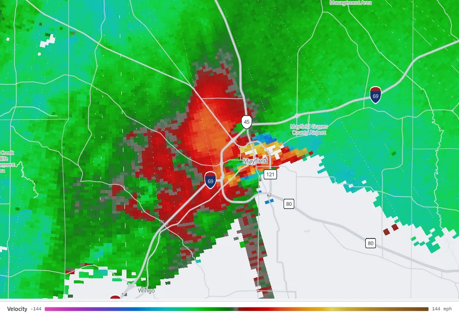
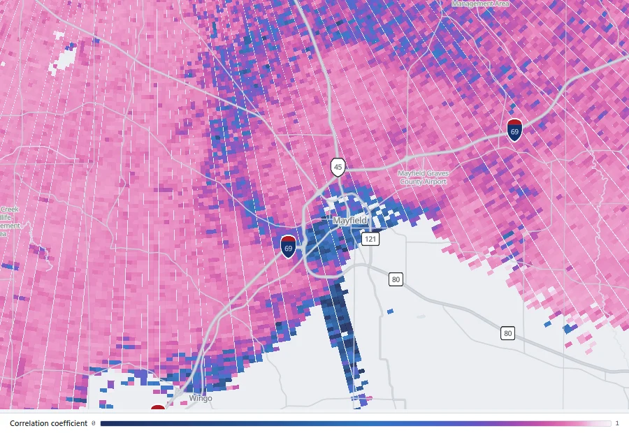
Replay the Greenfield storm on KDMX with velocity and correlation coefficient side by side, and watch the debris signature appear.
Open in the archiveIn 2024 the debris signature was visible from Des Moines about a minute after the tornado entered Greenfield. Before dual polarization, an "observed" tag depended on someone seeing the tornado, which in a rain-wrapped storm or at night was often nobody. The Joplin radar in 2011 had no dual-pol; the first statement naming a confirmed tornado came at 5:39 pm, when a hook echo and a large debris ball appeared in reflectivity, five minutes after touchdown.
The tiers above a warning
Since the impact-based warning format was adopted, a tornado warning has carried a second tag beneath the source: a damage-threat tier. There are three, and the directive defines each.[8]
| Tier | Tag line | When | What the text says |
|---|---|---|---|
| Base | none | The default. Source may be radar indicated or observed. | "Tornado" as the hazard; the standard take-cover text. |
| Considerable | TORNADO DAMAGE THREAT...CONSIDERABLE | "In situations when a tornado is occurring, whether from high confidence in evidential features in radar data and/or visual confirmation through reliable sources." | "This is a PARTICULARLY DANGEROUS SITUATION. TAKE COVER NOW!" and the hazard "Damaging tornado." |
| Catastrophic | TORNADO DAMAGE THREAT...CATASTROPHIC | "In exceedingly rare situations, when a severe threat to human life and catastrophic damage from a tornado is imminent or ongoing," with the concurrence of the shift supervisor. | The headline "TORNADO EMERGENCY FOR [locations]," the source forced to "observed," and the hazard "Deadly tornado." |
The Greenfield statement above was a considerable-tier warning. A tornado emergency is not a separate product; it is a tornado warning at the catastrophic tier, and its criteria are strict: "Use of the 'Catastrophic' damage threat categorization and thereby the 'TORNADO EMERGENCY' terminology is appropriate for the tornadic situation if all of the following criteria are met: a. Severe threat to human life is imminent or ongoing. b. Catastrophic damage is imminent or ongoing. c. Visual (1) or Radar (2): (1) Reliable sources visually confirm tornado. (2) Radar imagery (e.g., debris ball signature) strongly suggests the existence of a damaging tornado." And on who decides: "Given the gravity of the product, it should never be a single forecaster's choice, but rather a team decision with input from all relevant office staff."[8]
The phrase was invented before the rule. At 6:57 pm on May 3, 1999, NWS Norman headed a severe weather statement "TORNADO EMERGENCY IN SOUTH OKLAHOMA CITY METRO AREA" as the Bridge Creek-Moore F5 approached the city, 25 minutes before it reached Moore. Nothing in the rules of the day provided for it; the office judged that an ordinary warning would not convey what was coming.[12] The directive's requirement for supervisor concurrence exists because the words only work if they stay rare.
Severe thunderstorm warnings that mention tornadoes
A severe thunderstorm warning can carry the tag "TORNADO...POSSIBLE," to be used "only if the severe thunderstorm is suspected to have the potential to produce a tornado but forecaster confidence does not warrant a Tornado Warning at the issuance time."[8] It is the one place in the system where a tornado is mentioned without a tornado warning being issued, and it is worth taking seriously: it means the forecaster is watching that storm for rotation and may upgrade it at any minute. Severe thunderstorm warnings have their own tiers, "considerable" at 70 mph winds or golf-ball hail and "destructive" at 80 mph or baseball hail.[8]
How a warning reaches you
A watch and a warning travel by different routes, and the difference matters at 2 am.
- Wireless Emergency Alerts. Every tornado warning, at every tier, is pushed to phones inside the polygon. Severe thunderstorm warnings reach phones "only when the damage threat is destructive with winds of at least 80 mph and/or hail of 2.75 inches in diameter or greater," a change that took effect on August 2, 2021.[13] Watches are never sent by WEA. The first WEA of any kind was a flash flood warning near Santa Fe on June 28, 2012; by June 2022 the NWS had sent 60,000.[14] The alert is the reason to keep a phone charged and its emergency alerts switched on at night.
- NOAA Weather Radio and the Emergency Alert System. Both carry watches and warnings. The "BULLETIN - EAS ACTIVATION REQUESTED" line at the top of the warning above is the request to broadcasters. A weather radio with a tone alert wakes you for a warning whether or not the phone network is up.
- Sirens. Outdoor sirens are owned and sounded by cities and counties, on their own policies, and are meant to be heard outdoors. Joplin's sirens in 2011 sounded once, for three minutes, on a city policy; the federal assessment found that most residents sought a second source of confirmation before sheltering.[15] A siren is a prompt to check, not the warning itself.
- Television, apps and this site. Broadcasters relay the polygon and add what they see on radar. Apps vary in whether they alert by polygon or by county. The radar here draws current warnings on the map as context, not as an alerting service; the footer of every page says so for a reason.
How good the warnings are
The NWS measures itself against three numbers. Since October 1, 2007 the goals have been a probability of detection "greater than or equal to 72%," meaning the share of tornado track with a warning in effect, an average lead time "greater than or equal to 13 minutes," and a false alarm ratio "less than or equal to 71%," meaning the share of warnings not followed by a tornado.[16] A false alarm ratio goal of 71 percent is worth reading twice: the agency's own target accepts that most tornado warnings will not verify, because the cost of a missed tornado is measured in lives.
In July 2025 the Commerce Department's Inspector General reported on how the goals have been met: "Since FY 2011, the National Weather Service (NWS) has achieved its GPRA performance goal for false alarm ratio (FAR) in 9 out of the last 12 years. However, it has consistently fallen short of meeting performance goals for probability of detection (POD) and warning lead times during the same period." The evaluators could not determine the cause but noted that the literature "suggests the observed decline in POD and slight improvement in FAR are consistent with forecasters' actions to reduce false alarms following the tornado events occurring in spring 2011, including the Joplin, Missouri, tornado. In other words, the threshold for a forecaster to issue a tornado warning was higher after FY 2011."[16]
Table: share warned in advance, 1986 to 2016
| Year | Warned in advance |
|---|---|
| 1986 | 26.2% |
| 1987 | 20.9% |
| 1988 | 22.4% |
| 1989 | 27.1% |
| 1990 | 36.5% |
| 1991 | 33.1% |
| 1992 | 38.2% |
| 1993 | 34.6% |
| 1994 | 40.1% |
| 1995 | 53.2% |
| 1996 | 50.8% |
| 1997 | 51.2% |
| 1998 | 58.2% |
| 1999 | 63.3% |
| 2000 | 55.8% |
| 2001 | 61.5% |
| 2002 | 67.2% |
| 2003 | 71.6% |
| 2004 | 68.5% |
| 2005 | 66.6% |
| 2006 | 66.3% |
| 2007 | 68.0% |
| 2008 | 67.2% |
| 2009 | 61.4% |
| 2010 | 64.6% |
| 2011 | 70.1% |
| 2012 | 62.5% |
| 2013 | 52.8% |
| 2014 | 46.9% |
| 2015 | 52.5% |
| 2016 | 50.2% |
Brooks and Correia's 2018 study is the long view. Across 1986 to 2011 the average lead time for tornadoes that were warned in advance barely moved: "The mean over those 26 years is 18.8 min. From 2012 to 2016, it is only 15.6 min." What changed over the decades was not how early a warning came but whether one came at all: "What differs is not how long before a tornado a warning is issued, but whether a warning is issued in advance." Then, in 2012, "there was an apparent increased emphasis on reducing FAR that led to a change in the threshold for issuing warnings, such that fewer warnings were issued and lead time was reduced," alongside a shift to shorter, roughly 30-minute warnings.[17] The 2007 switch to polygons, by contrast, "shows no significant changes occurring in performance."[17]
The Doppler radars are the other half of the story. Simmons and Sutter compared about 15,000 tornadoes from 1986 to 1999 by whether each office's WSR-88D had been installed: "the percentage of tornadoes warned for increased from 35% before WSR-88D installation to 60% after installation while the mean lead time on warnings increased from 5.3 to 9.5 min and the false alarm ratio fell slightly." Expected fatalities were 45 percent lower for tornadoes after the radar arrived.[18]
The averages hide a split by strength. The Joplin service assessment cited the figures of its day: "68% of EF0-1 tornadoes receive advance warning of near 12 minutes, while 94% of EF3-5 tornadoes receive advance warning of near 18 minutes," and "Just over half (54%) of all severe weather warnings coincide with a severe weather event."[15] The tornadoes that kill are the ones most reliably warned. Where the system still fails is at the margins: brief, weak tornadoes, and the minutes between a warning and a decision.
The next step is to warn before the radar sees anything. NSSL's Warn-on-Forecast project "aims to increase lead time for tornado, severe thunderstorm, and flash flood warnings"; its page notes that "The national average for tornado warnings is currently thirteen minutes" and that "The goal is to give forecasters the ability to produce warnings that extend out to an hour."[19] On the Greenfield afternoon the experimental system flagged strong probabilities of intense low-level rotation near the town more than an hour ahead.[20]
How the system was built
For most of the first century of the Weather Bureau there were no tornado forecasts at all, by policy.

-
Sergeant John Park Finley of the Army Signal Corps "organized a team of more than 2000 'tornado reporters' east of the Rockies" and issued the first tornado alerts. They "fell out of favor" within the decade "as the Corps (and, later, the Weather Bureau) felt that mention of the word 'tornado' provoked undue fear among the public."[22][23]
-
"The ban on the word 'tornadoes' was lifted in 1938," though "very few forecasts made mention of tornadoes during the 1940s."[22]
-
Five days after a tornado destroyed 54 aircraft at Tinker Air Force Base, Fawbush and Miller told their commander the pattern had returned. That evening a second tornado struck the base "just 100 yards from the March 20 path." It was, NWS Norman writes, "the first tornado forecast ever made [that] actually verified at the same location."[21]
-
The Weather Bureau's new severe weather unit in Washington issues its first public tornado "bulletin," the ancestor of the watch. The unit became permanent on May 21, 1952, was renamed SELS in June 1953, and moved to Kansas City in 1954.[22][23]
-
SELS becomes the National Severe Storms Forecast Center. SPC's own timeline records the 1952 product as the "first watch (then called 'forecast')"; the term "watch" was in use by the NSSFC era.[22]
-
The SKYWARN spotter program is founded, to give "ground truth" for the warnings that local offices were issuing largely on reports and on WSR-57 radar.[24]
-
The WSR-88D Doppler network is installed, from Sterling, Virginia to northern Indiana, 159 radars in all.[18][25]
-
NSSFC is renamed the Storm Prediction Center and moves to Norman, Oklahoma.[23]
-
The first tornado emergency, improvised by NWS Norman for the Bridge Creek-Moore F5.[12]
-
The Enhanced Fujita scale replaces the Fujita scale; the "EF2 or greater" thresholds in the watch and outlook rules date from here.[26]
-
Storm-based warnings replace county-based warnings nationwide.[10]
-
553 tornado deaths, the most since modern records began in 1950, including 158 at Joplin. The Joplin assessment recommends "a simple, impact-based, tiered information structure that promotes warning credibility."[15][27]
-
The dual-polarization upgrade of every WSR-88D, which lets a radar see tornado debris.[25]
-
The impact-based warning demonstration begins in the Central Region; the first Wireless Emergency Alert is sent on June 28. By October 1, 2015 the demonstration covers 80 offices.[28][14]
-
Severe thunderstorm warnings gain their own tiers, and the "destructive" tier begins triggering phone alerts.[13]
-
The current edition of NWS Instruction 10-511 takes effect, with the three tornado tiers, the tornado emergency criteria and the supervisor concurrence rule as quoted above.[8]
Common misunderstandings
- "A watch means a tornado is coming." It means the ingredients are present over a region. Most watches produce no tornado near any given town; SPC's own verification goal for its strongest watches is three in four.[4]
- "No watch, so no warning is possible." A warning can be issued with no watch in effect. Brief tornadoes from storms that were not expected to organize are warned this way every year.[3]
- "My county is warned, so I am." Since 2007 the polygon is the warning. A county alert or siren may cover you when the polygon does not, and a good app will tell you which. The reverse is not true: if the polygon covers you, you are warned.[10]
- "Radar indicated means they are not sure." It means the rotation has been seen by the radar and not yet by a person or a debris signature. Most warnings for tornadoes that go on to kill start as radar-indicated warnings.
- "A tornado emergency is a different alert." It is a tornado warning at the catastrophic tier, and it arrives through the same channels. If your phone shows a tornado warning, the text will say whether it is one.[8]
- "Sirens will wake me." Sirens are for people outdoors and are sounded on local policy. For sleeping people the reliable channels are a phone with emergency alerts on and a weather radio.[15]
Video
Related
The warning chronologies of individual storms show the system at work and at its limits: Greensburg, warned 26 minutes ahead with a tornado emergency; Joplin, warned 17 minutes ahead and never given one; Plainfield, an F5 with no warning at all; and Mayfield, warned at night in December. For where these storms happen and how that has changed, see Tornado Alley: where it is and how it has moved.
All articles · Tornado profiles · How to read reflectivity, velocity and correlation coefficient
Sources
Definitions and criteria are quoted from the current NWS directives, which govern the products; where NWS public pages give rounder figures, both are shown. Product texts are as archived by the Iowa Environmental Mesonet. Times are CDT.
- National Weather Service, Understand Tornado Alerts.
- J. Graue, Normal Fire Department Uses Tacos To Educate On Weather Lingo (And Go Viral), WGLT, July 7, 2021.
- NWS Glossary: tornado watch, tornado warning, mesoscale discussion.
- Storm Prediction Center, Frequently Asked Questions (watches and PDS watches), and The Online Tornado FAQ (the four ingredients, in the answer on climate change).
- Storm Prediction Center, Probabilistic Outlook Information, and About the outlooks.
- National Weather Service Instruction 10-512, National Severe Weather Products Specification, effective April 9, 2021: sections 3.3.3 and Table 3 (outlooks), 10 (watch outline update), 12.2.2 and 12.3.3 (severe thunderstorm watches), 13.2.2 and 13.3.3 (tornado watches and PDS wording).
- Storm Prediction Center, About the SPC.
- National Weather Service Instruction 10-511, WFO Severe Weather Products Specification, effective January 26, 2023: sections 2.3.4.1 (severe thunderstorm tiers and the tornado possible tag), 3.2.4 (valid time), 3.3.4.1 (tornado tiers and tornado emergency), 3.3.5 (polygon), 5 (watch county notification).
- Storm Prediction Center, Tornado Watch 277, May 21, 2024.
- National Weather Service, Public Information Statement, Nationwide implementation of storm-based warnings beginning October 1, 2007, September 7, 2007.
- Iowa Environmental Mesonet, archived NWS Des Moines products of May 21, 2024: tornado warning, 2:55 pm, severe weather statement, 3:01 pm, and severe weather statement, 3:27 pm. The time the tornado reached Greenfield is from the Greenfield profile and its sources.
- NWS Norman, severe weather statement of 6:57 pm CDT, May 3, 1999, via the Iowa Environmental Mesonet; see the Bridge Creek-Moore profile.
- National Weather Service, Severe thunderstorm warnings with a destructive damage threat will trigger Wireless Emergency Alerts, July 22, 2021.
- National Weather Service, Wireless Emergency Alerts turn 10, June 24, 2022.
- NWS Central Region, Joplin, Missouri, Tornado, May 22, 2011: Service Assessment, July 2011; see the Joplin profile.
- U.S. Department of Commerce, Office of Inspector General, Independent Evaluation of the National Oceanic and Atmospheric Administration's National Weather Service Tornado Forecasting and Warning Services, OIG-25-026-I, July 8, 2025.
- H. E. Brooks and J. Correia, Long-Term Performance Metrics for National Weather Service Tornado Warnings, Weather and Forecasting 33(6), 2018. The chart is drawn from Table 1, column "case 1 (POD1)."
- K. M. Simmons and D. Sutter, WSR-88D Radar, Tornado Warnings, and Tornado Casualties, Weather and Forecasting 20(3), 2005.
- National Severe Storms Laboratory, Warn-on-Forecast.
- NOAA Climate.gov, Experimental Warn-on-Forecast system yields 75-minute lead time on violent tornado, 2024.
- NWS Norman, March 25, 1948: The First Tornado Forecast.
- Storm Prediction Center, SPC history: the early years and timeline.
- S. F. Corfidi, The Birth and Early Years of the Storm Prediction Center, Weather and Forecasting 14(4), 1999.
- NWS Baltimore/Washington, SKYWARN.
- NOAA NWS Heritage, Key advances in weather history: dual-pol radar.
- Storm Prediction Center, The Enhanced Fujita Scale; see the Greensburg profile for the first EF5.
- National Weather Service, 81-year list of severe weather fatalities, 2025.
- National Weather Service, Impact Based Warnings: overview and background, and Impact-Based Warnings.
- National Weather Service, Forecasts and Service, for the count of 122 Weather Forecast Offices.
Radar imagery on this page was rendered by WeatherOverTime from NOAA Level II data recorded by KDMX. The map is drawn from the coordinates in the products cited and the Census Bureau state boundaries. Corrections: contact@weatherovertime.com.