The Joplin, Missouri tornado of May 22, 2011
EF5 Jasper and Newton counties, Missouri · surveyed by NWS Springfield · the deadliest US tornado since 1947
It crossed a city of 50,000 at twenty miles an hour, three quarters of a mile wide, and killed 158 people. The warning was issued seventeen minutes before it touched down and covered the whole path. Almost nobody moved on it. Two federal investigations followed, and they disagree with each other about how strong the tornado was and about why the warning did not work.
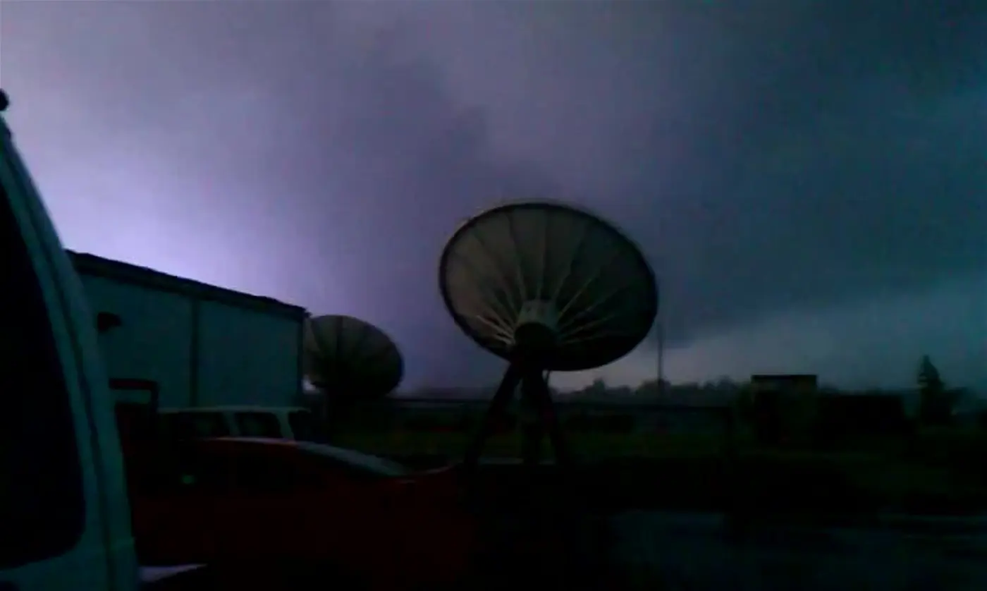
- Rating
- EF5 >200 mph estimated
- Deaths
- 158 direct
- Injuries
- 1,150+
- Path length
- 22.1 mi 6 mi through the city
- Max width
- ~1 mi
- On the ground
- 38 min 5:34–6:12 pm CDT
- Forward speed
- ~20 mph through the city
- Warning lead
- 17 min 19 min to the city
- Damage
- $2.8B 2011 USD
- Radar
- KSGF Springfield, 70 mi away
The setup
The Storm Prediction Center had a Moderate risk out for the region from the 7:55 am outlook, with Joplin inside it and inside a 10 percent probability of a significant tornado. The outlook described a corridor of surface-based CAPE up to 6,000 J/kg developing ahead of the dryline and cold front.[3] Tornado Watch 325 followed at 1:10 pm, about four hours before the tornado, with a high probability of tornadoes and a moderate probability of a significant one. It was not a particularly dangerous situation watch.[4]
Joplin sits about 70 miles west-southwest of the Springfield radar, which matters later: at that range the lowest beam samples the storm several thousand feet up, and the service assessment found the volume coverage patterns in use at both Springfield and Tulsa left velocity data obscured at the moments it was most needed.[2]
Thirty-eight minutes
The tornado touched down at 5:34 pm about half a mile southwest of the intersection of JJ Highway and Newton Road, west of the city. Storm chasers reported multiple vortices rotating around the parent circulation at the start; once it became rain-wrapped it was impossible to tell whether that continued.[1] The damage survey found a spiral ring of downed trees near South Day Road marking a brief stationary vortex, with a cell tower collapsed inside the ring.[9]
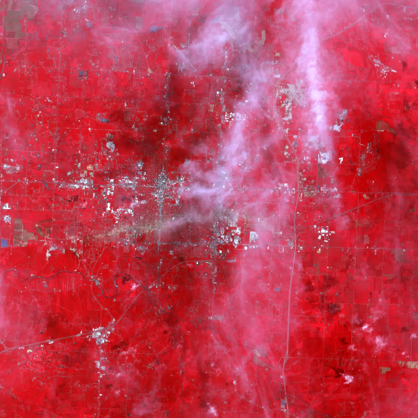
It reached EF4 intensity as it crossed Schifferdecker Avenue at about 5:38 pm and then spent roughly thirteen minutes crossing six miles of the city at about twenty miles an hour. The EF4 and EF5 damage path was about six miles long and half to three quarters of a mile wide.[2] The first EF5 damage was along South Adele Avenue: missing manhole covers, concrete parking curbs lifted out of the ground, and vehicles thrown more than a hundred metres.[9]
-
Tornado Watch 325 issued, valid to 9:00 pm.[4]
-
Tornado warning issued for western Jasper County, covering northeastern Joplin. It is for a different storm to the north.[2][5]
-
Joplin's sirens sound for three minutes, then stop. It is city policy to sound them once.[2]
-
The warning that covers Joplin is issued, on a tornado near Riverton, Kansas moving northeast at 40 mph.[5]
-
Touchdown west of the city. Seventeen minutes after the warning.[1][2]
-
Sirens sound a second time, against city policy, because reports are coming in of a tornado moving into Joplin. EF4 damage begins at Schifferdecker Avenue.[2]
-
The first statement naming a confirmed tornado: "this storm is moving into the city of Joplin." Radar shows a hook echo and a large debris ball.[2][5]
-
St John's Regional Medical Center, Greenbriar Nursing Home, the Home Depot and the Range Line Road retail corridor are struck in succession.[1][6]
-
Dissipation about five miles northeast of Granby, 22.1 miles from where it started.[1]
The radar record
KSGF carried reflectivity and velocity only. Dual-polarisation, and with it the correlation coefficient that makes lofted debris unmistakable, did not reach the network until the upgrade that ran from 2011 to 2013. Forecasters watching this tornado had the debris ball in reflectivity and nothing else.
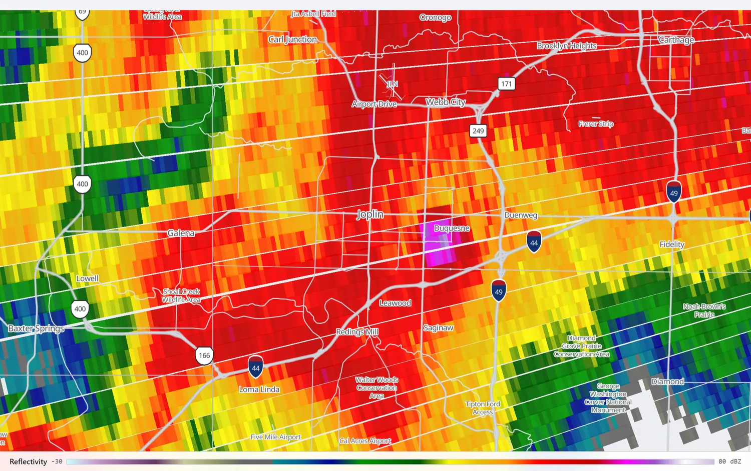
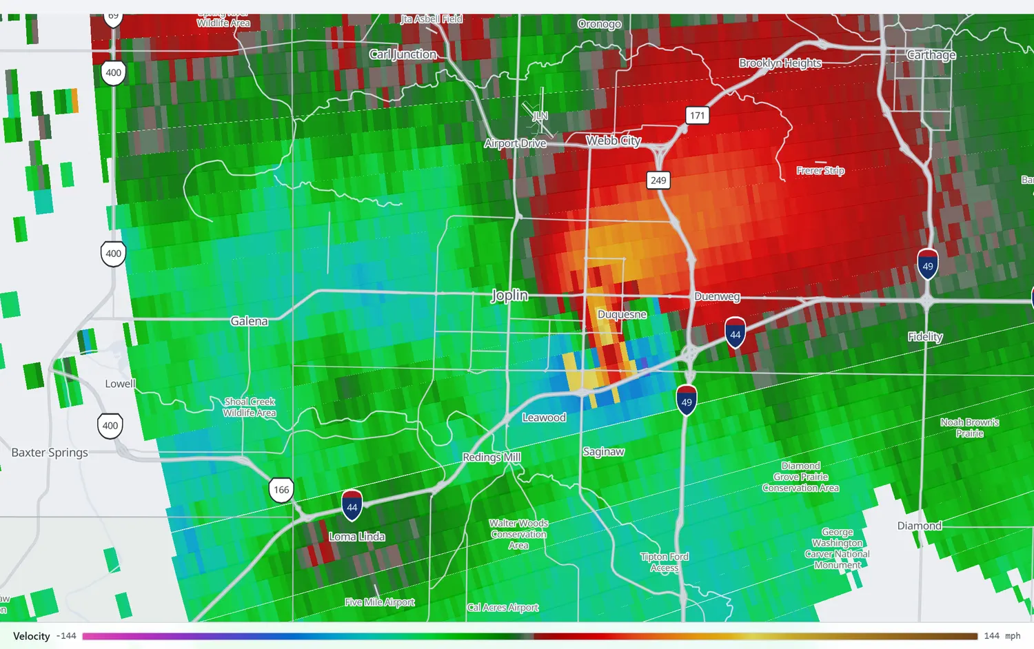
Replay the passage across the city on KSGF, reflectivity and velocity side by side, opening at 5:48 pm.
Open in the archiveThe warning nobody acted on
The National Weather Service's service assessment, published two months later, is one of the most consequential documents in the history of American warning practice, and it is largely about human behaviour rather than meteorology. Its findings are worth reading close to verbatim.
"The majority of surveyed Joplin residents did not immediately go to shelter upon hearing the initial warning, whether from local warning sirens, television, NWR, or other sources. Instead, most chose to further clarify and assess their risk by waiting for, actively seeking, and filtering additional information."
NWS Service Assessment, July 2011[2]
People took between two and nine separate risk signals before acting. The assessment reproduces one resident's nine-signal sequence in full. The thing that finally moved most of them was the second siren activation at 5:38 pm, which was not policy: Joplin sounded its sirens once, for three minutes, and several people interviewed said they had assumed the threat was over when the sound stopped.[2]
Residents told the assessment team that they "hear sirens all the time and they go off for dark clouds," that they were "bombarded with them so often that we don't pay attention," and that "all sirens mean is there is a little more water in the gutter." Others described a belief that storms always missed Joplin, a "protective bubble" around the town.[2] The assessment's central recommendation was that the Weather Service move toward an impact-based, tiered warning structure that could say when a tornado was catastrophic rather than merely present. Impact-based warnings exist today because of this document.
One detail sits awkwardly against the rest. No tornado emergency was issued for Joplin. The assessment says so plainly, notes that radar by 5:39 pm showed an unmistakable hook and debris ball, and finds that the warnings and statements "lacked enhanced wording to accurately portray that immediate action was necessary."[2]
St John's
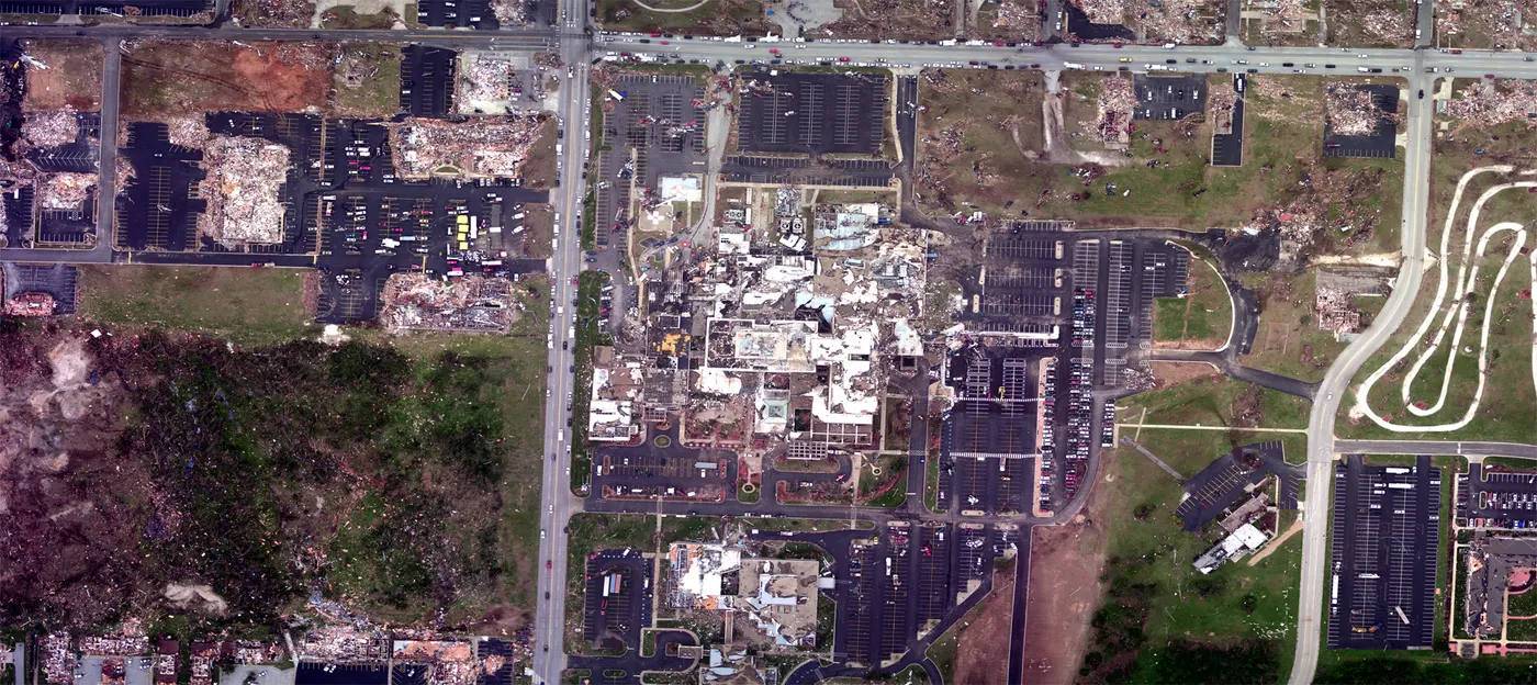
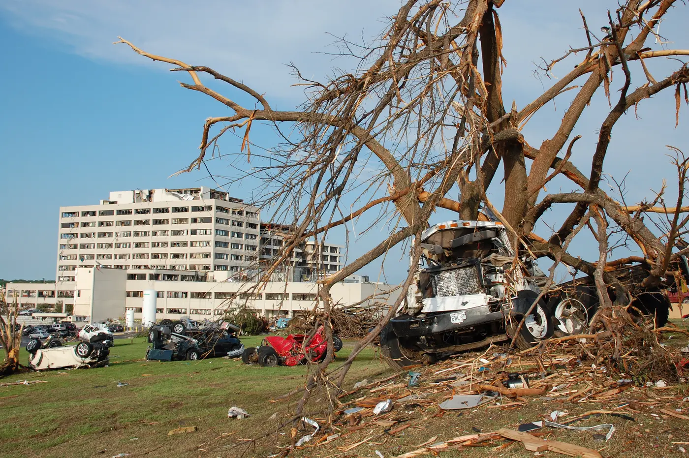
The tornado took the hospital nearly head on. Windows went on three sides, the life-flight helicopter was blown off the roof, and part of the foundation and underpinning was compromised badly enough that the building had to be demolished.[1] The structure itself did not collapse, and NIST's finding about that is the most quietly alarming sentence in either federal report: the towers "did not provide life-safety protection for all occupants, even though the towers did not collapse." Twelve impact-related deaths occurred inside, four of them patients in intensive care. What failed was the building envelope, and with it the electrical distribution, the water and gas pipes, the ductwork and the lifts.[7]
On the fifth floor of the west tower, in the behavioural health unit, most of the impact-resistant windows stayed intact while ordinary dual-pane windows elsewhere in the same building broke.[7]
"They teamed up and took every one of those patients down the stairs, and had that hospital evacuated in 90 minutes."
Drew Alexander, head of the emergency department, to KSMU[10]
What the buildings did
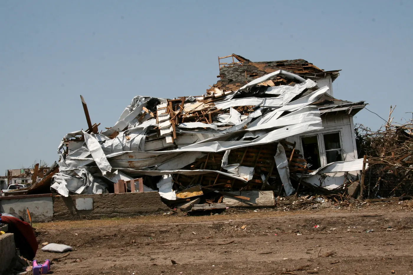
NIST's investigation is the most detailed study of building performance ever done on an American tornado, and its central finding is bleak: "regardless of construction type, neither affected residential nor non-residential buildings were able to provide life-safety protection." Of the 161 deaths it counts, 135 were related to building failure, and 74 of those were in houses.[7]
Residential failures were overwhelmingly failures of connection rather than of materials: roofs coming off walls, walls coming off foundations. The damage survey found that most Joplin homes rested on pier-and-beam foundations with the wooden sill plate sitting on the concrete and rarely attached to it.[9] There were no community shelters in Joplin or Jasper County, and 82 percent of homes had no basement.[7]
Two findings deserve to be read together. NIST found no evidence that designated refuge areas inside buildings produced better outcomes. It also found no fatalities among people who sheltered in basements of demolished detached homes, and no evidence that anyone killed was underground.[7]
How strong was it
The Weather Service rated the tornado EF5 with winds over 200 mph, arriving at that mainly through what happened to vehicles and to the ground itself: cars thrown blocks and never recovered, and 300-pound concrete parking stops, rebarred into asphalt, thrown twenty to sixty yards.[1] The rating went from a preliminary high-end EF4 on May 23 to EF5 the following day.[11]
NIST, working independently and using tree-fall analysis because no radar could see the near-surface wind at that range, put the maximum at 175 mph with up to 25 percent uncertainty, an upper bound of 210. It went further and criticised the instrument: the Enhanced Fujita scale "lacks adequate damage indicators for distinguishing among the most intense tornado events." It also found that roughly 40 percent of the deaths, and as much as 90 percent of the tornado's area, involved winds of EF3 strength or less.[7]
The two federal reports disagree about the sirens as well, and the disagreement is worth stating rather than smoothing. The service assessment's account is that Joplin residents had been desensitised by frequent siren activation. NIST checked and found the opposite as a matter of fact: since 2007 the siren system had been activated on average once a year, test soundings excluded. What NIST does confirm is that the perception existed, and that the tornado warning false-alarm rate for Joplin was 78 percent over 2005 to 2011, rising to 92 percent in the last five years of that period.[7] Both reports agree the belief drove the behaviour. They disagree about whether the belief was true.
What it changed
Impact-based warnings, which let a forecaster mark a warning as catastrophic and are now routine, came directly out of the service assessment's second recommendation.[2] NIST's sixteen recommendations went further and outward: performance-based tornado-resistant design standards, with hospitals and emergency operations centres required to remain operational; shelters in new and existing schools, multi-family housing and assembly buildings; a ban on aggregate roof surfacing in tornado-prone regions, because Joplin's roof gravel became shrapnel; and new damage indicators so the EF scale can tell the most intense tornadoes apart.[7]
One more NIST finding belongs on any page about this tornado. A disproportionate number of the dead were over 60: roughly eight deaths per thousand residents aged 60 and over, against two per thousand under 60, and that gap remains after removing every hospital and nursing home death from the count.[7]
Related
Two years later the same questions were asked about Moore, Oklahoma, where NIST's Joplin recommendations were cited directly in the reconnaissance report. For a tornado where the measurements and the damage disagreed in the other direction, see El Reno.
All tornado profiles · Search the radar archive by date and time
Sources
Times are CDT (UTC−5). Where the two federal investigations disagree, both figures are given in the text rather than reconciled.
- NWS Springfield, storm survey for the May 22, 2011 Joplin tornado. The office's original event pages are no longer live; the survey text and figures are reproduced in the service assessment below and in the NCEI record.
- NOAA/National Weather Service, Service Assessment: Joplin, Missouri, Tornado – May 22, 2011, July 2011.
- Storm Prediction Center, Day 1 Convective Outlook, 1300 UTC May 22, 2011.
- Storm Prediction Center, Tornado Watch 325, May 22, 2011.
- Iowa Environmental Mesonet, archived NWS Springfield warning products of May 22, 2011, including the 5:17 pm tornado warning and the 5:39 pm statement. These are verbatim NWS products.
- NCEI Storm Events Database, event 296617 (Jasper County, May 22, 2011), via the bulk detail files. Source of the official 158 direct and 3 indirect deaths, 1,150 injuries and $2.8 billion damage.
- Kuligowski, E. D., F. T. Lombardo, L. Phan, M. L. Levitan and D. P. Jorgensen, 2014: Final Report, NIST Technical Investigation of the May 22, 2011, Tornado in Joplin, Missouri. NIST NCSTAR 3. doi:10.6028/NIST.NCSTAR.3
- Karstens, C. D., W. A. Gallus, B. D. Lee and C. A. Finley, 2013: Analysis of Tornado-Induced Tree Fall Using Aerial Photography from the Joplin, Missouri, and Tuscaloosa–Birmingham, Alabama, Tornadoes of 2011. Journal of Applied Meteorology and Climatology, 52(5). doi:10.1175/JAMC-D-12-0206.1
- Marshall, T. P., W. Davis and S. Runnels, 2012: Damage Survey of the Joplin Tornado: 22 May 2011. 26th Conference on Severe Local Storms, American Meteorological Society, paper 6.1.
- KSMU, Scenes of heroism, lessons learned emerge from hospital ravaged by tornado, May 26, 2011.
- NWS Springfield Public Information Statements of May 23 and 24, 2011, archived by the Iowa Environmental Mesonet: the preliminary EF4 rating and the upgrade to EF5.
- NASA Earth Observatory, Tornado in Joplin, Missouri.
Radar imagery on this page was rendered by WeatherOverTime from NOAA Level II data recorded by KSGF. Corrections: contact@weatherovertime.com.