The Plainfield, Illinois tornado of August 28, 1990
F5 Kendall and Will counties, Illinois · surveyed by T. Theodore Fujita and NWS Chicago
On a 95-degree August afternoon with no tornado watch in effect, a supercell that had been throwing down hail and small tornadoes for two hours across northern Illinois turned southeast, wrapped itself in rain, and put a violent tornado through the outskirts of Chicago. It killed 29 people in half an hour, three of them at a high school the day before classes began, and nobody saw it coming: no photograph of it exists, no spotter reported it, and the tornado warning was issued after it had lifted. It is the only F5 the United States has recorded in August, and the rating rests on a cornfield.
- Rating
- F5 on corn damage; no F5 structural damage
- Path length
- 16.4 mi Oswego to Joliet
- Max width
- ~880 yd 600 yd to half a mile
- On the ground
- ~30 min 3:15–3:45 pm CDT
- Motion
- southeast 17–20 m/s, about 40 mph
- Deaths
- 29
- Injuries
- 350 "more than 300"
- Damage
- $160M 1990 USD; NCEI $250M
- Homes
- 470 destroyed, 1,000 damaged
- Radar
- WSR-74 Marseilles; reflectivity only
- Tornado warning
- 3:51 pm after the tornado
- Watch
- Severe thunderstorm 1:28 pm; no tornado watch
The setup
The morning forecast had a piece missing. Northern Illinois was under a Slight risk of severe storms, upgraded to Moderate at 9:52 am, with an upper-level trough moving through the Great Lakes and a cold front forecast to push south across the state. Temperatures reached the mid to upper 90s with dewpoints in the upper 70s, and by 3:00 pm the instability had climbed from 4,000 J/kg "to an incredible 7,000 J/kg," in NWS Chicago's retrospective. "There was one ingredient for tornadoes though that appeared to be missing: a sharp change in wind speed and direction in the lower levels." Deep-layer shear was considerable, but "without low-level shear, however, the data suggested that tornadoes may not be a prominent threat."[1] The federal survey afterwards put it the same way: the environment "did not appear supportive of supercell storms and possible tornadoes because of unfavorable wind shear in low levels" while being "characterized by extremely large convective instability."[2]
At 1:28 pm the National Severe Storms Forecast Center issued a severe thunderstorm watch for northern Illinois. No tornado watch was ever issued. Then the missing ingredient arrived: surface winds that had been northwesterly "quickly backed to the southwest," and against northwest flow aloft that gave "nearly 90 degrees of directional shear with height." Modern reanalysis puts the 250 mb winds at 80 to 85 knots, "right at record levels for late August over northern Illinois."[1]
The storm
The supercell formed near Rockford and produced its first brief tornadoes near Pecatonica around 1:42 pm. It moved southeast, to the right of the winds that should have steered it, and grew to more than 65,000 feet.[1] Fujita, whose aerial survey of the storm's whole track occupies the opening chapter of a 1993 monograph on tornadoes, mapped a downburst area 35 km long and up to 19 km wide upwind of the tornado track, beginning near DeKalb around 2:45 pm, and beneath the wall cloud inside it four vortex marks 1 to 7 km long that he rated F1 and F2. The hook echo, he wrote, "began forming at 1500 CDT."[5]
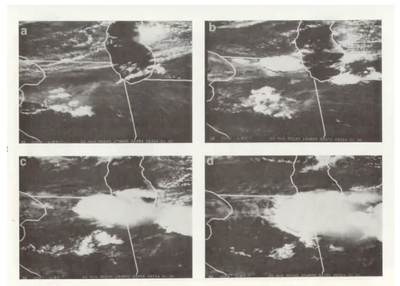
The storm's electricity was strange enough to get its own paper. Anton Seimon found that 91 percent of its cloud-to-ground lightning during development was positive, the reverse of normal; that the flash rate collapsed from 17 a minute to 3 in three minutes as the front-flank mesocyclone formed; that a 20-minute lull in lightning coincided with the tornado's formation and intensification; and that at touchdown the dominant polarity flipped from positive to negative across the whole storm, "an occurrence previously undocumented in any other tornadic thunderstorm." Later work tied the reversal to the storm's abrupt transition into a heavy-precipitation supercell, which is why nobody could see the tornado.[6]
Unwarned
The Chicago forecast office did not operate its own radar. The network radar for the area was a WSR-74 at the Weather Service Meteorological Observatory in Marseilles, fifty miles to the southwest, an office with "no official warning or forecast function." The Chicago forecasters, in NWS Chicago's own words, "could only view basic data on a TV monitor and needed to have details of what the radar operator was seeing relayed to them through radar summary products or by phone." The 1974 technology "could only tell us the intensity of precipitation."[1][11]
The federal survey, issued in May 1991, was direct about what followed. "The first two severe thunderstorm warnings issued at Chicago were for locations that remained to the north and east of the actual path of the severe weather. The large hail, damaging winds, and tornadoes in southwestern Kane, northeastern Kendall, and western Will Counties occurred, essentially, without warnings of any type in effect. The last several minutes of the major tornado were covered by a severe thunderstorm warning that included western Will County." As to why: "neither the staff at Marseilles nor Chicago recognized severe thunderstorm signatures or indicators of the storm's tornadic potential exhibited by its radar echo." And there was no ground truth to correct them. "No organized spotter networks were activated, and thus, no reports of wind damage, hail, or tornadoes were received by the Chicago NWS office until after the worst had occurred. The first report of a tornado was received as it dissipated in Joliet, after the damage had been done."[1][2]
The warnings themselves survive in the archived text. A severe thunderstorm warning for northern Kane County at 2:32 pm. Another for southern DuPage County at 3:23 pm, placing the storm near Aurora. At 3:37 pm, with the tornado already on the ground, a severe thunderstorm warning that finally included Kendall and Will counties. And at 3:51 pm the tornado warning: "At 345 PM CDT a tornado was reported at Crest Hill, a northern suburb of Joliet."[4] A 1990 New York Times report, cited widely since, said the Chicago office's Doppler add-on had been disabled by a lightning strike before the storm; the federal survey, which examined the radar operation in detail, does not mention it.[2][28]
-
Outlook upgraded to Moderate risk for northern Illinois.[1]
-
Severe thunderstorm watch. No tornado watch is issued at any point.[1]
-
First brief tornadoes near Pecatonica and Seward, west of Rockford.[1]
-
Severe thunderstorm warning, northern Kane County. The storm will pass to its south.[4]
-
Downburst winds begin near DeKalb; the hook echo forms from about 3:00.[5]
-
The hook is at its clearest on the Marseilles radar, with a weak, narrow tornado on the ground.[5]
-
The main tornado touches down on the Fox River west of Oswego, at first leaving only swirl marks in the corn.[1][5]
-
Severe thunderstorm warning, southern DuPage County.[4]
-
F3 to F5 intensity: the cornfield southeast of U.S. 30, four motorists killed on the highway, Plainfield High School, St. Mary Immaculate, Lily Cache, Interstate 55, Crystal Lawns, Crest Hill Lakes.[5]
-
Severe thunderstorm warning for Kendall, Kane, Will and DuPage counties, the first to cover the path.[4]
-
Tornado warning, west-central Will County, valid to 5:00 pm.[4]
The track
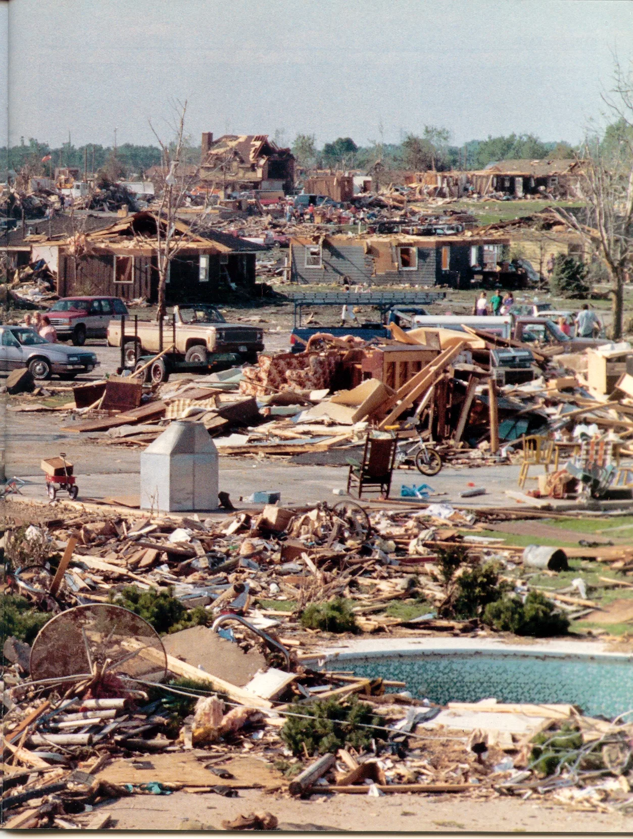
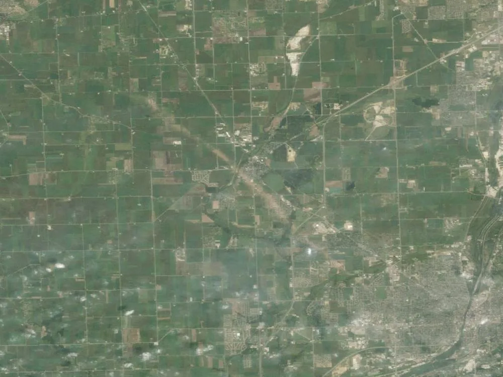
Fujita's account of the tornado is a sequence of intensities. After its touchdown near Oswego it "failed to produce continuous wind damage," leaving comma-shaped and eye-shaped marks in the fields that he judged to be suction vortices. It reached F5 in a cornfield southeast of U.S. 30, where a 20-ton trailer was blown off the highway and "bounced five times before reaching the final position 350 m (1150 ft) from the highway," and four people died in their cars. Then: "While weakening from F5 to F4, the tornado entered Plainfield, passing directly over Plainfield High School and St. Mary Immaculate School with its church. After smashing the community of Lily Cache, the tornado weakened to F2. Then it crossed Interstate 55, injuring six persons in automobiles. The tornado intensified again while passing through Crystal Lawns, where the Grand Prairie Elementary School was damaged by F3 winds. Thereafter, the core diameter shrank while weakening to F2 intensity. In Crest Hill, however, the small-core tornado intensified into F3 while passing across the Cresthill Lake apartments."[5]
Plainfield High School was in its last day before the school year. The football team was at practice; the volleyball team was in the gym. Cathy Cartright, the volleyball coach, moved her players into a hallway moments before the gymnasium's load-bearing walls came down. "It was like something was tapping me on the shoulder, telling me to get the kids out," she said twenty-five years later. Stephen Hunt, a science teacher, was killed when a semi-trailer was thrown into his classroom; two custodians also died. A football player, emerging: "We didn't know where we were. There were no trees, no houses, no landmarks."[16][18] At St. Mary Immaculate the principal, Sister Mary Keenan, the music teacher, Gloria Sanchez, and Howard Hawes Jr., the son of the parish cook, were killed.[21]
Nobody in the path saw a tornado. The cloud base was about 300 metres, the storm had wrapped its circulation in rain, and what people describe is a wall. "So we watched this big wall, big green wall," a Plainfield police commander recalled. "I'll never forget the color."[5][29] The National Weather Service's conclusion is flat: "no known photographs or videos of this tornado exist."[1]
The radar record
There is nothing here to replay. The first WSR-88D had been delivered to Oklahoma City three months before; the first field use came in November 1991, the first commissioning in February 1994, and Chicago's own radar at Romeoville around 1994, when the Marseilles observatory closed.[11][12] What the Marseilles WSR-74 recorded was reflectivity in six intensity levels, and in 2024 NWS Chicago digitised it. The three frames below are from that reconstruction.
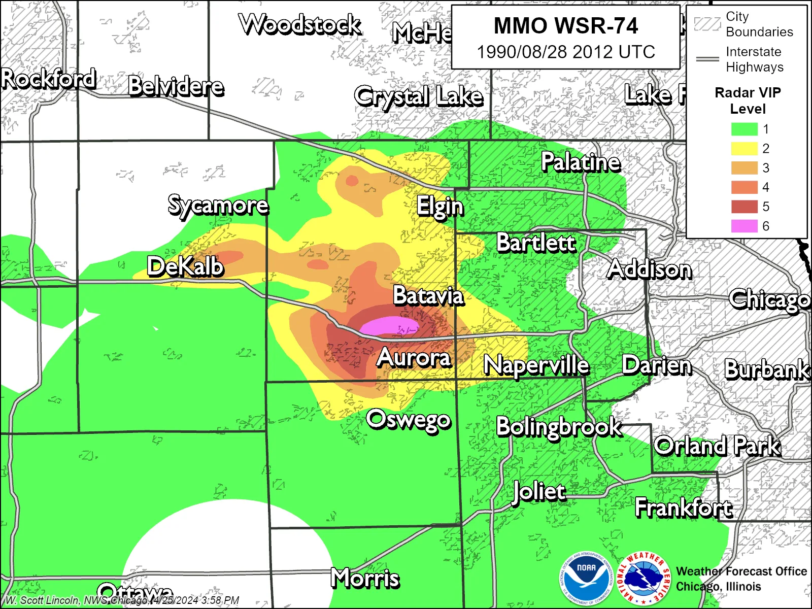
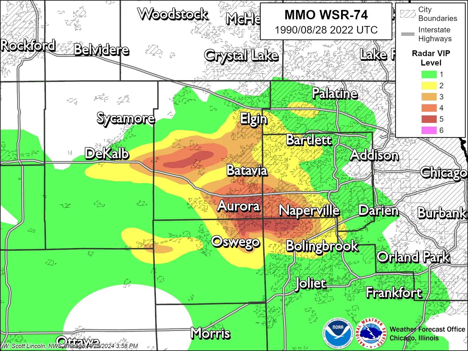
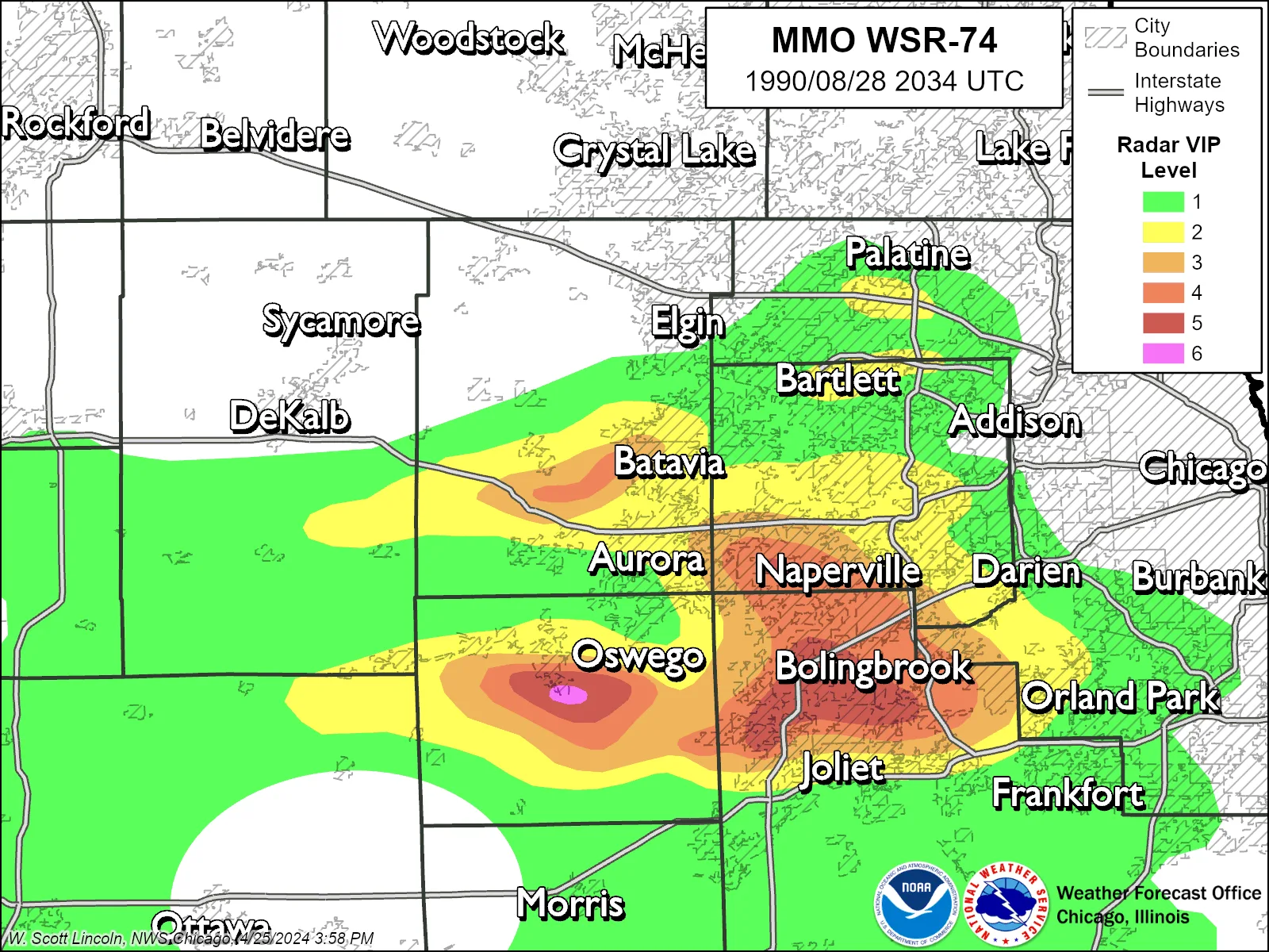
Fujita drew the lesson from the same data. "The characteristic supercell hook echo was most prominent at 3:11 p.m. CDT (2011 UT) when the weak and narrow tornado 4 was on the ground. When the Plainfield tornado at its F3-F5 intensity was on the ground from 3:25 to 3:40 p.m. CDT, however, the identity of the hook echo was not as clear, in part because of ground clutter. This evidence and judgment might have been more clear if higher-elevation scans and/or Doppler velocity fields were available for operational use."[5] The federal survey's fifth recommendation was the same in operational language: "Elevated scanning strategies should be used routinely when intense storms are located near the radar."[2]
Plainfield is often said to have accelerated the Doppler network. The documents do not support that. The survey's 21 recommendations are about training, coordination, spotters and scanning; its only mention of the WSR-88D treats the new radars as already scheduled. What the record does support is narrower and stronger: a violent tornado that the radar of 1990 could not distinguish from a hailstorm, in the words of the man who invented the scale it was rated on.[2][5]
Chicago's WSR-88D, KLOT, has recorded every storm over Plainfield since the mid-1990s. To see what the 1990 forecasters lacked, open any of them.
Search the archive by date and timeThe cornfield
Fujita's rating came from the air. Duane Stiegler flew the track from Midway the next morning, and over two days more than 600 colour photographs of 600 square kilometres were examined. "I rated the Plainfield tornado as F5," Fujita wrote, "based on the damage which was comparable to the worst I have ever seen. The damage in the cornfield southeast of U.S. 30 was entirely different from the damage adjacent to structures affected by the F3 or F4 winds. Some corn crops were stripped of leaves and ears and pushed practically down to the ground. In the worst damage area, corn crops were blown away entirely, leaving behind the remnants of small roots connected to the underground root system."[5]
The peer-reviewed literature says the same thing without softening it. A 2025 paper on the absence of EF5 ratings since 2013 notes that Plainfield "was rated F5 by Fujita (1993) based solely on damage to a corn field northwest of town," on the grounds that the corn damage was "significantly worse than corn damage found adjacent to structural damage rated F4," and states that "no F5 structural damage occurred" in the tornado.[7] In the core of that field Fujita measured the tornado's debris deposit narrowing from 70 metres to 10 before widening again. His ratings for the buildings people died in were F2 to F4: the two schools F2 to F3 by his aerial reading, Crest Hill Lakes F3. He also noted, of the houses blown off foundations in Crystal Lawns, that "most frame houses were sitting on top of poorly anchored foundations."[5]
Fujita ranks the rarity himself, and so does the database. Of the 60 tornadoes rated F5 or EF5 in the United States since 1950, this is the only one in August; twenty each fall in April and May. It is also the only F5 recorded in the Chicago area, and the last violent tornado there.[1][13]
The victims
Twenty-nine people died. The Centers for Disease Control, which counted fatal injuries including four people who died weeks later, tabulated where: "Seven persons died in one large apartment complex; eight, in vehicles; five, in schools; four, in houses; and two, outside." The dead ranged from one month to 69 years old. "Because no warning was provided," the CDC wrote, "few persons sought a tornado shelter."[8]
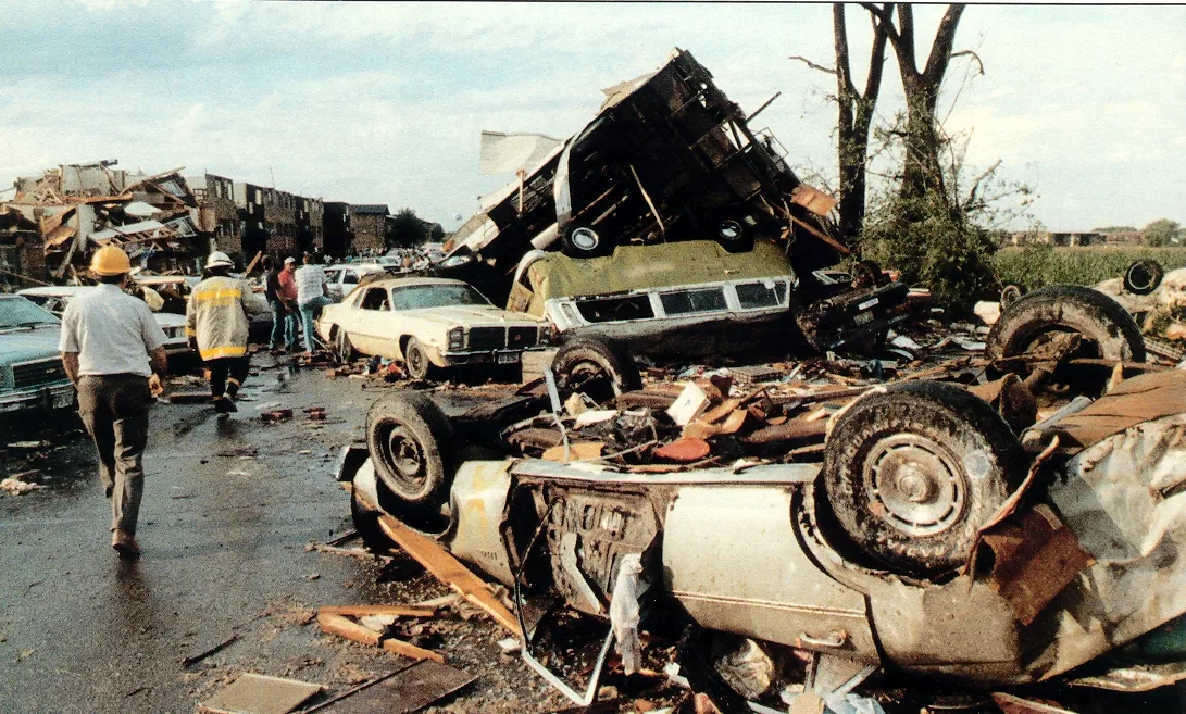
The apartment complex was Crest Hill Lakes, where the tornado, small-cored and reintensifying to F3, destroyed one building and half of another. Fujita recorded that "several persons were thrown into the cornfield to the southeast" and that by the morning of August 30 the field had yielded "seven bodies, including a 5-week-old infant. Two persons perished in cars parked by the apartment." That is why the toll at the complex is given as seven, eight or ten depending on where the counting stops.[5][20][25] Among the seven were Vicki Egizio, 38, and her children Thomas, 14, and Leslie, 4. Her son Jim, 12, survived. The infant was the child of Leticia Herrod, 17, who also died.[18][20]
"All of a sudden I heard that train sound. And it was loud. It was like three, four seconds. It was all that destruction. In seconds your life is changed in a bad way."
Brandy Butler, 17 in 1990, to the Herald-News[24]
A case-control study of the housing found something new. Comparing the 26 people killed or hospitalised in houses with 116 who were injured less severely, using tax assessor records, Brenner and Noji found that being in a multi-storey house carried nearly four times the risk of a single-storey one; that houses built after 1972 carried nearly eight times the risk of those built before 1962; and that being in a basement cut the risk by ninety percent. "The association of risk with the construction date of the house is a new finding," they wrote.[9]
Aftermath
A federal disaster declaration for Kane, Kendall and Will counties came the next day.[14] Six lawsuits against the National Weather Service, consolidated as Bergquist v. United States, alleged the office had failed to issue timely warnings and so kept the sirens silent in Plainfield and Crest Hill. In February 1994 the district court dismissed them: forecasting and warning decisions fall under the discretionary function exception to the Federal Tort Claims Act, and no statute prescribed what the forecasters had to do.[15]
The survey's findings were harsher than any court. Its conclusion that "training and preparedness activities and severe weather program oversight had not been implemented effectively at Chicago during recent years" came with recommendations to rebuild the spotter network across the whole warning area, to fix the radar displays in both offices, and to scan higher when storms were near the radar.[2] Forecasters in the region still speak of it. "We can get warning out in seconds," an NWS meteorologist told a Plainfield audience in 2025. "Back then, it took several minutes." An NWS colleague in 2015: "The early 1990s all across the United States, the Doppler radars were fielded."[17][23]
Statistically, the event never left the record. A 2011 study of tornado deaths between 1986 and 2007 found that 83 percent of August tornado fatalities in that period were unwarned, a figure "greatly influenced by the 28 August 1990 Plainfield, Illinois, tornado that was unwarned and killed 29 people." Illinois was one of only three places in the country with more than ten unwarned deaths, each "related to one event."[10]
Plainfield had about 4,500 people in 1990. It has more than 50,000 now, and the corn the tornado stripped is subdivisions. "The tornado that struck Plainfield in 1990, if it went over that same area currently, you're looking at impacts that would be ten times greater just simply due to population growth," the tornado researcher Stephen Strader said on the twenty-fifth anniversary.[16][17] The memorial, a black granite monument listing the 29 names, stands on Fort Beggs Drive across from the rebuilt high school. Each August 28 the churches ring their bells at 3:28 pm.[27]
Videos
No footage of the tornado exists. These are the storm before it, the news after it, and the two people who studied it.
Related
For another violent tornado the radar of its day could not resolve, and a warning system that did better with less, see Xenia, 1974. The first tornado emergency, and the first tornado this site can replay, is Bridge Creek-Moore, 1999, nine years and one radar network later. The 2011 Joplin page covers the other federal investigation that rewrote how warnings are worded.
All tornado profiles · Search the radar archive by date and time
Sources
Statistics in the vitals table follow NWS Chicago and the 1991 federal survey; NCEI's figures are noted where they differ. Times are CDT (UTC−5).
- NWS Chicago, The August 28, 1990 Plainfield Tornado, including the 2024 digitised WSR-74 radar reconstruction by W. Scott Lincoln.
- NOAA National Weather Service, The Plainfield/Crest Hill Tornado, Northern Illinois, August 28, 1990: Natural Disaster Survey Report, executive summary and recommendations, May 1991 (PDF). The full report is held at the NOAA Institutional Repository as document 56595.
- NCEI Storm Events Database, 1990 bulk details file, events 10002523 (Kendall County) and 10003586 (Will County), from ncei.noaa.gov/pub/data/swdi/stormevents/csvfiles/.
- Iowa Environmental Mesonet, AFOS text archive: NWS Chicago tornado warnings (TORCHI) and severe thunderstorm warnings (SVRCHI) of August 28, 1990.
- T. T. Fujita, Plainfield tornado of August 28, 1990, in The Tornado: Its Structure, Dynamics, Prediction, and Hazards, Geophysical Monograph 79, American Geophysical Union, 1993, pp. 1–17; doi:10.1029/GM079p0001. Full text from the Texas Tech University Southwest Collection.
- A. Seimon, Anomalous Cloud-to-Ground Lightning in an F5-Tornado-Producing Supercell Thunderstorm on 28 August 1990, Bulletin of the American Meteorological Society 74(2), 1993.
- A. W. Lyza, H. E. Brooks and M. J. Krocak, Where Have the EF5s Gone? A Closer Look at the "Drought" of the Most Violent Tornadoes in the United States, Bulletin of the American Meteorological Society 106, 2025.
- Centers for Disease Control, Tornado Disaster, Illinois, 1990, Morbidity and Mortality Weekly Report, 1991.
- S. A. Brenner and E. K. Noji, Tornado injuries related to housing in the Plainfield tornado, International Journal of Epidemiology 24(1), 1995.
- A. W. Black and W. S. Ashley, The Relationship between Tornadic and Nontornadic Convective Wind Fatalities and Warnings, Weather, Climate, and Society 3(1), 2011.
- NWS Central Illinois, History of the Weather Bureau and National Weather Service in Illinois (PDF), on the Marseilles observatory, 1974–1994.
- NEXRAD Radar Operations Center, NEXRAD program history (PDF).
- Storm Prediction Center, F5 and EF5 tornadoes of the United States, 1950 to present; and the SPC tornado database.
- Federal Emergency Management Agency, disaster declaration DR-878-IL, August 29, 1990, via the FEMA OpenFEMA API.
- Bergquist v. United States National Weather Service, 849 F. Supp. 1221 (N.D. Ill. 1994), summary at vLex.
- N. Steinberg, 'Get out of here! Now!' Remembering the Plainfield tornado, Chicago Sun-Times, August 27, 2015.
- ABC7 Chicago, What if the Plainfield tornado struck today?, August 28, 2015.
- ABC7 Chicago, Plainfield marks 30th anniversary of deadly 1990 tornado, August 28, 2020; and the 35th anniversary report, August 28, 2025.
- Village of Plainfield population: 4,557 in 1990 per the U.S. Census, as compiled by World Population Review.
- V. Shanker, Crest Hill, Joliet also victims of 1990 tornado, Shaw Local, August 27, 2015.
- V. Shanker, Plainfield St. Mary Immaculate commemorates tornado anniversary with prayer, display, Shaw Local, August 23, 2015.
- Shaw Local, We remember: 29 killed in 1990 Plainfield-area tornado, August 27, 2015.
- B. Okon, Plainfield tornado still has an impact 35 years later, Shaw Local / The Herald-News, March 25, 2025.
- D. M. Baran-Unland, The 1990 Plainfield tornado left a teen riding out the storm for 32 years and 2 days, The Herald-News, September 15, 2022.
- CBS Chicago, Plainfield marks 25 years after the tornado, August 28, 2015.
- E. Wahls, Illinois' only F-5 tornado remembered 35 years after Plainfield disaster, FOX 32 Chicago, August 28, 2025.
- Patch, Plainfield to mark 25 years since tornado with ceremony, July 30, 2015; and 'We will never forget': SMI hosts service for tornado victims, August 27, 2020.
- W. Robbins, Lack of Tornado Warning Prompts Assessment of Weather Service, The New York Times, August 31, 1990, as cited by Wikipedia; the article could not be retrieved for this profile.
- V. Shanker, Plainfield 1990 tornado was unique in its formation, destruction, rebuilding, Shaw Local, August 27, 2015.
The radar figures on this page are NWS Chicago's 2024 digitisation of the Marseilles WSR-74 record, not WeatherOverTime renderings; no Level II data exist for 1990. Where sources disagree on a figure, the difference is noted in the text. Corrections: contact@weatherovertime.com.