The Bridge Creek-Moore tornado of May 3, 1999
F5 Grady, McClain, Cleveland and Oklahoma counties · surveyed by NWS Norman · the fastest wind ever measured
The strongest wind ever recorded near the Earth's surface was measured inside this tornado, by a radar truck parked two kilometres away. It killed 36 people across 38 miles of Oklahoma, ending in the suburbs east of Oklahoma City. It produced the first tornado emergency the National Weather Service ever issued, a phrase invented that evening because the office could not find another way to say that this one was different. And it was the fiftieth and last tornado in the United States to be rated F5 before the scale was replaced.
- Rating
- F5 the 50th and last
- Measured wind
- ~302 mph 135 m/s at 32 m, 2007
- Path length
- 38 mi
- Max width
- 1,760 yd 1 mile
- On the ground
- 85 min 6:23–7:48 pm CDT
- Deaths
- 36 plus 5 indirect
- Injuries
- 583
- Damage
- ~$1B 1999 USD
- Warning lead
- 13–65 min by county
- Radar
- KTLX legacy, pre-super-res
Eighty-five minutes
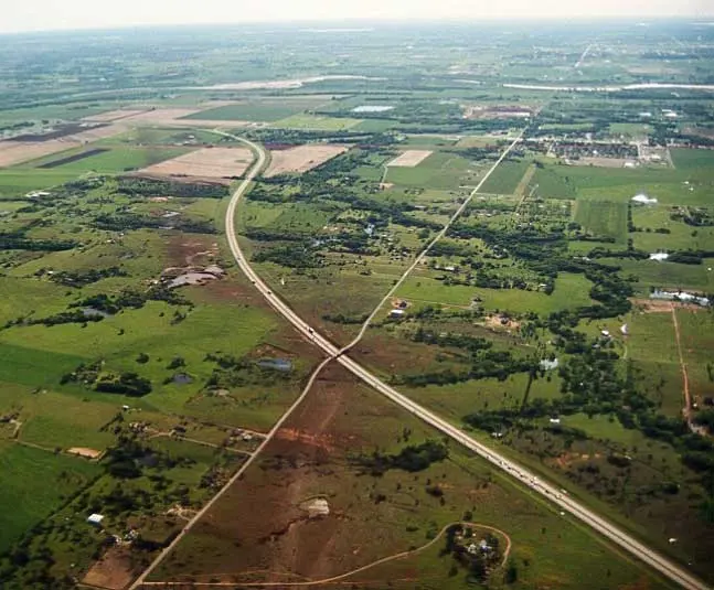
The National Weather Service calls it tornado A9: the ninth of fourteen tornadoes produced by a single supercell, "Storm A," which alone put more than seventy miles of tornado track across Oklahoma in about three and a half hours. A9 touched down about two miles south-southwest of Amber at 6:23 pm and stayed on the ground for eighty-five minutes.[1]
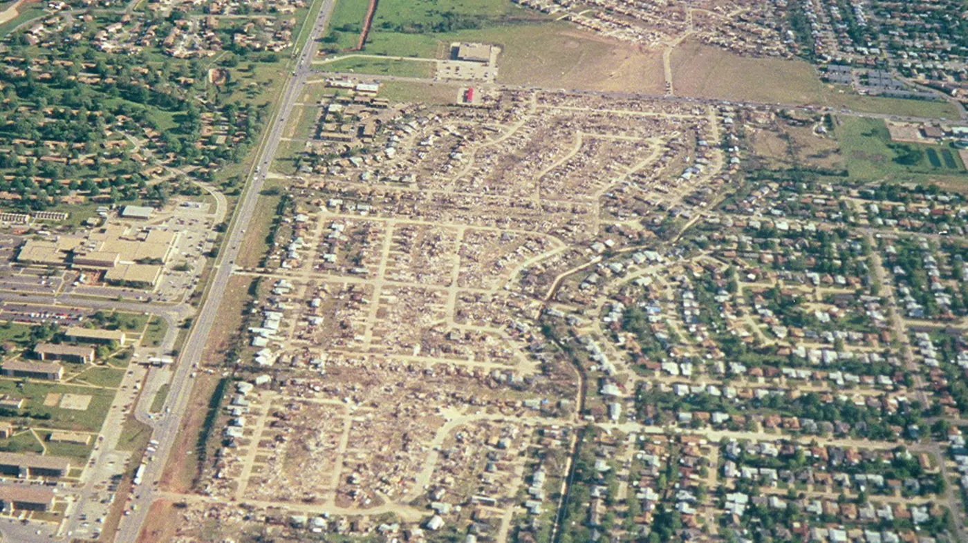
It did its worst in Bridge Creek, a rural community of scattered houses and mobile homes with no incorporated town to warn it. Twelve people died there, nine of them in mobile homes, concentrated in the Willow Lake, Southern Hills and Bridge Creek Estates additions. In Willow Lake two houses were swept from their slabs, a dozen cars were carried a quarter of a mile, and about an inch of asphalt was peeled off the road surface.[1] Roughly 200 homes and mobile homes were destroyed.
It then crossed the Canadian River, weakening briefly, and reintensified into the southern suburbs: Country Place Estates, Eastlake Estates, the Emerald Springs Apartments where a two-storey building was flattened and three people died, then Moore, then the industrial district of southeast Oklahoma City where an eighteen-ton freight car was carried three quarters of a mile, leaving gouge marks every fifty to a hundred yards. Six more died in Del City. It clipped Tinker Air Force Base, wrecked about eight hundred cars at a Midwest City dealership, and dissipated three blocks north of Reno Avenue at 7:48 pm.[1]
-
First tornado warning of the day from NWS Norman. Over the next ten hours the office issues 70 tornado warnings.[4]
-
A9 touches down two miles south-southwest of Amber, in Grady County. That county had 65 minutes of warning.[1][4]
-
Bridge Creek. Two separate areas of F5 damage; twelve deaths, nine in mobile homes.[1]
-
A Doppler on Wheels radar 1.9 km away records 135 m/s at 32 m above the ground, the fastest wind ever measured.[5]
-
NWS Norman issues the first tornado emergency, 25 minutes before the tornado reaches Moore and south Oklahoma City.[6][4]
-
Crosses northern Newcastle, passing directly over the 16th Street overpass, where a woman is blown out from underneath and killed.[1]
-
Moore. Four deaths, including a woman blown out from under the Shields Boulevard overpass on I-35.[1][7]
-
Dissipates in Midwest City, 38 miles from where it started.[1]
The radar record
This is the oldest event on this site that our archive can draw, and it looks it. In 1999 the WSR-88D network was still recording in the legacy message format: reflectivity sampled every kilometre out to 460, Doppler velocity every 250 metres out to 230, and no dual-polarisation for another twelve years. Super-resolution, which quadrupled the sampling, did not arrive until 2008. The blocky gates below are not a rendering artefact. That is the resolution forecasters actually had.
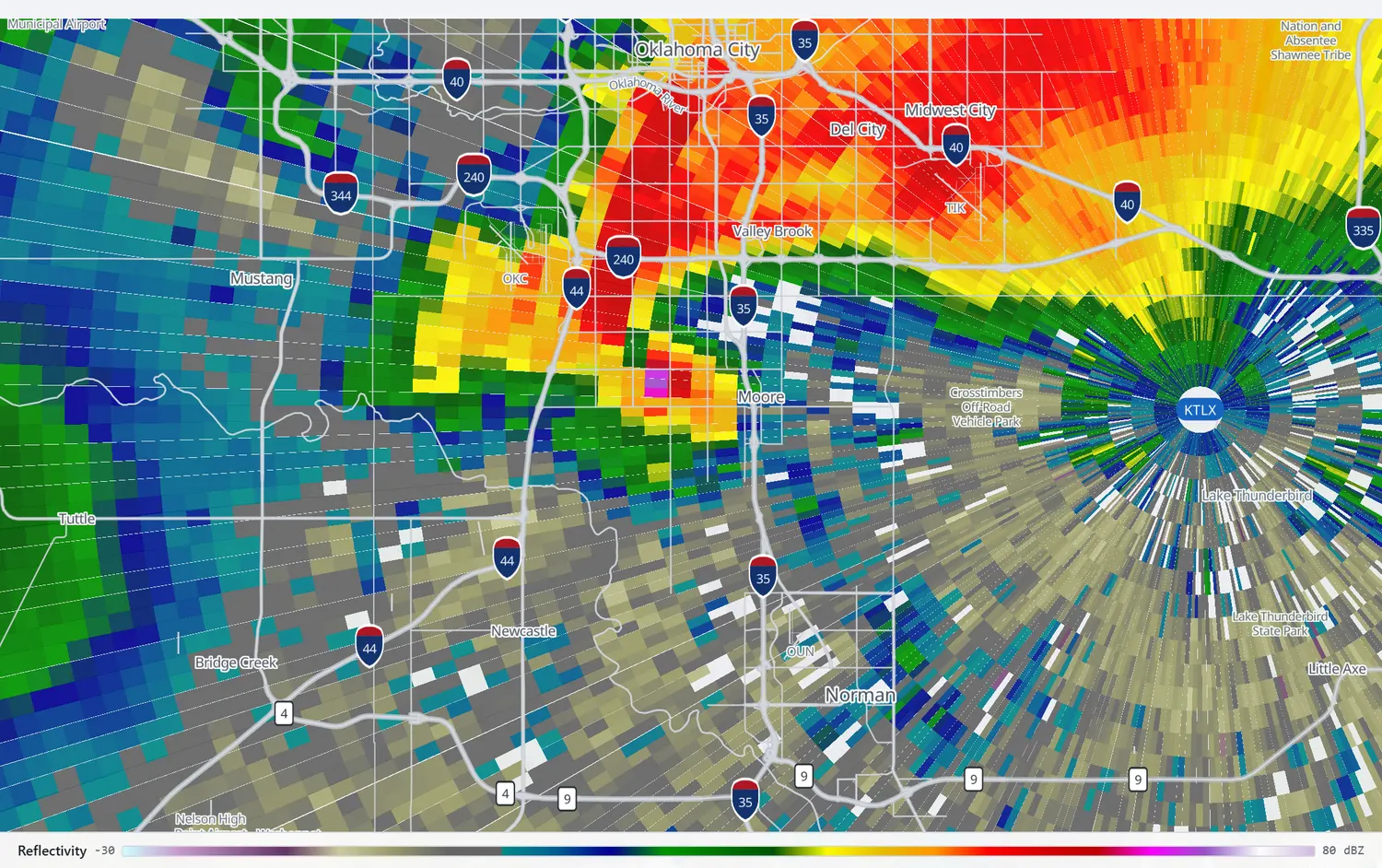
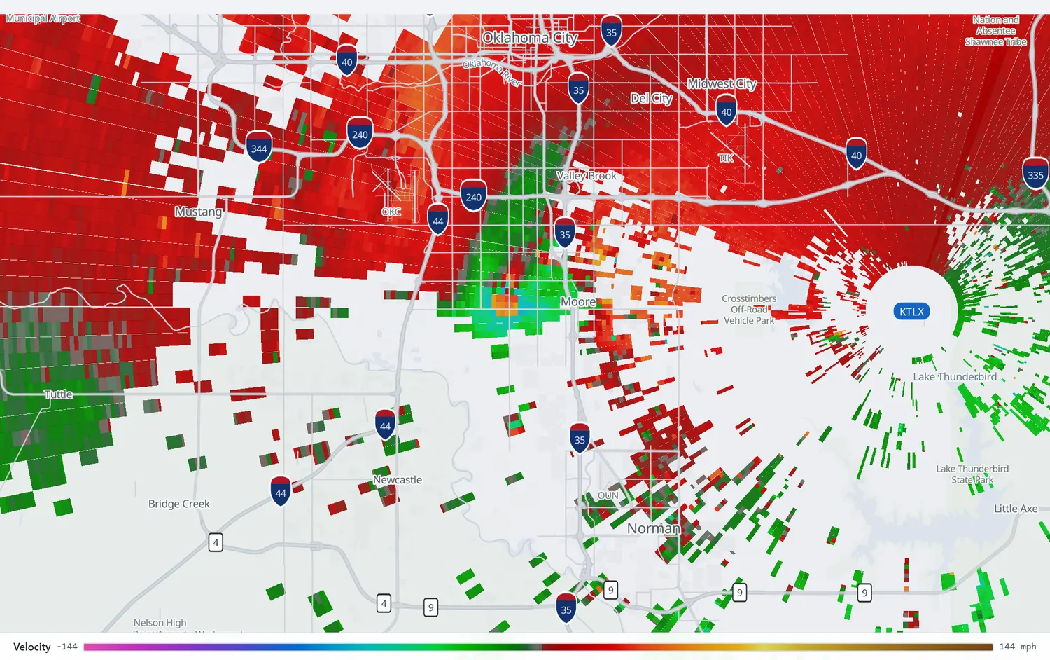
Step through the whole track on KTLX, from Bridge Creek to Midwest City, at the resolution 1999 recorded it.
Open in the archiveThe fastest wind ever measured
At 6:54 pm, as the tornado crossed Bridge Creek, a Doppler on Wheels radar was parked 1.9 km away. What it recorded is still, more than a quarter of a century later, the highest wind speed ever measured near the surface of the Earth. It is also quoted three different ways, and the differences are not rounding.
| Figure | What it is | Height | Source |
|---|---|---|---|
| 318 mph | The announcement made in 1999, before quality control. NWS Norman said at the time that review suggested the true figure was lower, though likely still above 300 | not stated | NWS Norman, 1999[1] |
| 302 mph | 135 ± 5 m/s ground-relative, the peer-reviewed value, in a circulation about 350 m across and over a region roughly 100 m wide | 32 m AGL | Wurman et al. 2007[5] |
| 322 mph | 144 m/s, the maximum in a 2021 reanalysis of 120 tornadoes that corrected for radar resolution and for the wind component the beam cannot see | 37 m ARL | Wurman et al. 2021[8] |
Two cautions belong with those numbers. The heights are measured from different datums: 32 metres above ground in the 2007 paper, 37 metres above radar level in the 2021 one, so they are not directly comparable. And the 2021 paper does not name this tornado as its 144 m/s case; the attribution is a strong inference from the same authors' earlier work rather than a statement in the text.[8]
The 2007 paper is careful about what its own measurement means, and the caution generalises to every radar wind figure quoted anywhere. Doppler velocities are means across a radar resolution volume, so brief gusts inside it were certainly higher; a three-second average would be several metres per second lower. And 32 metres is not where people are. The same authors compared radar winds at 18 metres against instruments at 3 metres and found a ratio of 0.74 to 0.80, while the damage scales are anchored to a gust at 10 metres.[5]
There is a neat arithmetic footnote to the 1999 figure. The 2007 analysis describes a quality-control filter that discards outlier velocities "as high as 142 m/s". That is 318 mph. The number announced to the world in 1999 appears to be precisely what the later, filtered analysis threw away as noise.
The first tornado emergency
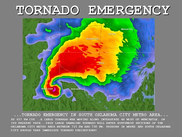
It was not a tornado warning. It was a severe weather statement updating one, and its headline was improvised. The raw transmitted text, preserved in the Iowa Environmental Mesonet's archive of National Weather Service products, reads:
"...TORNADO EMERGENCY IN SOUTH OKLAHOMA CITY METRO AREA...
AT 657 PM CDT...A LARGE TORNADO WAS MOVING ALONG INTERSTATE 44 WEST OF NEWCASTLE. ON ITS PRESENT PATH...THIS LARGE DAMAGING TORNADO WILL ENTER SOUTHWEST SECTIONS OF THE OKLAHOMA CITY METRO AREA BETWEEN 715 PM AND 730 PM. PERSONS IN MOORE AND SOUTH OKLAHOMA CITY SHOULD TAKE IMMEDIATE TORNADO PRECAUTIONS"
NWS Norman, severe weather statement, 6:57 pm CDT[6]
NWS Norman's own account of why is plain: with a violent tornado on the ground heading for the most populous place in the state, "the forecast office staff wanted to convey the message that would grab people's attention and let them know that this event was something different than normal."[1] Rick Smith, the office's warning coordination meteorologist, later described the phrase as having been "born on the fly": "We got lots of tornado warnings here. We needed a way to let them know that this was different."[9]
The service assessment credits it with working. The statement went out 25 minutes before the tornado reached Moore and south Oklahoma City, was tone-alerted on NOAA Weather Radio, "was picked up by media outlets and credited with adding the emphasis that prompted numerous residents to action."[4]
Twenty-four years later the improvisation is a written rule. NWS directive 10-511 makes "catastrophic" the highest of three damage-threat tags, adds the tornado emergency headline when it is invoked, and requires the concurrence of the on-duty shift supervisor: "Given the gravity of the product, it should never be a single forecaster's choice, but rather a team decision."[10]
The overpasses
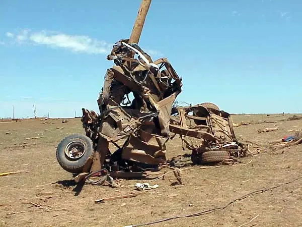
Three people were killed at or under highway overpasses during this outbreak, two of them by this tornado: one at the 16th Street overpass at Newcastle, one under the Shields Boulevard overpass on I-35 in Moore, whose body was found a week later under six to eight feet of debris.[7] About twelve people had sheltered under the Shields bridge. The survivors' injuries included compound fractures and lost fingers, ears and noses.
The Weather Service's explanation of why an overpass is worse rather than better is counter-intuitive enough to be worth stating directly. Wind speed increases with height, so climbing up under a bridge deliberately moves you into faster air. The narrow gap can accelerate the flow further. There is no shelter from debris, and "it's not the wind that causes casualties, it's what's in the wind." The wind direction can also reverse almost completely as the circulation passes, so the sheltered side becomes the exposed one.[7] Vehicles stopping under bridges also created a quarter-mile queue that blocked lanes and cut off other people's escape.
The service assessment's tenth recommendation was that national tornado safety material be updated to warn against it. The guidance every American driver now receives dates from here.[4]
Why the toll was not worse
A mile-wide F5 crossed a metropolitan area at dinner time and killed 36 people. The service assessment sets out why that number was not several times higher, and its list is unusually concrete: one very large tornado did most of the damage rather than many; warnings had long lead times; Oklahoma City television stations broadcast the tornado live, with two news helicopters flying alongside it and one station running a text box of the street names it would reach and when; and it struck in late afternoon, after schools were out and after most commuters had arrived.[4]
"Had this tornado struck during the late nighttime hours, even with the long National Weather Service tornado warning lead times, the number of casualties could have been much higher."
NWS Service Assessment, 1999[4]
The assessment also records something the Weather Service does not usually say. One television station told people to get out of the tornado's path, and many did, returning later to demolished houses. "It should be noted that fleeing a tornado is not recommended but was effective in this particular event," the assessment says, because the lead times were long enough and the tornado slow enough for it to work.[4] Fourteen years later, in the same metro, the same instinct produced the gridlock described on the El Reno page, and all eight of that tornado's victims died in cars.
Individual outcomes bear it out. In Grady County a man put 35 neighbours into his storm cellar; the F5 pulled the door open and everyone survived while their mobile homes were destroyed. At Westmoore High School an awards ceremony was in progress when the assistant principal moved everyone into interior hallways and bathrooms; the gym roof came off and nobody was hurt.[4] In Moore itself, with an estimated two thousand people in the path, five died, only three of them in well-built structures.[7]
The last F5
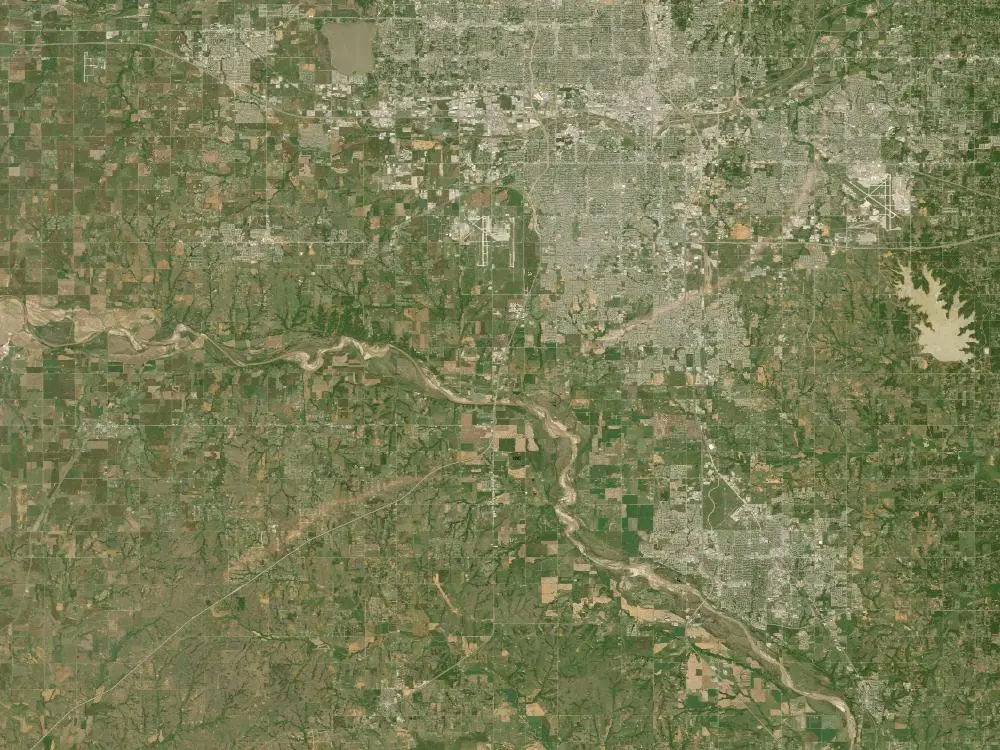
The Storm Prediction Center keeps a numbered list of every tornado the Weather Service has rated F5 or EF5 since 1950. Bridge Creek-Moore is number 50. Number 51 is Greensburg, Kansas, on May 4, 2007, the first tornado rated on the Enhanced Fujita scale that replaced Fujita's original in February that year. No tornado anywhere in the United States was rated F5 in the intervening eight years, so this is the last one there will ever be.[11]
Whether it was the strongest tornado ever is a different question, and NWS Norman answers it honestly: "Probably not, but we really have no way of knowing." Fewer than one in a thousand tornadoes has ever had its winds measured at all. Less than one percent of this tornado's roughly fifteen square miles of damage was rated F5, in small patches at Bridge Creek and in south Oklahoma City and Moore.[1]
Moore was struck again in 2003, and again in 2013, by an EF5 that crossed nearly the same ground. The damage survey of that one found that homes near Plaza Towers Elementary, built after 1999, still lacked adequate connections between their frames and their foundations.[12]
What television did
Three Oklahoma City stations carried the tornado live and continuously, with news helicopters flying alongside it and one station running a rolling list of the street names it would reach and when.[13] The most quoted moment belongs to Gary England, chief meteorologist at KWTV, who told viewers to get underground. His colleague Alex Cameron recalls the line as "If you don't get underground, you're going to die," said more than once.[14] England, who died in 2025, described the storm afterwards as "bigger, meaner, uglier, nastier than anything I had ever imagined."[15]
Whether that instruction was right has been argued about ever since, and there is real evidence on it. Hammer and Schmidlin surveyed the households in the last twenty kilometres of the path whose homes took F4 or F5 damage. Television was the warning source for 89 percent of them, far ahead of sirens at 37 percent. Forty-seven percent left their homes before the tornado arrived, and 35 percent of those who left said television had told them to get out of the path. Of the ninety people who fled, none were injured. Of the hundred who stayed, thirty percent were injured and one percent died.[16]
The authors were careful about what that does and does not license. Leaving "appears to have been a contemplated action rather than a decision induced by panic," they wrote, and the long lead times are what made it survivable.[16] Fourteen years later the same advice in the same city, with a faster tornado and less warning, produced the traffic described on the El Reno page.
Videos
Related
Moore, 2013 · El Reno, 2013, which measured winds comparable to these and was rated EF3 · All tornado profiles · Search the radar archive by date and time
Sources
Times are CDT (UTC−5). NWS Norman's own pages carry two different injury figures for this tornado, 295 and 583; the higher one is used here because the NCEI county segments sum to it.
- NWS Norman, The Great Plains Tornado Outbreak of May 3–4, 1999, including the Storm A survey, tornado data tables, FAQs and fast facts.
- NCEI Storm Events Database, events 5705284 to 5705287 (Grady, McClain, Cleveland and Oklahoma counties, May 3, 1999), via the bulk detail files. The tornado is held as four county segments summing to 37 miles, 36 deaths and 583 injuries.
- Storm Prediction Center, watches issued May 3, 1999.
- NOAA/National Weather Service, Service Assessment: Oklahoma/Southern Kansas Tornado Outbreak of May 3, 1999.
- Wurman, J., C. Alexander, P. Robinson and Y. Richardson, 2007: Low-Level Winds in Tornadoes and Potential Catastrophic Tornado Impacts in Urban Areas. Bulletin of the American Meteorological Society, 88(1), 31–46. doi:10.1175/BAMS-88-1-31
-
NWS Norman, severe weather statement of 6:57 pm CDT May 3, 1999, product
199905032357-KOUN-WWUS34-SVSOKC, in the Iowa Environmental Mesonet raw text archive. This is the transmitted product rather than a later quotation of it. - NWS Norman, Highway Overpasses as Tornado Shelters.
- Wurman, J., K. Kosiba, T. White and P. Robinson, 2021: Supercell tornadoes are much stronger and wider than damage-based ratings indicate. PNAS, 118(14), e2021535118. doi:10.1073/pnas.2021535118. See also the 2025 correction, doi:10.1073/pnas.2525962122.
- NPR, Tornado Emergency: A Rare, Dire Warning Born In Oklahoma, May 21, 2013.
- NOAA/National Weather Service, NWS Instruction 10-511, WFO Severe Weather Products Specification, January 26, 2023.
- Storm Prediction Center, F5 and EF5 tornadoes of the United States, 1950–present.
- Burgess, D., and others, 2014: 20 May 2013 Moore, Oklahoma, Tornado: Damage Survey and Analysis. Weather and Forecasting, 29, 1229–1237. doi:10.1175/WAF-D-14-00039.1
- Brooks, H. E., and C. A. Doswell III, 2002: Deaths in the 3 May 1999 Oklahoma City Tornado from a Historical Perspective. Weather and Forecasting, 17(3), 354–361. Source of the estimate that without a century of forecasting and safety change the toll would have been on the order of 500 or more.
- News 9, Alex Cameron reflects on the legacy of colleague and friend Gary England, June 11, 2025. The wording of England's on-air instruction is his colleague's recollection; no transcript of the broadcast was located.
- CBS News, A 300 mph monster.
- Hammer, B., and T. W. Schmidlin, 2002: Response to Warnings during the 3 May 1999 Oklahoma City Tornado: Reasons and Relative Injury Rates. Weather and Forecasting, 17(3), 577–581.
Radar imagery on this page was rendered by WeatherOverTime from NOAA Level II data recorded by KTLX in the legacy message format. Corrections: contact@weatherovertime.com.