M2.8 earthquake 13 km W of Stanton, Texas
A magnitude 2.8 earthquake struck 13 km W of Stanton, Texas on Tue, Feb 10, 2026, 3:36 PM CST (21:36 UTC), 9 km (6 mi) below the surface.
A larger quake followed: M3.8 21 km N of Stanton, Texas. This one was a foreshock.
Map
Where this earthquake was located, with the others nearby. Select one for its page.
The earthquake
- Magnitude
- 2.8 (ml), micro
- Local time
- UTC
- 2026-02-10 21:36:21 UTC
- Depth
- 9.2 km (5.7 mi), shallow
- Epicenter
- 32.107° N, 101.928° W
- Region
- Texas
- Felt reports
- 3
- Tsunami flag
- No
- Status
- Reviewed by a seismologist
Did you feel it?
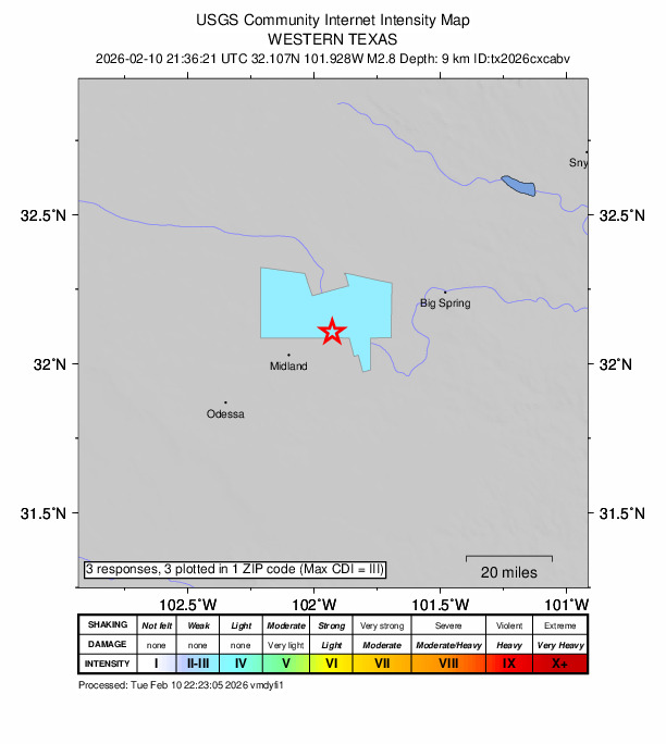
3 people reported to the USGS what they felt; the strongest reported shaking was IV, light shaking.
How well it is located
Reviewed by a seismologist.
- Location uncertainty
- About 0.2 km horizontally, 0.4 km in depth
- Magnitude uncertainty
- ±0.10
- Station coverage gap
- 35°
- Stations used
- 61
Nearest places
Distance and direction from each place to the epicenter, with its forecast.
Nearby
Within 100 km, magnitude 1.5 and up: 129 in the 60 days after this one and 84 in the 30 days before it.
After
- 2.213 km W of Stanton, Texas · 226 days ago · 9 km deep · 0 km away
- 1.613 km W of Stanton, Texas · 225 days ago · 9 km deep · 0 km away
- 1.623 km S of Westbrook, Texas · 224 days ago · 5 km deep · 82 km away
- 1.611 km W of Forsan, Texas · 224 days ago · 9 km deep · 42 km away
- 2.127 km SW of Garden City, Texas · 224 days ago · 9 km deep · 49 km away
- 2.111 km W of Forsan, Texas · 224 days ago · 8 km deep · 42 km away
- 2.411 km W of Forsan, Texas · 224 days ago · 8 km deep · 42 km away
- 1.711 km WSW of Stanton, Texas · 224 days ago · 8 km deep · 2 km away
- 1.611 km WSW of Stanton, Texas · 223 days ago · 9 km deep · 2 km away
- 2.013 km W of Stanton, Texas · 223 days ago · 9 km deep · 0 km away
- 2.623 km SW of Snyder, Texas · 222 days ago · 7 km deep · 94 km away · felt by 2
- 1.539 km WSW of Ackerly, Texas · 221 days ago · 7 km deep · 37 km away
- 1.55 km NW of Westbrook, Texas · 221 days ago · 6 km deep · 88 km away
- 1.910 km SSW of Forsan, Texas · 220 days ago · 8 km deep · 49 km away
- 1.718 km N of Stanton, Texas · 220 days ago · 6 km deep · 24 km away
- 2.55 km NW of Odessa, Texas · 219 days ago · 6 km deep · 51 km away · felt by 24
- 2.323 km SE of Coahoma, Texas · 219 days ago · 10 km deep · 76 km away
- 2.317 km ENE of Gardendale, Texas · 218 days ago · 7 km deep · 28 km away · felt by 1
- 1.78 km SE of Gardendale, Texas · 218 days ago · 8 km deep · 39 km away
- 1.624 km SSW of Westbrook, Texas · 218 days ago · 8 km deep · 81 km away
- 1.915 km E of Stanton, Texas · 217 days ago · 9 km deep · 29 km away
- 3.037 km SSW of Lamesa, Texas · 215 days ago · 8 km deep · 43 km away
- 1.540 km ENE of McKinney Acres, Texas · 215 days ago · 8 km deep · 37 km away
- 2.912 km WSW of Stanton, Texas · 215 days ago · 9 km deep · 1 km away · felt by 2
- 2.712 km WSW of Stanton, Texas · 215 days ago · 9 km deep · 1 km away · felt by 1
- 1.66 km SSW of Midland, Texas · 214 days ago · 9 km deep · 25 km away
- 1.56 km SSE of Ackerly, Texas · 213 days ago · 7 km deep · 47 km away
- 1.711 km S of Forsan, Texas · 213 days ago · 9 km deep · 55 km away
- 3.213 km N of Stanton, Texas · 213 days ago · 7 km deep · 22 km away · felt by 4
- 1.537 km ENE of McKinney Acres, Texas · 213 days ago · 9 km deep · 43 km away
- 2.318 km SE of Ackerly, Texas · 213 days ago · 8 km deep · 45 km away
- 1.530 km WSW of Ackerly, Texas · 212 days ago · 7 km deep · 35 km away
- 1.97 km NNE of Westbrook, Texas · 211 days ago · 9 km deep · 95 km away
- 2.313 km ENE of Stanton, Texas · 211 days ago · 8 km deep · 27 km away
- 2.113 km NNW of Midland, Texas · 211 days ago · 7 km deep · 20 km away · felt by 1
- 2.430 km WSW of Ackerly, Texas · 211 days ago · 7 km deep · 35 km away
- 2.813 km S of Ackerly, Texas · 210 days ago · 8 km deep · 38 km away
- 1.511 km S of Forsan, Texas · 210 days ago · 9 km deep · 55 km away
- 2.017 km NNE of Midland, Texas · 210 days ago · 9 km deep · 8 km away
- 2.412 km W of Stanton, Texas · 208 days ago · 8 km deep · 2 km away
- 2.023 km W of Garden City, Texas · 208 days ago · 9 km deep · 30 km away
- 1.522 km S of Westbrook, Texas · 207 days ago · 5 km deep · 84 km away
- 1.810 km S of Midland, Texas · 207 days ago · 9 km deep · 26 km away
- 1.913 km W of Stanton, Texas · 207 days ago · 9 km deep · 0 km away
- 2.413 km WSW of Stanton, Texas · 206 days ago · 8 km deep · 1 km away
- 2.224 km SSW of Westbrook, Texas · 205 days ago · 9 km deep · 80 km away
- 1.624 km SSW of Westbrook, Texas · 205 days ago · 9 km deep · 80 km away
- 1.618 km NW of Midland, Texas · 205 days ago · 8 km deep · 26 km away
- 2.619 km NW of Midland, Texas · 205 days ago · 6 km deep · 27 km away · felt by 1
- 2.924 km SSW of Westbrook, Texas · 205 days ago · 8 km deep · 80 km away · felt by 2
- 1.525 km SSW of Westbrook, Texas · 205 days ago · 8 km deep · 79 km away
- 2.212 km W of Stanton, Texas · 204 days ago · 9 km deep · 2 km away
- 1.510 km WSW of Stanton, Texas · 204 days ago · 8 km deep · 3 km away
- 3.821 km N of Stanton, Texas · 204 days ago · 6 km deep · 28 km away · felt by 7
- 1.924 km SSW of Westbrook, Texas · 203 days ago · 9 km deep · 79 km away
- 2.419 km NE of Gardendale, Texas · 203 days ago · 6 km deep · 27 km away
- 1.718 km NW of Midland, Texas · 203 days ago · 6 km deep · 26 km away
- 1.615 km SSE of Stanton, Texas · 203 days ago · 9 km deep · 23 km away
- 2.213 km W of Stanton, Texas · 203 days ago · 8 km deep · 0 km away
- 1.813 km W of Stanton, Texas · 203 days ago · 8 km deep · 0 km away
The first 60 of 129.
Before
- 1.913 km W of Stanton, Texas · 226 days ago · 9 km deep · 0 km away
- 2.213 km W of Stanton, Texas · 226 days ago · 8 km deep · 0 km away
- 1.518 km NE of Gardendale, Texas · 226 days ago · 6 km deep · 28 km away
- 1.615 km E of Stanton, Texas · 227 days ago · 8 km deep · 29 km away
- 1.912 km W of Stanton, Texas · 227 days ago · 9 km deep · 1 km away
- 1.511 km WSW of Stanton, Texas · 227 days ago · 9 km deep · 2 km away
- 2.812 km WSW of Stanton, Texas · 227 days ago · 7 km deep · 1 km away · felt by 3
- 1.523 km SW of Snyder, Texas · 227 days ago · 9 km deep · 94 km away
- 2.314 km E of Stanton, Texas · 228 days ago · 8 km deep · 28 km away
- 2.324 km NNW of Westbrook, Texas · 228 days ago · 7 km deep · 92 km away
- 1.824 km NNW of Westbrook, Texas · 228 days ago · 3 km deep · 92 km away
- 2.311 km W of Forsan, Texas · 228 days ago · 9 km deep · 41 km away
- 1.931 km WSW of Ackerly, Texas · 228 days ago · 8 km deep · 35 km away
- 1.711 km W of Forsan, Texas · 228 days ago · 9 km deep · 42 km away
- 2.06 km ESE of Big Spring, Texas · 229 days ago · 8 km deep · 50 km away
- 2.019 km SW of Ackerly, Texas · 229 days ago · 10 km deep · 35 km away
- 1.523 km SW of Snyder, Texas · 229 days ago · 8 km deep · 94 km away
- 2.020 km W of Garden City, Texas · 229 days ago · 6 km deep · 34 km away
- 1.65 km NW of Westbrook, Texas · 230 days ago · 7 km deep · 88 km away
- 1.64 km NW of Westbrook, Texas · 231 days ago · 6 km deep · 89 km away
Earthquakes todayTexas earthquakesLive radar here
Sources
From the USGS Earthquake Hazards Program and its partner networks, event tx2026cxcabv (also filed as us6000s7pr). Read Thu, Sep 24, 2026, 11:43 AM UTC.