M4.2 earthquake 137 km SE of Perryville, Alaska
A magnitude 4.2 earthquake struck 137 km SE of Perryville, Alaska on Sun, Oct 17, 2021, 11:27 AM AKDT (19:27 UTC), 34 km (21 mi) below the surface.
A larger quake followed: M5.6 115 km SSE of Perryville, Alaska. This one was a foreshock.
Map
Where this earthquake was located, with the others nearby. Select one for its page.
The earthquake
- Magnitude
- 4.2 (ml), light
- Local time
- UTC
- 2021-10-17 19:27:11 UTC
- Depth
- 33.9 km (21.1 mi), shallow
- Epicenter
- 55.052° N, 157.592° W
- Region
- Alaska
- Strongest shaking
- II, weak shaking
- PAGER alert
- Green
- Tsunami flag
- No
- Status
- Reviewed by a seismologist
Shaking
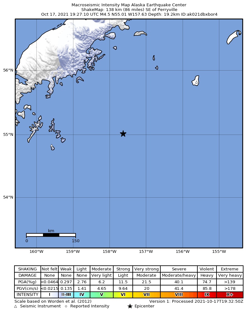
The USGS ShakeMap: shaking estimated from seismic stations and the quake’s size, on the Modified Mercalli intensity scale.
- Strongest estimated
- II, weak shaking
- Peak ground acceleration
- 0.1% of gravity
- Peak ground velocity
- -3.2 cm/s
- Map
- Automatic
Did you feel it?
No one has reported feeling this quake to the USGS.
Estimated impact
The USGS PAGER system estimates deaths and economic losses from the shaking and the population and buildings exposed to it.
- Alert level
- Green: little or no damage or loss of life expected
| Range | Chance |
|---|---|
| Under 1 | 69% |
| 1 to 10 | 29% |
| 10 to 100 | 2% |
| 100 to 1,000 | Under 1% |
| 1,000 to 10,000 | Under 1% |
| 10,000 to 100,000 | Under 1% |
| 100,000 to 10,000,000 | Under 1% |
| Range, million USD | Chance |
|---|---|
| Under 1 | 65% |
| 1 to 10 | 30% |
| 10 to 100 | 4% |
| 100 to 1,000 | Under 1% |
| 1,000 to 10,000 | Under 1% |
| 10,000 to 100,000 | Under 1% |
| 100,000 to 10,000,000 | Under 1% |
Fault motion and ground failure
How the rock slipped, from the moment tensor, and the USGS estimate of landslides and liquefaction.
- Faulting
- Strike-slip
- Moment magnitude
- 4.6 Mwr
- Nodal plane 1
- Strike 170°, dip 27°, rake 30°
- Nodal plane 2
- Strike 53°, dip 77°, rake 114°
How well it is located
Reviewed by a seismologist.
- Stations used
- 79
Nearest places
Distance and direction from each place to the epicenter, with its forecast.
Nearby
Within 100 km, magnitude 1.5 and up: 67 in the 60 days after this one and 30 in the 30 days before it.
After
- 3.0126 km SE of Perryville, Alaska · 1803 days ago · 27 km deep · 12 km away
- 2.4120 km SSE of Chignik, Alaska · 1801 days ago · 42 km deep · 35 km away
- 2.960 km SSE of Perryville, Alaska · 1800 days ago · 25 km deep · 80 km away
- 3.0122 km SE of Chignik, Alaska · 1800 days ago · 9 km deep · 76 km away
- 2.5Alaska Peninsula · 1799 days ago · 38 km deep · 52 km away
- 2.657 km SE of Perryville, Alaska · 1798 days ago · 16 km deep · 80 km away
- 2.4120 km SSE of Perryville, Alaska · 1795 days ago · 40 km deep · 48 km away
- 2.5174 km SE of Chignik, Alaska · 1795 days ago · 38 km deep · 95 km away
- 2.6131 km SSE of Chignik, Alaska · 1793 days ago · 1 km deep · 35 km away
- 3.1137 km SSE of Perryville, Alaska · 1792 days ago · 20 km deep · 56 km away
- 5.195 km SSE of Perryville, Alaska · 1792 days ago · 28 km deep · 79 km away · felt by 3
- 2.464 km SE of Perryville, Alaska · 1792 days ago · 36 km deep · 72 km away
- 3.198 km SSE of Perryville, Alaska · 1791 days ago · 23 km deep · 78 km away
- 2.873 km SSE of Chignik, Alaska · 1790 days ago · 18 km deep · 74 km away
- 5.6115 km SSE of Perryville, Alaska · 1789 days ago · 25 km deep · 73 km away · felt by 5 · tsunami flag
- 3.0130 km SSE of Perryville, Alaska · 1789 days ago · 10 km deep · 66 km away
- 3.0203 km SE of Chignik, Alaska · 1788 days ago · 9 km deep · 82 km away
- 3.8213 km SE of Perryville, Alaska · 1785 days ago · 25 km deep · 76 km away
- 3.4212 km SE of Perryville, Alaska · 1785 days ago · 5 km deep · 75 km away
- 2.6144 km SE of Perryville, Alaska · 1784 days ago · 5 km deep · 24 km away
- 2.9221 km SE of Perryville, Alaska · 1784 days ago · 10 km deep · 84 km away
- 2.4117 km SSE of Perryville, Alaska · 1783 days ago · 20 km deep · 72 km away
- 3.2150 km SSE of Perryville, Alaska · 1781 days ago · 25 km deep · 33 km away
- 1.990 km SSE of Perryville, Alaska · 1781 days ago · 4 km deep · 79 km away
- 2.3129 km SE of Perryville, Alaska · 1780 days ago · 62 km deep · 19 km away
- 2.587 km ESE of Chignik, Alaska · 1780 days ago · 3 km deep · 100 km away
- 2.394 km SSE of Perryville, Alaska · 1779 days ago · 17 km deep · 59 km away
- 2.9106 km ESE of Perryville, Alaska · 1778 days ago · 26 km deep · 41 km away
- 2.745 km SE of Perryville, Alaska · 1778 days ago · 42 km deep · 92 km away
- 2.7134 km SE of Chignik, Alaska · 1778 days ago · 33 km deep · 56 km away
- 2.247 km SSE of Perryville, Alaska · 1778 days ago · 26 km deep · 95 km away
- 3.0Alaska Peninsula · 1776 days ago · 21 km deep · 22 km away
- 3.0106 km S of Perryville, Alaska · 1776 days ago · 10 km deep · 81 km away
- 2.259 km SE of Perryville, Alaska · 1775 days ago · 14 km deep · 78 km away
- 2.5153 km SSE of Chignik, Alaska · 1774 days ago · 13 km deep · 27 km away
- 2.5156 km SE of Chignik, Alaska · 1774 days ago · 25 km deep · 51 km away
- 2.8171 km SE of Perryville, Alaska · 1771 days ago · 29 km deep · 35 km away
- 3.2204 km SE of Perryville, Alaska · 1771 days ago · 3 km deep · 67 km away
- 2.4156 km SSE of Perryville, Alaska · 1771 days ago · 4 km deep · 51 km away
- 2.663 km SE of Perryville, Alaska · 1771 days ago · 19 km deep · 73 km away
- 2.5151 km SE of Chignik, Alaska · 1768 days ago · 22 km deep · 48 km away
- 2.252 km SE of Perryville, Alaska · 1768 days ago · 20 km deep · 84 km away
- 2.7151 km SE of Perryville, Alaska · 1768 days ago · 14 km deep · 16 km away
- 2.9147 km SE of Perryville, Alaska · 1768 days ago · 16 km deep · 11 km away
- 2.461 km SE of Perryville, Alaska · 1767 days ago · 17 km deep · 75 km away
- 3.3193 km SE of Perryville, Alaska · 1766 days ago · 33 km deep · 56 km away
- 3.3197 km SE of Perryville, Alaska · 1766 days ago · 25 km deep · 60 km away
- 2.6142 km SE of Perryville, Alaska · 1764 days ago · 12 km deep · 12 km away
- 3.0195 km SE of Perryville, Alaska · 1763 days ago · 25 km deep · 58 km away
- 2.3115 km SE of Perryville, Alaska · 1763 days ago · 25 km deep · 22 km away
- 2.7218 km SE of Perryville, Alaska · 1761 days ago · 33 km deep · 82 km away
- 2.079 km S of Perryville, Alaska · 1761 days ago · 20 km deep · 93 km away
- 2.967 km SE of Perryville, Alaska · 1760 days ago · 26 km deep · 69 km away
- 2.776 km SE of Perryville, Alaska · 1758 days ago · 18 km deep · 61 km away
- 3.8141 km SE of Perryville, Alaska · 1758 days ago · 12 km deep · 5 km away
- 3.7133 km SE of Perryville, Alaska · 1753 days ago · 46 km deep · 8 km away
- 2.691 km SSE of Perryville, Alaska · 1751 days ago · 7 km deep · 76 km away
- 2.252 km SE of Perryville, Alaska · 1750 days ago · 4 km deep · 85 km away
- 4.8113 km SSE of Chignik, Alaska · 1747 days ago · 7 km deep · 41 km away · felt by 1
- 3.6160 km SE of Chignik, Alaska · 1746 days ago · 25 km deep · 57 km away
The first 60 of 67.
Before
- 2.6106 km SSE of Perryville, Alaska · 1803 days ago · 34 km deep · 68 km away
- 2.682 km SSE of Perryville, Alaska · 1804 days ago · 25 km deep · 66 km away
- 4.0140 km SSE of Chignik, Alaska · 1805 days ago · 39 km deep · 30 km away
- 3.058 km SE of Perryville, Alaska · 1807 days ago · 11 km deep · 79 km away
- 3.9201 km SE of Chignik, Alaska · 1807 days ago · 4 km deep · 89 km away · felt by 1
- 2.658 km SE of Perryville, Alaska · 1810 days ago · 11 km deep · 78 km away
- 3.3189 km SE of Perryville, Alaska · 1811 days ago · 10 km deep · 57 km away
- 2.3127 km SE of Perryville, Alaska · 1814 days ago · 0 km deep · 25 km away
- 2.5208 km SE of Perryville, Alaska · 1814 days ago · 35 km deep · 72 km away
- 2.262 km SE of Perryville, Alaska · 1815 days ago · 22 km deep · 75 km away
- 2.667 km SE of Perryville, Alaska · 1815 days ago · 20 km deep · 70 km away
- 2.155 km SE of Perryville, Alaska · 1816 days ago · 14 km deep · 82 km away
- 2.8152 km SE of Chignik, Alaska · 1816 days ago · 60 km deep · 59 km away
- 2.460 km SE of Perryville, Alaska · 1821 days ago · 10 km deep · 78 km away
- 3.1south of Alaska · 1821 days ago · 8 km deep · 98 km away
- 3.3205 km SE of Perryville, Alaska · 1821 days ago · 9 km deep · 68 km away
- 3.0204 km SE of Perryville, Alaska · 1821 days ago · 1 km deep · 67 km away
- 2.765 km SE of Perryville, Alaska · 1823 days ago · 5 km deep · 73 km away
- 3.0204 km SE of Perryville, Alaska · 1824 days ago · 27 km deep · 68 km away
- 2.890 km SE of Perryville, Alaska · 1824 days ago · 27 km deep · 48 km away
Earthquakes todayAlaska earthquakesLive radar here
Sources
From the USGS Earthquake Hazards Program and its partner networks, event ak021dbxbor4 (also filed as us6000fvha). Read Thu, Sep 24, 2026, 2:12 PM UTC.