M2.1 earthquake 14 km SW of North Pole, Alaska
A magnitude 2.1 earthquake struck 14 km SW of North Pole, Alaska on Tue, Oct 5, 2021, 2:57 PM AKDT (22:57 UTC), 12 km (8 mi) below the surface.
A larger quake followed: M4.1 31 km SW of Salcha, Alaska. This one was a foreshock.
Map
Where this earthquake was located, with the others nearby. Select one for its page.
The earthquake
- Magnitude
- 2.1 (ml), micro
- Local time
- UTC
- 2021-10-05 22:57:32 UTC
- Depth
- 12.3 km (7.6 mi), shallow
- Epicenter
- 64.658° N, 147.560° W
- Region
- Alaska
- Felt reports
- 2
- Tsunami flag
- No
- Status
- Reviewed by a seismologist
Did you feel it?
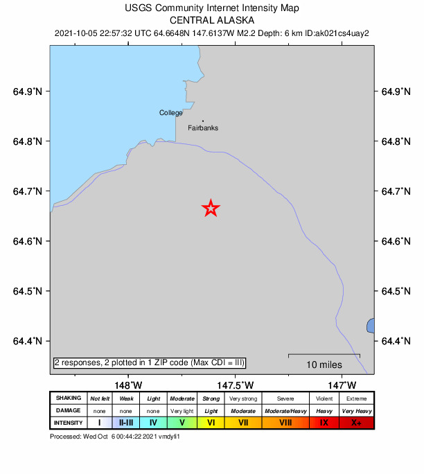
2 people reported to the USGS what they felt; the strongest reported shaking was III, weak shaking.
How well it is located
Reviewed by a seismologist.
- Stations used
- 56
Nearest places
Distance and direction from each place to the epicenter, with its forecast.
Nearby
Within 100 km, magnitude 1.5 and up: 39 in the 60 days after this one and 31 in the 30 days before it.
After
- 1.818 km NW of Four Mile Road, Alaska · 1814 days ago · 32 km deep · 87 km away
- 1.523 km WSW of Ester, Alaska · 1812 days ago · 8 km deep · 44 km away
- 2.014 km SW of North Pole, Alaska · 1812 days ago · 7 km deep · 1 km away · felt by 1
- 3.011 km NNW of Four Mile Road, Alaska · 1811 days ago · 21 km deep · 80 km away · felt by 1
- 1.515 km NW of Four Mile Road, Alaska · 1810 days ago · 19 km deep · 83 km away
- 1.513 km NNW of Four Mile Road, Alaska · 1809 days ago · 22 km deep · 81 km away
- 1.918 km NNW of Four Mile Road, Alaska · 1805 days ago · 17 km deep · 81 km away
- 2.118 km NNW of Four Mile Road, Alaska · 1805 days ago · 19 km deep · 82 km away
- 1.57 km NNW of Harding-Birch Lakes, Alaska · 1801 days ago · 4 km deep · 49 km away
- 1.610 km W of Salcha, Alaska · 1801 days ago · 0 km deep · 25 km away
- 1.631 km SE of Minto, Alaska · 1800 days ago · 17 km deep · 71 km away
- 2.6Central Alaska · 1799 days ago · 8 km deep · 47 km away
- 1.623 km N of Four Mile Road, Alaska · 1799 days ago · 19 km deep · 80 km away
- 1.543 km SW of Salcha, Alaska · 1798 days ago · 10 km deep · 50 km away
- 3.38 km NW of Harding-Birch Lakes, Alaska · 1798 days ago · 8 km deep · 48 km away · felt by 11
- 1.713 km NNW of Four Mile Road, Alaska · 1797 days ago · 22 km deep · 80 km away
- 1.814 km WSW of Salcha, Alaska · 1796 days ago · 8 km deep · 25 km away
- 1.713 km NW of Four Mile Road, Alaska · 1795 days ago · 23 km deep · 82 km away
- 1.78 km NW of Harding-Birch Lakes, Alaska · 1795 days ago · 5 km deep · 48 km away
- 1.522 km NNE of Four Mile Road, Alaska · 1791 days ago · 18 km deep · 71 km away
- 1.512 km NNW of Four Mile Road, Alaska · 1791 days ago · 21 km deep · 79 km away
- 2.210 km NW of Harding-Birch Lakes, Alaska · 1785 days ago · 11 km deep · 46 km away · felt by 1
- 3.132 km WSW of Salcha, Alaska · 1785 days ago · 8 km deep · 29 km away · felt by 46
- 4.131 km SW of Salcha, Alaska · 1785 days ago · 8 km deep · 33 km away · felt by 179
- 1.528 km WSW of Salcha, Alaska · 1785 days ago · 2 km deep · 27 km away
- 1.928 km WSW of Salcha, Alaska · 1785 days ago · 11 km deep · 27 km away
- 1.58 km NW of Harding-Birch Lakes, Alaska · 1784 days ago · 4 km deep · 48 km away
- 2.241 km SSW of South Van Horn, Alaska · 1783 days ago · 7 km deep · 32 km away
- 1.830 km WSW of Salcha, Alaska · 1782 days ago · 6 km deep · 29 km away
- 1.528 km WSW of Salcha, Alaska · 1781 days ago · 15 km deep · 25 km away
- 2.420 km N of Pleasant Valley, Alaska · 1776 days ago · 16 km deep · 57 km away
- 2.531 km SSE of Minto, Alaska · 1771 days ago · 21 km deep · 75 km away
- 1.622 km ENE of Four Mile Road, Alaska · 1768 days ago · 17 km deep · 54 km away
- 2.15 km ENE of Badger, Alaska · 1768 days ago · 17 km deep · 19 km away
- 1.534 km E of Clear, Alaska, Alaska · 1766 days ago · 4 km deep · 60 km away
- 1.714 km NW of Four Mile Road, Alaska · 1763 days ago · 23 km deep · 83 km away
- 1.78 km NW of Harding-Birch Lakes, Alaska · 1762 days ago · 5 km deep · 47 km away
- 1.54 km NNE of Fox, Alaska · 1760 days ago · 17 km deep · 38 km away
- 1.729 km WSW of Salcha, Alaska · 1756 days ago · 7 km deep · 26 km away
Before
- 1.516 km S of Minto, Alaska · 1820 days ago · 15 km deep · 91 km away
- 1.93 km SSE of Badger, Alaska · 1821 days ago · 13 km deep · 13 km away
- 1.826 km N of Four Mile Road, Alaska · 1824 days ago · 16 km deep · 72 km away
- 1.719 km N of Four Mile Road, Alaska · 1825 days ago · 22 km deep · 73 km away
- 2.08 km NW of Harding-Birch Lakes, Alaska · 1828 days ago · 10 km deep · 48 km away
- 1.815 km NNE of Healy, Alaska · 1830 days ago · 113 km deep · 97 km away
- 1.518 km NW of Four Mile Road, Alaska · 1831 days ago · 23 km deep · 86 km away
- 2.049 km ESE of Nenana, Alaska · 1833 days ago · 15 km deep · 42 km away
- 2.18 km NW of Anderson, Alaska · 1834 days ago · 3 km deep · 88 km away · felt by 2
- 3.18 km NW of Harding-Birch Lakes, Alaska · 1834 days ago · 8 km deep · 47 km away · felt by 5
- 1.910 km NNW of Harding-Birch Lakes, Alaska · 1836 days ago · 4 km deep · 47 km away
- 1.59 km NNW of Harding-Birch Lakes, Alaska · 1836 days ago · 5 km deep · 47 km away
- 1.88 km NW of Harding-Birch Lakes, Alaska · 1836 days ago · 0 km deep · 48 km away
- 1.99 km NW of Harding-Birch Lakes, Alaska · 1836 days ago · 5 km deep · 47 km away
- 2.89 km NW of Harding-Birch Lakes, Alaska · 1837 days ago · 6 km deep · 47 km away · felt by 1
- 2.08 km NNW of Harding-Birch Lakes, Alaska · 1837 days ago · 2 km deep · 48 km away · felt by 2
- 1.56 km WNW of Harding-Birch Lakes, Alaska · 1837 days ago · 4 km deep · 50 km away
- 1.77 km NNW of Harding-Birch Lakes, Alaska · 1837 days ago · 0 km deep · 49 km away · felt by 2
- 2.49 km NW of Harding-Birch Lakes, Alaska · 1837 days ago · 7 km deep · 47 km away · felt by 4
- 1.68 km NNW of Harding-Birch Lakes, Alaska · 1837 days ago · 0 km deep · 49 km away
Earthquakes todayAlaska earthquakesLive radar here
Sources
From the USGS Earthquake Hazards Program and its partner networks, event ak021cs4uay2 (also filed as us6000fs4m). Read Fri, Sep 25, 2026, 6:35 PM UTC.