M4.5 earthquake 74 km SE of Akutan, Alaska
A magnitude 4.5 earthquake struck 74 km SE of Akutan, Alaska on Sun, Dec 12, 2021, 3:41 AM AKST (12:41 UTC), 47 km (29 mi) below the surface.
A larger quake followed: M4.8 120 km ESE of Akutan, Alaska. This one was a foreshock.
Map
Where this earthquake was located, with the others nearby. Select one for its page.
The earthquake
- Magnitude
- 4.5 (mb), light
- Local time
- UTC
- 2021-12-12 12:41:08 UTC
- Depth
- 47.2 km (29.3 mi), shallow
- Epicenter
- 53.694° N, 164.912° W
- Region
- Alaska
- Strongest shaking
- II, weak shaking
- Tsunami flag
- No
- Status
- Reviewed by a seismologist
Shaking
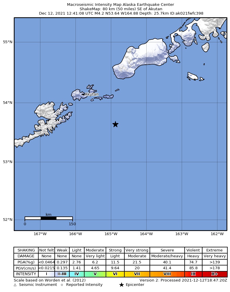
The USGS ShakeMap: shaking estimated from seismic stations and the quake’s size, on the Modified Mercalli intensity scale.
- Strongest estimated
- II, weak shaking
- Peak ground acceleration
- 0.2% of gravity
- Peak ground velocity
- -2.4 cm/s
- Map
- Automatic
Did you feel it?
No one has reported feeling this quake to the USGS.
How well it is located
Reviewed by a seismologist.
- Location uncertainty
- About 3.8 km horizontally, 6.9 km in depth
- Magnitude uncertainty
- ±0.05
- Depth from
- From location
- Station coverage gap
- 153°
- Stations used
- 160
Nearest places
Distance and direction from each place to the epicenter, with its forecast.
Nearby
Within 100 km, magnitude 1.5 and up: 105 in the 60 days after this one and 56 in the 30 days before it.
After
- 2.030 km E of Akutan, Alaska · 1747 days ago · 86 km deep · 54 km away
- 2.019 km WSW of Akutan, Alaska · 1746 days ago · 90 km deep · 83 km away
- 2.173 km SE of Unalaska, Alaska · 1746 days ago · 21 km deep · 56 km away
- 1.850 km SE of Akutan, Alaska · 1745 days ago · 56 km deep · 25 km away
- 2.7129 km SSE of Unalaska, Alaska · 1744 days ago · 10 km deep · 99 km away
- 1.973 km SE of Akutan, Alaska · 1743 days ago · 56 km deep · 17 km away
- 2.254 km ENE of Akutan, Alaska · 1743 days ago · 115 km deep · 78 km away
- 3.4Fox Islands, Aleutian Islands, Alaska · 1742 days ago · 35 km deep · 31 km away
- 2.943 km SE of Akutan, Alaska · 1741 days ago · 62 km deep · 33 km away
- 1.641 km ESE of Unalaska, Alaska · 1739 days ago · 28 km deep · 68 km away
- 1.845 km ESE of Unalaska, Alaska · 1739 days ago · 66 km deep · 65 km away
- 1.735 km E of Akutan, Alaska · 1739 days ago · 26 km deep · 56 km away
- 2.240 km SE of Unalaska, Alaska · 1739 days ago · 63 km deep · 79 km away
- 1.779 km SSE of Akutan, Alaska · 1738 days ago · 26 km deep · 36 km away
- 2.158 km SE of Unalaska, Alaska · 1738 days ago · 33 km deep · 67 km away
- 1.516 km WSW of Akutan, Alaska · 1737 days ago · 16 km deep · 86 km away
- 3.199 km SSE of Akutan, Alaska · 1737 days ago · 35 km deep · 34 km away
- 1.934 km SSE of Akutan, Alaska · 1737 days ago · 59 km deep · 49 km away
- 2.0Unimak Island region, Alaska · 1736 days ago · 39 km deep · 98 km away
- 2.1150 km SSE of Akutan, Alaska · 1736 days ago · 10 km deep · 83 km away
- 1.8108 km SE of Akutan, Alaska · 1736 days ago · 32 km deep · 34 km away
- 3.295 km SE of Akutan, Alaska · 1733 days ago · 35 km deep · 21 km away
- 2.682 km E of Akutan, Alaska · 1732 days ago · 50 km deep · 56 km away
- 1.774 km SE of Unalaska, Alaska · 1731 days ago · 13 km deep · 57 km away
- 2.897 km SE of Akutan, Alaska · 1731 days ago · 35 km deep · 23 km away
- 2.161 km SE of Akutan, Alaska · 1728 days ago · 50 km deep · 13 km away
- 2.2113 km ESE of Akutan, Alaska · 1726 days ago · 38 km deep · 50 km away
- 2.7120 km ESE of Akutan, Alaska · 1726 days ago · 35 km deep · 54 km away
- 4.261 km SE of Unalaska, Alaska · 1725 days ago · 44 km deep · 68 km away · felt by 5
- 3.729 km E of Unalaska, Alaska · 1725 days ago · 37 km deep · 80 km away
- 1.964 km S of Akutan, Alaska · 1725 days ago · 41 km deep · 49 km away
- 2.672 km SSE of Akutan, Alaska · 1723 days ago · 35 km deep · 25 km away
- 2.7123 km SE of Akutan, Alaska · 1723 days ago · 28 km deep · 50 km away
- 2.8120 km S of False Pass, Alaska · 1722 days ago · 13 km deep · 96 km away
- 3.658 km ESE of Unalaska, Alaska · 1722 days ago · 49 km deep · 59 km away
- 2.864 km SE of Akutan, Alaska · 1722 days ago · 35 km deep · 12 km away
- 1.732 km S of Akutan, Alaska · 1720 days ago · 74 km deep · 65 km away
- 2.1107 km SSW of False Pass, Alaska · 1719 days ago · 19 km deep · 73 km away
- 2.175 km E of Akutan, Alaska · 1719 days ago · 65 km deep · 65 km away
- 2.054 km E of Akutan, Alaska · 1719 days ago · 70 km deep · 51 km away
- 4.058 km SSE of Unalaska, Alaska · 1718 days ago · 43 km deep · 85 km away
- 3.1153 km SE of Akutan, Alaska · 1717 days ago · 35 km deep · 78 km away
- 2.119 km SE of Unalaska, Alaska · 1716 days ago · 77 km deep · 93 km away
- 1.837 km SE of Akutan, Alaska · 1716 days ago · 63 km deep · 37 km away
- 2.0102 km SE of Akutan, Alaska · 1716 days ago · 25 km deep · 36 km away
- 3.1119 km ESE of Akutan, Alaska · 1716 days ago · 27 km deep · 59 km away
- 2.0110 km SSW of False Pass, Alaska · 1716 days ago · 20 km deep · 70 km away
- 1.978 km ESE of Akutan, Alaska · 1715 days ago · 56 km deep · 11 km away
- 2.928 km SSE of Unalaska, Alaska · 1715 days ago · 72 km deep · 97 km away
- 2.926 km E of Unalaska, Alaska · 1714 days ago · 80 km deep · 82 km away
- 1.777 km S of Akutan, Alaska · 1713 days ago · 21 km deep · 51 km away
- 1.549 km SSE of Unalaska, Alaska · 1713 days ago · 42 km deep · 90 km away
- 2.0Fox Islands, Aleutian Islands, Alaska · 1713 days ago · 6 km deep · 83 km away
- 1.794 km S of False Pass, Alaska · 1713 days ago · 25 km deep · 96 km away
- 2.090 km E of Akutan, Alaska · 1712 days ago · 65 km deep · 46 km away
- 2.6107 km ESE of Akutan, Alaska · 1712 days ago · 35 km deep · 44 km away
- 2.0102 km ESE of Akutan, Alaska · 1712 days ago · 47 km deep · 44 km away
- 1.771 km SSE of Akutan, Alaska · 1711 days ago · 36 km deep · 46 km away
- 2.1112 km ESE of Akutan, Alaska · 1708 days ago · 58 km deep · 56 km away
- 2.0102 km ESE of Akutan, Alaska · 1708 days ago · 35 km deep · 43 km away
The first 60 of 105.
Before
- 2.268 km SE of Unalaska, Alaska · 1748 days ago · 29 km deep · 72 km away
- 3.1103 km ESE of Akutan, Alaska · 1749 days ago · 35 km deep · 36 km away
- 3.530 km E of Akutan, Alaska · 1750 days ago · 80 km deep · 52 km away
- 1.877 km SE of Unalaska, Alaska · 1750 days ago · 20 km deep · 67 km away
- 3.098 km SE of Akutan, Alaska · 1750 days ago · 24 km deep · 24 km away
- 2.8123 km ESE of Akutan, Alaska · 1753 days ago · 35 km deep · 61 km away
- 3.3122 km ESE of Akutan, Alaska · 1753 days ago · 35 km deep · 59 km away
- 2.066 km SE of Unalaska, Alaska · 1753 days ago · 39 km deep · 61 km away
- 1.832 km ESE of Akutan, Alaska · 1754 days ago · 46 km deep · 44 km away
- 1.96 km NW of Akutan, Alaska · 1754 days ago · 106 km deep · 81 km away
- 2.5133 km SE of Akutan, Alaska · 1755 days ago · 15 km deep · 62 km away
- 2.197 km S of False Pass, Alaska · 1755 days ago · 17 km deep · 97 km away
- 2.770 km SSE of Akutan, Alaska · 1755 days ago · 29 km deep · 39 km away
- 1.673 km S of Akutan, Alaska · 1757 days ago · 17 km deep · 53 km away
- 2.1107 km SSW of False Pass, Alaska · 1758 days ago · 26 km deep · 65 km away
- 1.980 km SSE of Akutan, Alaska · 1758 days ago · 26 km deep · 29 km away
- 1.958 km S of Akutan, Alaska · 1761 days ago · 55 km deep · 51 km away
- 1.780 km ESE of Akutan, Alaska · 1761 days ago · 48 km deep · 23 km away
- 1.783 km SE of Akutan, Alaska · 1761 days ago · 50 km deep · 8 km away
- 1.9139 km SE of Akutan, Alaska · 1761 days ago · 26 km deep · 68 km away
Earthquakes todayAlaska earthquakesLive radar here
Sources
From the USGS Earthquake Hazards Program and its partner networks, event us6000gbn0 (also filed as ak021fwfc398). Read Thu, Sep 24, 2026, 11:40 AM UTC.