M5.5 earthquake 185 km WSW of Adak, Alaska
A magnitude 5.5 earthquake struck 185 km WSW of Adak, Alaska on Thu, Sep 23, 2021, 10:02 PM HADT (07:02 UTC), 18 km (11 mi) below the surface.
A larger quake followed: M6.1 187 km WSW of Adak, Alaska. This one was a foreshock.
Map
Where this earthquake was located, with the others nearby. Select one for its page.
The earthquake
- Magnitude
- 5.5 (mww), moderate
- Local time
- UTC
- 2021-09-24 07:02:29 UTC
- Depth
- 18.0 km (11.2 mi), shallow
- Epicenter
- 51.134° N, 179.022° W
- Region
- Alaska
- Strongest shaking
- V, moderate shaking
- PAGER alert
- Green
- Tsunami flag
- No
- Status
- Reviewed by a seismologist
Shaking
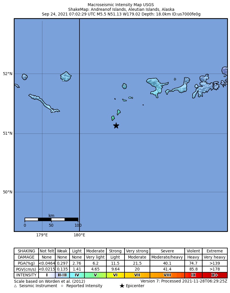
The USGS ShakeMap: shaking estimated from seismic stations and the quake’s size, on the Modified Mercalli intensity scale.
- Strongest estimated
- V, moderate shaking
- Peak ground acceleration
- 10.9% of gravity
- Peak ground velocity
- 7.8 cm/s
- Map
- Automatic
Did you feel it?
No one has reported feeling this quake to the USGS.
Estimated impact
The USGS PAGER system estimates deaths and economic losses from the shaking and the population and buildings exposed to it.
- Alert level
- Green: little or no damage or loss of life expected
| Range | Chance |
|---|---|
| Under 1 | 69% |
| 1 to 10 | 29% |
| 10 to 100 | 2% |
| 100 to 1,000 | Under 1% |
| 1,000 to 10,000 | Under 1% |
| 10,000 to 100,000 | Under 1% |
| 100,000 to 10,000,000 | Under 1% |
| Range, million USD | Chance |
|---|---|
| Under 1 | 65% |
| 1 to 10 | 30% |
| 10 to 100 | 4% |
| 100 to 1,000 | Under 1% |
| 1,000 to 10,000 | Under 1% |
| 10,000 to 100,000 | Under 1% |
| 100,000 to 10,000,000 | Under 1% |
Fault motion and ground failure
How the rock slipped, from the moment tensor, and the USGS estimate of landslides and liquefaction.
- Faulting
- Reverse (thrust)
- Moment magnitude
- 5.5 Mww
- Nodal plane 1
- Strike 267°, dip 27°, rake 112°
- Nodal plane 2
- Strike 62°, dip 65°, rake 79°
How well it is located
Reviewed by a seismologist.
- Location uncertainty
- About 3.7 km horizontally, 1.8 km in depth
- Magnitude uncertainty
- ±0.05
- Depth from
- From modeling of broad-band P waveforms
- Station coverage gap
- 56°
- Stations used
- 318
Nearby
Within 100 km, magnitude 2.5 and up: 54 in the 60 days after this one and 20 in the 30 days before it.
After
- 3.2187 km WSW of Adak, Alaska · 1828 days ago · 33 km deep · 4 km away
- 3.4184 km WSW of Adak, Alaska · 1828 days ago · 28 km deep · 1 km away
- 6.1187 km WSW of Adak, Alaska · 1827 days ago · 18 km deep · 6 km away · felt by 7 · tsunami flag
- 3.1190 km WSW of Adak, Alaska · 1825 days ago · 32 km deep · 12 km away
- 3.1179 km WSW of Adak, Alaska · 1825 days ago · 63 km deep · 31 km away
- 3.9177 km SSW of Adak, Alaska · 1824 days ago · 10 km deep · 100 km away
- 2.6247 km WSW of Adak, Alaska · 1823 days ago · 13 km deep · 63 km away
- 3.1135 km WSW of Adak, Alaska · 1823 days ago · 30 km deep · 53 km away
- 2.8209 km WSW of Adak, Alaska · 1821 days ago · 5 km deep · 26 km away
- 2.7116 km WSW of Adak, Alaska · 1819 days ago · 13 km deep · 70 km away
- 3.9116 km WSW of Adak, Alaska · 1819 days ago · 35 km deep · 70 km away
- 3.1140 km SW of Adak, Alaska · 1816 days ago · 28 km deep · 54 km away
- 2.5134 km WSW of Adak, Alaska · 1816 days ago · 21 km deep · 63 km away
- 3.9246 km WSW of Adak, Alaska · 1815 days ago · 10 km deep · 62 km away
- 2.5194 km WSW of Adak, Alaska · 1815 days ago · 18 km deep · 10 km away
- 2.5105 km WSW of Adak, Alaska · 1814 days ago · 48 km deep · 79 km away
- 2.9132 km WSW of Adak, Alaska · 1814 days ago · 10 km deep · 63 km away
- 2.6128 km WSW of Adak, Alaska · 1812 days ago · 19 km deep · 60 km away
- 2.6154 km WSW of Adak, Alaska · 1812 days ago · 21 km deep · 45 km away
- 2.5182 km WSW of Adak, Alaska · 1811 days ago · 29 km deep · 17 km away
- 3.0116 km WSW of Adak, Alaska · 1811 days ago · 34 km deep · 68 km away
- 3.1216 km W of Adak, Alaska · 1808 days ago · 110 km deep · 90 km away
- 2.7157 km WSW of Adak, Alaska · 1807 days ago · 95 km deep · 53 km away
- 3.0199 km WSW of Adak, Alaska · 1807 days ago · 10 km deep · 15 km away
- 3.2157 km SW of Adak, Alaska · 1807 days ago · 33 km deep · 76 km away
- 2.9139 km W of Adak, Alaska · 1806 days ago · 24 km deep · 87 km away
- 3.2181 km WSW of Adak, Alaska · 1805 days ago · 30 km deep · 29 km away
- 4.1194 km WSW of Adak, Alaska · 1804 days ago · 42 km deep · 10 km away
- 3.3231 km WSW of Adak, Alaska · 1802 days ago · 6 km deep · 46 km away
- 2.9245 km WSW of Adak, Alaska · 1799 days ago · 30 km deep · 64 km away
- 2.6223 km W of Adak, Alaska · 1798 days ago · 84 km deep · 83 km away
- 3.2141 km WSW of Adak, Alaska · 1794 days ago · 31 km deep · 45 km away
- 2.9236 km WSW of Adak, Alaska · 1794 days ago · 22 km deep · 52 km away
- 3.6204 km WSW of Adak, Alaska · 1794 days ago · 35 km deep · 36 km away
- 3.6Andreanof Islands, Aleutian Islands, Alaska · 1793 days ago · 82 km deep · 58 km away
- 3.1225 km WSW of Adak, Alaska · 1793 days ago · 27 km deep · 59 km away
- 3.8119 km WSW of Adak, Alaska · 1792 days ago · 88 km deep · 70 km away
- 2.9226 km W of Adak, Alaska · 1790 days ago · 102 km deep · 93 km away
- 2.9238 km WSW of Adak, Alaska · 1788 days ago · 27 km deep · 61 km away
- 2.8253 km WSW of Adak, Alaska · 1787 days ago · 70 km deep · 92 km away
- 3.6108 km WSW of Adak, Alaska · 1786 days ago · 34 km deep · 77 km away
- 2.5159 km WSW of Adak, Alaska · 1785 days ago · 72 km deep · 31 km away
- 3.1161 km WSW of Adak, Alaska · 1783 days ago · 10 km deep · 25 km away
- 2.5241 km WSW of Adak, Alaska · 1782 days ago · 33 km deep · 69 km away
- 3.1174 km WSW of Adak, Alaska · 1782 days ago · 31 km deep · 12 km away
- 2.5139 km SW of Adak, Alaska · 1779 days ago · 35 km deep · 52 km away
- 3.8Andreanof Islands, Aleutian Islands, Alaska · 1779 days ago · 21 km deep · 65 km away
- 2.7200 km W of Adak, Alaska · 1777 days ago · 89 km deep · 71 km away
- 3.3242 km WSW of Adak, Alaska · 1776 days ago · 12 km deep · 58 km away
- 3.4216 km WSW of Adak, Alaska · 1775 days ago · 33 km deep · 34 km away
- 2.6256 km WSW of Adak, Alaska · 1773 days ago · 31 km deep · 83 km away
- 5.0128 km WSW of Adak, Alaska · 1773 days ago · 48 km deep · 56 km away · felt by 1
- 2.8112 km WSW of Adak, Alaska · 1772 days ago · 22 km deep · 72 km away
- 2.6213 km WSW of Adak, Alaska · 1770 days ago · 10 km deep · 31 km away
Before
- 3.1121 km WSW of Adak, Alaska · 1828 days ago · 78 km deep · 73 km away
- 2.7221 km WSW of Adak, Alaska · 1829 days ago · 15 km deep · 38 km away
- 2.5219 km WSW of Adak, Alaska · 1829 days ago · 26 km deep · 34 km away
- 4.0257 km WSW of Adak, Alaska · 1830 days ago · 106 km deep · 96 km away
- 2.8220 km WSW of Adak, Alaska · 1831 days ago · 22 km deep · 36 km away
- 2.7201 km WSW of Adak, Alaska · 1833 days ago · 16 km deep · 17 km away
- 2.7215 km W of Adak, Alaska · 1835 days ago · 73 km deep · 69 km away
- 2.8223 km W of Adak, Alaska · 1838 days ago · 78 km deep · 74 km away
- 3.692 km SW of Adak, Alaska · 1838 days ago · 35 km deep · 97 km away
- 2.7133 km W of Adak, Alaska · 1839 days ago · 141 km deep · 93 km away
- 2.9126 km SW of Adak, Alaska · 1842 days ago · 35 km deep · 68 km away
- 2.9177 km WSW of Adak, Alaska · 1844 days ago · 30 km deep · 8 km away
- 2.8199 km WSW of Adak, Alaska · 1845 days ago · 16 km deep · 18 km away
- 3.0123 km WSW of Adak, Alaska · 1847 days ago · 33 km deep · 61 km away
- 2.6221 km WSW of Adak, Alaska · 1849 days ago · 88 km deep · 56 km away
- 2.5141 km WSW of Adak, Alaska · 1853 days ago · 30 km deep · 44 km away
- 2.687 km WSW of Adak, Alaska · 1854 days ago · 33 km deep · 98 km away
- 3.2122 km SW of Adak, Alaska · 1855 days ago · 27 km deep · 72 km away
- 3.1248 km W of Adak, Alaska · 1856 days ago · 77 km deep · 98 km away
- 3.4142 km WSW of Adak, Alaska · 1857 days ago · 17 km deep · 44 km away
Earthquakes todayAlaska earthquakesLive radar here
Sources
From the USGS Earthquake Hazards Program and its partner networks, event us7000fe0g (also filed as usauto7000fe0g, ak021c9oo6tx, iscgem621109283). Read Fri, Sep 25, 2026, 10:21 PM UTC.