M2.5 earthquake 71 km NW of Aleneva, Alaska
A magnitude 2.5 earthquake struck 71 km NW of Aleneva, Alaska on Wed, Dec 5, 2018, 5:41 AM AKST (14:41 UTC), 71 km (44 mi) below the surface.
A larger quake followed: M2.7 90 km S of Kokhanok, Alaska. This one was a foreshock.
Map
Where this earthquake was located, with the others nearby. Select one for its page.
The earthquake
- Magnitude
- 2.5 (ml), micro
- Local time
- UTC
- 2018-12-05 14:41:38 UTC
- Depth
- 70.5 km (43.8 mi), intermediate-depth
- Epicenter
- 58.533° N, 153.722° W
- Region
- Alaska
- Felt reports
- 1
- Tsunami flag
- No
- Status
- Reviewed by a seismologist
Did you feel it?
1 person reported to the USGS what they felt; the strongest reported shaking was II, weak shaking.
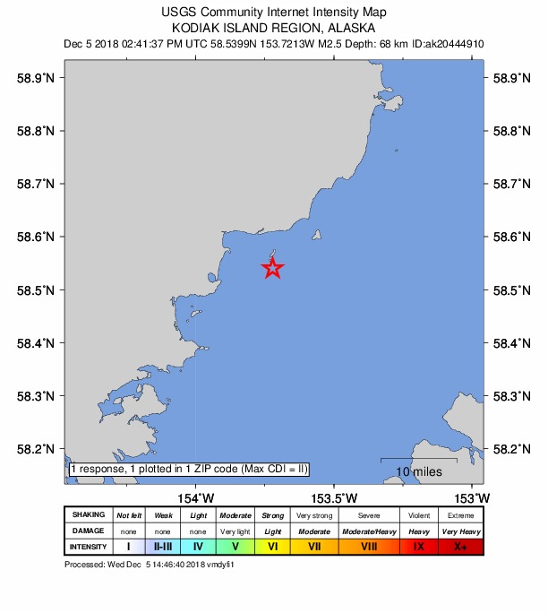
How well it is located
Reviewed by a seismologist.
- Stations used
- 62
Nearest places
Distance and direction from each place to the epicenter, with its forecast.
Nearby
Within 100 km, magnitude 1.5 and up: 136 in the 60 days after this one and 63 in the 30 days before it.
After
- 1.719 km NW of Aleneva, Alaska · 2848 days ago · 43 km deep · 52 km away
- 1.886 km S of Kokhanok, Alaska · 2848 days ago · 118 km deep · 51 km away
- 2.427 km NE of Aleneva, Alaska · 2848 days ago · 63 km deep · 70 km away
- 1.534 km NNE of Larsen Bay, Alaska · 2847 days ago · 61 km deep · 80 km away
- 2.790 km S of Kokhanok, Alaska · 2847 days ago · 97 km deep · 50 km away
- 1.868 km NW of Aleneva, Alaska · 2846 days ago · 65 km deep · 3 km away
- 1.861 km SE of Pedro Bay, Alaska · 2845 days ago · -1 km deep · 93 km away
- 1.930 km NNE of Larsen Bay, Alaska · 2843 days ago · 40 km deep · 82 km away
- 1.978 km WNW of Aleneva, Alaska · 2843 days ago · 82 km deep · 21 km away
- 1.747 km NNE of Larsen Bay, Alaska · 2843 days ago · 54 km deep · 65 km away
- 1.975 km SW of Nanwalek, Alaska · 2843 days ago · 45 km deep · 67 km away
- 2.073 km NNE of Karluk, Alaska · 2842 days ago · 72 km deep · 44 km away
- 1.884 km NW of Aleneva, Alaska · 2842 days ago · 78 km deep · 14 km away
- 2.151 km NW of Aleneva, Alaska · 2841 days ago · 64 km deep · 23 km away
- 1.778 km WSW of Nanwalek, Alaska · 2841 days ago · 66 km deep · 63 km away
- 2.839 km NNE of Ouzinkie, Alaska · 2840 days ago · 28 km deep · 90 km away
- 1.847 km WSW of Nanwalek, Alaska · 2839 days ago · 72 km deep · 97 km away
- 1.969 km W of Nanwalek, Alaska · 2838 days ago · 84 km deep · 94 km away
- 1.997 km N of Karluk, Alaska · 2837 days ago · 1 km deep · 58 km away
- 1.883 km WNW of Aleneva, Alaska · 2837 days ago · 83 km deep · 28 km away
- 1.622 km WNW of Port Lions, Alaska · 2835 days ago · 41 km deep · 74 km away
- 1.629 km N of Karluk, Alaska · 2835 days ago · 19 km deep · 90 km away
- 2.072 km SW of Nanwalek, Alaska · 2835 days ago · 61 km deep · 66 km away
- 1.698 km WNW of Aleneva, Alaska · 2835 days ago · 5 km deep · 39 km away
- 2.069 km WSW of Nanwalek, Alaska · 2834 days ago · 66 km deep · 71 km away
- 2.034 km NNE of Karluk, Alaska · 2834 days ago · 52 km deep · 82 km away
- 1.548 km N of Karluk, Alaska · 2833 days ago · 15 km deep · 69 km away
- 1.662 km SW of Nanwalek, Alaska · 2833 days ago · 61 km deep · 76 km away
- 1.755 km N of Karluk, Alaska · 2832 days ago · 75 km deep · 67 km away
- 1.880 km WSW of Nanwalek, Alaska · 2832 days ago · 65 km deep · 63 km away
- 2.174 km S of Kokhanok, Alaska · 2832 days ago · 134 km deep · 76 km away
- 1.845 km N of Aleneva, Alaska · 2832 days ago · 46 km deep · 41 km away
- 1.953 km ESE of Pope-Vannoy Landing, Alaska · 2830 days ago · 125 km deep · 86 km away
- 1.992 km ESE of King Salmon, Alaska · 2829 days ago · 131 km deep · 81 km away
- 2.550 km SE of Pope-Vannoy Landing, Alaska · 2828 days ago · 121 km deep · 76 km away · felt by 1
- 2.458 km NE of Aleneva, Alaska · 2828 days ago · 44 km deep · 83 km away
- 2.057 km SE of Pope-Vannoy Landing, Alaska · 2828 days ago · 108 km deep · 77 km away
- 1.787 km NNW of Karluk, Alaska · 2828 days ago · 4 km deep · 90 km away
- 1.860 km W of Nanwalek, Alaska · 2828 days ago · 75 km deep · 92 km away
- 2.059 km SSE of Kokhanok, Alaska · 2828 days ago · 116 km deep · 60 km away
- 1.884 km SW of Nanwalek, Alaska · 2827 days ago · 63 km deep · 54 km away
- 1.841 km NW of Aleneva, Alaska · 2827 days ago · 56 km deep · 31 km away
- 1.854 km NNE of Aleneva, Alaska · 2827 days ago · 47 km deep · 59 km away
- 1.861 km SSE of Kokhanok, Alaska · 2827 days ago · 114 km deep · 61 km away
- 1.549 km NNW of Aleneva, Alaska · 2826 days ago · 55 km deep · 30 km away
- 1.591 km NW of Aleneva, Alaska · 2825 days ago · 78 km deep · 21 km away
- 2.665 km SSE of Kokhanok, Alaska · 2825 days ago · 116 km deep · 56 km away
- 2.266 km NNW of Aleneva, Alaska · 2824 days ago · 59 km deep · 25 km away
- 1.786 km N of Karluk, Alaska · 2824 days ago · 3 km deep · 61 km away
- 2.387 km N of Karluk, Alaska · 2824 days ago · 4 km deep · 60 km away
- 1.987 km N of Karluk, Alaska · 2824 days ago · 4 km deep · 58 km away
- 1.653 km N of Larsen Bay, Alaska · 2823 days ago · 67 km deep · 58 km away
- 2.086 km N of Aleneva, Alaska · 2823 days ago · 63 km deep · 48 km away
- 4.933 km NNW of Aleneva, Alaska · 2821 days ago · 62 km deep · 40 km away · felt by 90 · tsunami flag
- 1.737 km NNW of Aleneva, Alaska · 2821 days ago · 63 km deep · 39 km away
- 1.635 km NNW of Aleneva, Alaska · 2821 days ago · 57 km deep · 37 km away
- 1.840 km NNW of Aleneva, Alaska · 2820 days ago · 59 km deep · 34 km away
- 1.935 km NNW of Aleneva, Alaska · 2820 days ago · 62 km deep · 38 km away
- 1.631 km N of Karluk, Alaska · 2819 days ago · 61 km deep · 87 km away
- 4.488 km NW of Aleneva, Alaska · 2819 days ago · 86 km deep · 22 km away · tsunami flag
The first 60 of 136.
Before
- 1.514 km W of Port Lions, Alaska · 2849 days ago · 10 km deep · 83 km away
- 1.588 km SE of Pope-Vannoy Landing, Alaska · 2850 days ago · 81 km deep · 52 km away
- 1.853 km N of Aleneva, Alaska · 2852 days ago · 44 km deep · 48 km away
- 1.979 km SE of Pope-Vannoy Landing, Alaska · 2853 days ago · 76 km deep · 55 km away
- 2.069 km SE of Pope-Vannoy Landing, Alaska · 2853 days ago · 98 km deep · 75 km away
- 1.866 km SSE of Kokhanok, Alaska · 2854 days ago · 113 km deep · 55 km away
- 1.880 km SSE of Igiugig, Alaska · 2854 days ago · 141 km deep · 85 km away
- 1.683 km NNW of Aleneva, Alaska · 2854 days ago · 6 km deep · 20 km away
- 2.126 km SSE of Kokhanok, Alaska · 2855 days ago · 134 km deep · 92 km away
- 1.690 km NNW of Aleneva, Alaska · 2855 days ago · 9 km deep · 23 km away
- 2.525 km NE of Larsen Bay, Alaska · 2855 days ago · 47 km deep · 95 km away
- 2.365 km SE of Kokhanok, Alaska · 2856 days ago · 107 km deep · 56 km away
- 1.777 km WNW of Aleneva, Alaska · 2857 days ago · 77 km deep · 40 km away
- 1.732 km NNE of Ouzinkie, Alaska · 2857 days ago · 34 km deep · 98 km away
- 1.884 km NNW of Aleneva, Alaska · 2859 days ago · 10 km deep · 21 km away
- 2.086 km NNW of Aleneva, Alaska · 2859 days ago · 7 km deep · 23 km away
- 2.570 km SSW of Nanwalek, Alaska · 2859 days ago · 71 km deep · 77 km away
- 1.892 km SE of Kokhanok, Alaska · 2860 days ago · 3 km deep · 33 km away
- 2.892 km SE of Kokhanok, Alaska · 2860 days ago · 13 km deep · 32 km away
- 1.892 km SE of Kokhanok, Alaska · 2860 days ago · 12 km deep · 32 km away
Earthquakes todayAlaska earthquakesLive radar here
Sources
From the USGS Earthquake Hazards Program and its partner networks, event ak018fkvrl78 (also filed as ak20444910, us1000i2su, aacse018fkvrl78). Read Tue, Sep 22, 2026, 8:46 PM UTC.