M7.4 earthquake 33 km S of Champerico, Guatemala
A magnitude 7.4 earthquake struck 33 km S of Champerico, Guatemala on Wed, Nov 7, 2012, 10:35 AM CST (16:35 UTC), 24 km (15 mi) below the surface.
Map
Where this earthquake was located, with the others nearby. Select one for its page.
The earthquake
- Magnitude
- 7.4 (mww), major
- Local time
- UTC
- 2012-11-07 16:35:46 UTC
- Depth
- 24.0 km (14.9 mi), shallow
- Epicenter
- 13.988° N, 91.895° W
- Region
- Guatemala
- Felt reports
- 728
- Strongest shaking
- VII, very strong shaking
- PAGER alert
- Yellow
- Tsunami flag
- No
- Status
- Reviewed by a seismologist
Deaths and damage
From NOAA NCEI’s Significant Earthquake Database (record 9942), matched to this event by time and place.
- Deaths
- 48
- Injuries
- 155
- Damage
- $210 million
- Houses destroyed
- 2,769
- Houses damaged
- 7,561
Where the literature gives no number, NCEI records a description on a scale of 1 to 4, printed here in its words. Damage is in millions of US dollars of the year of the event, not adjusted for inflation.
Shaking
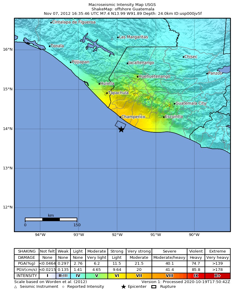
The USGS ShakeMap: shaking estimated from seismic stations and the quake’s size, on the Modified Mercalli intensity scale.
- Strongest estimated
- VII, very strong shaking
- Peak ground acceleration
- 34.1% of gravity
- Peak ground velocity
- 3.7 cm/s
- Map
- Automatic
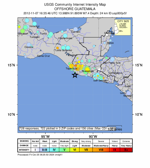
Did you feel it?
728 people reported to the USGS what they felt; the strongest reported shaking was VIII, severe shaking.
Estimated impact
The USGS PAGER system estimates deaths and economic losses from the shaking and the population and buildings exposed to it.
- Alert level
- Yellow: some damage and deaths possible, a local or regional response
| Range | Chance |
|---|---|
| Under 1 | 4% |
| 1 to 10 | 16% |
| 10 to 100 | 33% |
| 100 to 1,000 | 31% |
| 1,000 to 10,000 | 13% |
| 10,000 to 100,000 | 3% |
| 100,000 to 10,000,000 | Under 1% |
| Range, million USD | Chance |
|---|---|
| Under 1 | 3% |
| 1 to 10 | 15% |
| 10 to 100 | 32% |
| 100 to 1,000 | 32% |
| 1,000 to 10,000 | 14% |
| 10,000 to 100,000 | 3% |
| 100,000 to 10,000,000 | Under 1% |
Fault motion and ground failure
How the rock slipped, from the moment tensor, and the USGS estimate of landslides and liquefaction.
- Faulting
- Reverse (thrust)
- Nodal plane 1
- Strike 285°, dip 23°, rake 70°
- Nodal plane 2
- Strike 126°, dip 69°, rake 98°
- Landslide alert
- Green
- Liquefaction alert
- Red
How well it is located
Reviewed by a seismologist.
- Depth from
- OPERATOR_ASSIGNED
- Station coverage gap
- 26°
- Stations used
- 751
Nearest places
Distance and direction from each place to the epicenter, with its forecast.
Nearby
Within 100 km, magnitude 4.4 and up: 80 in the 60 days after this one and 6 in the 30 days before it.
After
- 4.770 km SSW of Champerico, Guatemala · 5069 days ago · 35 km deep · 43 km away
- 4.879 km SSW of Champerico, Guatemala · 5069 days ago · 35 km deep · 54 km away
- 4.723 km SE of Champerico, Guatemala · 5069 days ago · 35 km deep · 24 km away
- 4.955 km SSE of Champerico, Guatemala · 5069 days ago · 35 km deep · 25 km away
- 4.431 km SSW of Champerico, Guatemala · 5069 days ago · 35 km deep · 16 km away
- 4.724 km SSW of Champerico, Guatemala · 5069 days ago · 35 km deep · 19 km away
- 4.644 km SSW of Champerico, Guatemala · 5069 days ago · 35 km deep · 18 km away
- 5.147 km SW of Champerico, Guatemala · 5069 days ago · 27 km deep · 32 km away
- 5.755 km SSW of Champerico, Guatemala · 5069 days ago · 35 km deep · 32 km away
- 4.935 km S of Champerico, Guatemala · 5069 days ago · 35 km deep · 4 km away
- 4.544 km SSW of Ocós, Guatemala · 5069 days ago · 35 km deep · 54 km away
- 4.955 km SSW of Ocós, Guatemala · 5068 days ago · 17 km deep · 55 km away
- 4.552 km SW of Brisas Barra de Suchiate, Mexico · 5068 days ago · 43 km deep · 77 km away
- 4.835 km SSW of Ocós, Guatemala · 5068 days ago · 35 km deep · 59 km away
- 4.679 km S of Champerico, Guatemala · 5068 days ago · 35 km deep · 46 km away
- 4.476 km SSW of Ocós, Guatemala · 5067 days ago · 35 km deep · 73 km away
- 4.478 km SSW of Ocós, Guatemala · 5067 days ago · 35 km deep · 71 km away
- 4.6near the coast of Chiapas, Mexico · 5067 days ago · 35 km deep · 39 km away
- 4.4100 km SW of Champerico, Guatemala · 5067 days ago · 18 km deep · 79 km away
- 5.162 km SSW of Champerico, Guatemala · 5066 days ago · 42 km deep · 40 km away
- 4.549 km SSW of Champerico, Guatemala · 5066 days ago · 40 km deep · 29 km away
- 4.571 km SSW of Ocós, Guatemala · 5066 days ago · 6 km deep · 62 km away
- 4.452 km SSE of Champerico, Guatemala · 5065 days ago · 29 km deep · 27 km away
- 4.554 km SSE of Champerico, Guatemala · 5065 days ago · 35 km deep · 27 km away
- 4.747 km SSW of Champerico, Guatemala · 5065 days ago · 35 km deep · 24 km away
- 6.532 km SW of Champerico, Guatemala · 5065 days ago · 20 km deep · 33 km away · felt by 134
- 4.848 km SW of Champerico, Guatemala · 5065 days ago · 35 km deep · 38 km away
- 4.878 km SSW of Champerico, Guatemala · 5065 days ago · 35 km deep · 55 km away
- 4.471 km SSW of Ocós, Guatemala · 5065 days ago · 16 km deep · 69 km away
- 4.961 km SSW of Champerico, Guatemala · 5065 days ago · 35 km deep · 32 km away
- 4.472 km SW of Champerico, Guatemala · 5065 days ago · 35 km deep · 54 km away
- 4.652 km SSW of Champerico, Guatemala · 5065 days ago · 35 km deep · 27 km away
- 5.0Near the coast of Guatemala · 5065 days ago · 35 km deep · 45 km away
- 4.5near the coast of Chiapas, Mexico · 5065 days ago · 35 km deep · 44 km away
- 4.555 km SSW of Champerico, Guatemala · 5065 days ago · 35 km deep · 31 km away
- 4.646 km SW of Champerico, Guatemala · 5064 days ago · 35 km deep · 33 km away
- 4.747 km SW of Champerico, Guatemala · 5064 days ago · 35 km deep · 42 km away
- 4.568 km SSW of Champerico, Guatemala · 5064 days ago · 28 km deep · 44 km away
- 4.515 km SSE of Ocós, Guatemala · 5064 days ago · 35 km deep · 51 km away
- 4.491 km SW of Champerico, Guatemala · 5064 days ago · 24 km deep · 72 km away
- 4.580 km SW of Champerico, Guatemala · 5064 days ago · 35 km deep · 66 km away
- 4.664 km S of Champerico, Guatemala · 5063 days ago · 35 km deep · 33 km away
- 4.850 km SW of Champerico, Guatemala · 5063 days ago · 35 km deep · 40 km away
- 4.575 km SSW of Champerico, Guatemala · 5063 days ago · 35 km deep · 50 km away
- 5.093 km SW of Ocós, Guatemala · 5061 days ago · 12 km deep · 91 km away
- 4.932 km S of Champerico, Guatemala · 5061 days ago · 35 km deep · 3 km away · felt by 4
- 4.749 km SSW of Champerico, Guatemala · 5061 days ago · 35 km deep · 26 km away
- 4.484 km SSW of Ocós, Guatemala · 5060 days ago · 35 km deep · 74 km away
- 4.847 km S of Champerico, Guatemala · 5060 days ago · 35 km deep · 14 km away
- 4.461 km SSW of Ocós, Guatemala · 5059 days ago · 35 km deep · 59 km away
- 4.573 km S of Champerico, Guatemala · 5059 days ago · 28 km deep · 40 km away
- 4.562 km SW of Champerico, Guatemala · 5059 days ago · 35 km deep · 44 km away
- 4.463 km SSW of Ocós, Guatemala · 5058 days ago · 35 km deep · 56 km away
- 4.554 km SSE of Champerico, Guatemala · 5057 days ago · 35 km deep · 23 km away
- 4.463 km SW of Ocós, Guatemala · 5056 days ago · 35 km deep · 73 km away
- 4.463 km SW of Brisas Barra de Suchiate, Mexico · 5055 days ago · 106 km deep · 85 km away
- 4.455 km SW of Champerico, Guatemala · 5052 days ago · 30 km deep · 42 km away
- 4.947 km SW of Champerico, Guatemala · 5052 days ago · 35 km deep · 34 km away
- 4.670 km S of Champerico, Guatemala · 5049 days ago · 35 km deep · 37 km away
- 5.563 km SSW of Champerico, Guatemala · 5047 days ago · 10 km deep · 35 km away
The first 60 of 80.
Before
- 4.625 km SSW of Nueva Concepción, Guatemala · 5072 days ago · 73 km deep · 58 km away
- 4.464 km SW of Champerico, Guatemala · 5074 days ago · 15 km deep · 50 km away
- 4.537 km SW of Champerico, Guatemala · 5074 days ago · 37 km deep · 33 km away
- 4.420 km S of Nueva Concepción, Guatemala · 5091 days ago · 70 km deep · 65 km away
- 5.55 km ESE of La Gomera, Guatemala · 5092 days ago · 82 km deep · 96 km away · felt by 204
- 5.55 km SE of Tinajas 1ra. Sección, Mexico · 5093 days ago · 69 km deep · 88 km away · felt by 25
Earthquakes todayGuatemala earthquakesLive radar here
Sources
From the USGS Earthquake Hazards Program and its partner networks, event usp000jv5f (also filed as usb000dlwm, choy20121107163546, iscgem601879562, atlas20121107163546). Read Thu, Sep 24, 2026, 1:40 PM UTC.