M7.9 earthquake 77 km WSW of Adak, Alaska
A magnitude 7.9 earthquake struck 77 km WSW of Adak, Alaska on Sun, Jun 9, 1996, 7:03 PM HADT (04:03 UTC), 33 km (21 mi) below the surface.
Map
Where this earthquake was located, with the others nearby. Select one for its page.
The earthquake
- Magnitude
- 7.9 (mwc), major
- Local time
- UTC
- 1996-06-10 04:03:35 UTC
- Depth
- 33.0 km (20.5 mi), shallow
- Epicenter
- 51.564° N, 177.632° W
- Region
- Alaska
- Strongest shaking
- VII, very strong shaking
- Tsunami flag
- No
- Status
- Reviewed by a seismologist
Shaking
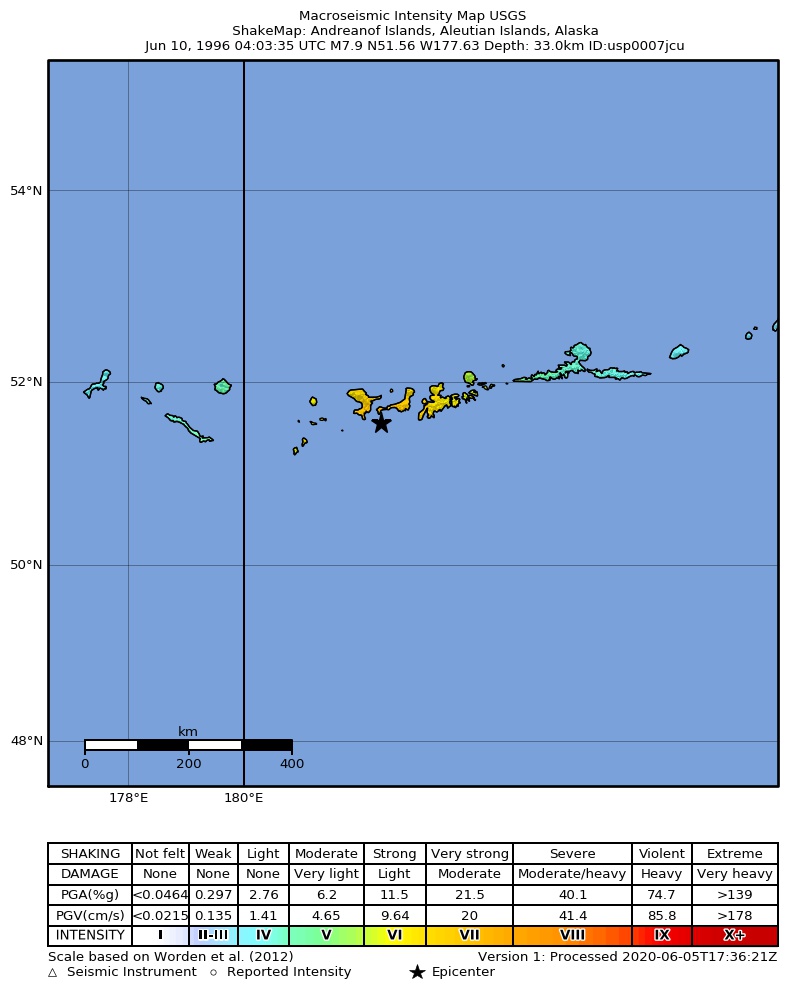
The USGS ShakeMap: shaking estimated from seismic stations and the quake’s size, on the Modified Mercalli intensity scale.
- Strongest estimated
- VII, very strong shaking
- Peak ground acceleration
- 30.8% of gravity
- Peak ground velocity
- 3.5 cm/s
- Map
- Automatic
Did you feel it?
No one has reported feeling this quake to the USGS.
Fault motion and ground failure
How the rock slipped, from the moment tensor, and the USGS estimate of landslides and liquefaction.
- Faulting
- Reverse (thrust)
- Moment magnitude
- 7.8 Mww
- Nodal plane 1
- Strike 256°, dip 21°, rake 101°
- Nodal plane 2
- Strike 63°, dip 69°, rake 85°
How well it is located
Reviewed by a seismologist.
- Depth from
- OPERATOR_ASSIGNED
Nearby
Within 100 km, magnitude 2.5 and up: 200 in the 60 days after this one and 0 in the 30 days before it.
After
- 4.388 km WSW of Adak, Alaska · 11061 days ago · 33 km deep · 12 km away
- 4.3129 km WSW of Adak, Alaska · 11061 days ago · 33 km deep · 52 km away
- 5.174 km S of Adak, Alaska · 11061 days ago · 33 km deep · 86 km away
- 5.491 km SW of Adak, Alaska · 11061 days ago · 33 km deep · 38 km away
- 4.277 km S of Adak, Alaska · 11061 days ago · 33 km deep · 70 km away
- 3.8117 km WSW of Adak, Alaska · 11061 days ago · 33 km deep · 41 km away
- 4.6110 km SW of Adak, Alaska · 11061 days ago · 33 km deep · 43 km away
- 4.296 km WSW of Adak, Alaska · 11061 days ago · 33 km deep · 20 km away
- 5.197 km SW of Adak, Alaska · 11061 days ago · 33 km deep · 45 km away
- 5.277 km SSE of Adak, Alaska · 11061 days ago · 33 km deep · 96 km away
- 5.674 km S of Adak, Alaska · 11061 days ago · 33 km deep · 89 km away
- 4.590 km S of Adak, Alaska · 11061 days ago · 33 km deep · 99 km away
- 5.0127 km WSW of Adak, Alaska · 11061 days ago · 33 km deep · 51 km away
- 4.364 km S of Adak, Alaska · 11061 days ago · 33 km deep · 77 km away
- 4.7106 km SW of Adak, Alaska · 11061 days ago · 33 km deep · 36 km away
- 4.3125 km WSW of Adak, Alaska · 11061 days ago · 33 km deep · 49 km away
- 4.9118 km WSW of Adak, Alaska · 11061 days ago · 33 km deep · 45 km away
- 4.790 km SSW of Adak, Alaska · 11061 days ago · 33 km deep · 51 km away
- 3.885 km S of Adak, Alaska · 11061 days ago · 33 km deep · 93 km away
- 4.8131 km SW of Adak, Alaska · 11061 days ago · 33 km deep · 59 km away
- 4.6129 km SW of Adak, Alaska · 11061 days ago · 33 km deep · 60 km away
- 3.997 km SW of Adak, Alaska · 11061 days ago · 33 km deep · 24 km away
- 4.189 km S of Adak, Alaska · 11061 days ago · 33 km deep · 96 km away
- 4.0151 km W of Adak, Alaska · 11061 days ago · 33 km deep · 83 km away
- 4.085 km S of Adak, Alaska · 11061 days ago · 33 km deep · 94 km away
- 4.4124 km W of Adak, Alaska · 11061 days ago · 33 km deep · 56 km away
- 4.460 km SSW of Adak, Alaska · 11061 days ago · 33 km deep · 62 km away
- 5.2118 km WSW of Adak, Alaska · 11061 days ago · 33 km deep · 43 km away
- 3.6133 km WSW of Adak, Alaska · 11061 days ago · 33 km deep · 60 km away
- 4.486 km WSW of Adak, Alaska · 11061 days ago · 33 km deep · 10 km away
- 5.049 km SSW of Adak, Alaska · 11061 days ago · 33 km deep · 58 km away
- 5.047 km SW of Adak, Alaska · 11061 days ago · 33 km deep · 40 km away
- 4.877 km SSE of Adak, Alaska · 11061 days ago · 33 km deep · 97 km away
- 5.265 km SW of Adak, Alaska · 11061 days ago · 33 km deep · 26 km away
- 3.9103 km SW of Adak, Alaska · 11061 days ago · 33 km deep · 34 km away
- 3.9131 km WSW of Adak, Alaska · 11061 days ago · 33 km deep · 56 km away
- 3.9135 km WSW of Adak, Alaska · 11061 days ago · 33 km deep · 58 km away
- 3.7122 km WSW of Adak, Alaska · 11061 days ago · 33 km deep · 45 km away
- 4.4109 km SSW of Adak, Alaska · 11061 days ago · 33 km deep · 61 km away
- 4.097 km SW of Adak, Alaska · 11061 days ago · 33 km deep · 40 km away
- 7.346 km SSW of Adak, Alaska · 11061 days ago · 26 km deep · 55 km away
- 5.577 km S of Adak, Alaska · 11061 days ago · 33 km deep · 74 km away
- 4.662 km S of Adak, Alaska · 11061 days ago · 33 km deep · 83 km away
- 3.969 km S of Adak, Alaska · 11061 days ago · 33 km deep · 83 km away
- 3.8122 km SSW of Adak, Alaska · 11061 days ago · 33 km deep · 77 km away
- 4.2151 km SW of Adak, Alaska · 11061 days ago · 33 km deep · 87 km away
- 4.285 km S of Adak, Alaska · 11061 days ago · 33 km deep · 97 km away
- 3.858 km SSW of Adak, Alaska · 11061 days ago · 33 km deep · 50 km away
- 3.747 km SSE of Adak, Alaska · 11061 days ago · 33 km deep · 87 km away
- 4.138 km S of Adak, Alaska · 11061 days ago · 33 km deep · 67 km away
- 3.9124 km WSW of Adak, Alaska · 11061 days ago · 33 km deep · 47 km away
- 4.733 km WSW of Adak, Alaska · 11061 days ago · 33 km deep · 44 km away
- 3.844 km SSE of Adak, Alaska · 11061 days ago · 33 km deep · 89 km away
- 4.467 km S of Adak, Alaska · 11061 days ago · 33 km deep · 68 km away
- 4.086 km SW of Adak, Alaska · 11061 days ago · 33 km deep · 32 km away
- 5.643 km SW of Adak, Alaska · 11061 days ago · 33 km deep · 41 km away
- 4.475 km S of Adak, Alaska · 11061 days ago · 33 km deep · 87 km away
- 4.5127 km SW of Adak, Alaska · 11061 days ago · 33 km deep · 57 km away
- 3.663 km W of Adak, Alaska · 11061 days ago · 33 km deep · 45 km away
- 4.077 km S of Adak, Alaska · 11061 days ago · 33 km deep · 93 km away
The first 60 of 200.
Earthquakes todayAlaska earthquakesLive radar here
Sources
From the USGS Earthquake Hazards Program and its partner networks, event usp0007jcu (also filed as choy19960610040335, gcmtm061096b, gcmt19960610040335, duputel061096b, ak9967fzgob5, iscgem968623, atlas19960610040336). Read Tue, Sep 22, 2026, 12:13 PM UTC.