M4.3 earthquake 70 km SSE of Akutan, Alaska
A magnitude 4.3 earthquake struck 70 km SSE of Akutan, Alaska on Thu, Aug 20, 2026, 5:11 PM AKDT (01:11 UTC), 50 km (31 mi) below the surface.
Map
Where this earthquake was located, with the others nearby. Select one for its page.
The earthquake
- Magnitude
- 4.3 (mwr), light
- Local time
- UTC
- 2026-08-21 01:11:51 UTC
- Depth
- 50.1 km (31.2 mi), shallow
- Epicenter
- 53.572° N, 165.270° W
- Region
- Alaska
- Strongest shaking
- III, weak shaking
- Tsunami flag
- No
- Status
- Reviewed by a seismologist
Shaking
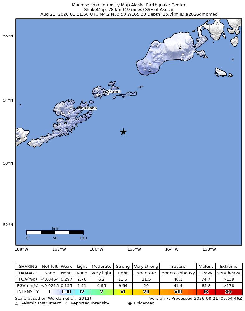
The USGS ShakeMap: shaking estimated from seismic stations and the quake’s size, on the Modified Mercalli intensity scale.
- Strongest estimated
- III, weak shaking
- Peak ground acceleration
- 0.3% of gravity
- Peak ground velocity
- 0.2 cm/s
- Map
- Automatic
Did you feel it?
No one has reported feeling this quake to the USGS.
Fault motion and ground failure
How the rock slipped, from the moment tensor, and the USGS estimate of landslides and liquefaction.
- Faulting
- Reverse (thrust)
- Moment magnitude
- 4.3 Mwr
- Nodal plane 1
- Strike 73°, dip 73°, rake 95°
- Nodal plane 2
- Strike 237°, dip 17°, rake 74°
How well it is located
Reviewed by a seismologist.
- Location uncertainty
- About 4.6 km horizontally, 6.1 km in depth
- Magnitude uncertainty
- ±0.07
- Depth from
- From location
- Station coverage gap
- 158°
- Stations used
- 82
Nearest places
Distance and direction from each place to the epicenter, with its forecast.
Nearby
Within 100 km, magnitude 1.5 and up: 96 since this one and 82 in the 30 days before it.
After
- 2.587 km SSE of Akutan, Alaska · 33 days ago · 4 km deep · 17 km away
- 2.188 km SSE of Akutan, Alaska · 33 days ago · 12 km deep · 22 km away
- 2.669 km SE of Unalaska, Alaska · 33 days ago · 27 km deep · 42 km away
- 1.940 km SE of Akutan, Alaska · 32 days ago · 74 km deep · 31 km away
- 2.397 km SSE of Akutan, Alaska · 32 days ago · 18 km deep · 31 km away
- 2.265 km E of Akutan, Alaska · 32 days ago · 74 km deep · 62 km away
- 2.528 km S of Unalaska, Alaska · 31 days ago · 84 km deep · 85 km away
- 2.4138 km SSE of Akutan, Alaska · 31 days ago · 1 km deep · 68 km away
- 2.779 km SE of Akutan, Alaska · 31 days ago · 35 km deep · 38 km away
- 2.188 km SSE of Akutan, Alaska · 30 days ago · 16 km deep · 20 km away
- 2.2101 km SSE of Akutan, Alaska · 30 days ago · 1 km deep · 31 km away
- 2.152 km SSE of Unalaska, Alaska · 29 days ago · 34 km deep · 57 km away
- 2.574 km SSE of Unalaska, Alaska · 29 days ago · 29 km deep · 78 km away
- 2.880 km SSE of Akutan, Alaska · 29 days ago · 35 km deep · 10 km away
- 2.387 km SSE of Akutan, Alaska · 29 days ago · 25 km deep · 18 km away
- 2.385 km SSE of Akutan, Alaska · 29 days ago · 28 km deep · 16 km away
- 1.625 km SSE of Unalaska, Alaska · 29 days ago · 88 km deep · 72 km away
- 2.287 km SSE of Akutan, Alaska · 29 days ago · 25 km deep · 19 km away
- 2.284 km SSE of Akutan, Alaska · 28 days ago · 28 km deep · 15 km away
- 2.496 km SSE of Akutan, Alaska · 28 days ago · 3 km deep · 25 km away
- 2.555 km SE of Akutan, Alaska · 28 days ago · 35 km deep · 24 km away
- 1.95 km SSE of Akutan, Alaska · 28 days ago · 95 km deep · 65 km away
- 2.5114 km ESE of Akutan, Alaska · 28 days ago · 22 km deep · 81 km away
- 1.965 km SSE of Akutan, Alaska · 28 days ago · 34 km deep · 6 km away
- 2.081 km ESE of Akutan, Alaska · 27 days ago · 70 km deep · 65 km away
- 2.076 km SE of Akutan, Alaska · 27 days ago · 55 km deep · 34 km away
- 2.789 km SE of Akutan, Alaska · 27 days ago · 35 km deep · 36 km away
- 2.9107 km ESE of Akutan, Alaska · 25 days ago · 35 km deep · 67 km away
- 2.6108 km ESE of Akutan, Alaska · 25 days ago · 15 km deep · 66 km away
- 2.5101 km SE of Akutan, Alaska · 25 days ago · 23 km deep · 42 km away
- 2.2107 km SE of Akutan, Alaska · 24 days ago · 5 km deep · 39 km away
- 1.739 km ESE of Unalaska, Alaska · 24 days ago · 75 km deep · 51 km away
- 2.174 km E of Akutan, Alaska · 23 days ago · 68 km deep · 65 km away
- 3.878 km SE of Akutan, Alaska · 23 days ago · 21 km deep · 24 km away
- 2.636 km S of Akutan, Alaska · 23 days ago · 67 km deep · 43 km away
- 2.6132 km SE of Unalaska, Alaska · 23 days ago · 20 km deep · 74 km away
- 2.595 km SE of Akutan, Alaska · 21 days ago · 21 km deep · 36 km away
- 2.595 km SE of Akutan, Alaska · 21 days ago · 15 km deep · 31 km away
- 2.690 km SE of Akutan, Alaska · 21 days ago · 30 km deep · 23 km away
- 2.035 km SE of Unalaska, Alaska · 20 days ago · 82 km deep · 59 km away
- 2.587 km SE of Akutan, Alaska · 19 days ago · 29 km deep · 30 km away
- 2.7108 km SE of Akutan, Alaska · 19 days ago · 4 km deep · 45 km away
- 1.87 km W of Dutch Harbor, Alaska · 19 days ago · 12 km deep · 98 km away
- 2.484 km SE of Akutan, Alaska · 19 days ago · 47 km deep · 27 km away
- 2.978 km S of Akutan, Alaska · 19 days ago · 22 km deep · 27 km away
- 1.97 km W of Dutch Harbor, Alaska · 19 days ago · 11 km deep · 98 km away
- 2.486 km E of Akutan, Alaska · 18 days ago · 17 km deep · 76 km away
- 1.76 km W of Dutch Harbor, Alaska · 18 days ago · 9 km deep · 97 km away
- 1.68 km W of Dutch Harbor, Alaska · 18 days ago · 9 km deep · 99 km away
- 2.596 km SE of Akutan, Alaska · 17 days ago · 16 km deep · 32 km away
- 2.481 km SSE of Akutan, Alaska · 17 days ago · 70 km deep · 13 km away
- 2.884 km SE of Akutan, Alaska · 16 days ago · 35 km deep · 23 km away
- 2.383 km SE of Unalaska, Alaska · 16 days ago · 19 km deep · 47 km away
- 1.949 km SSE of Unalaska, Alaska · 16 days ago · 34 km deep · 66 km away
- 2.27 km W of Dutch Harbor, Alaska · 16 days ago · 10 km deep · 98 km away
- 2.3104 km SE of Unalaska, Alaska · 16 days ago · 13 km deep · 55 km away
- 3.38 km W of Dutch Harbor, Alaska · 16 days ago · 9 km deep · 99 km away
- 1.56 km W of Dutch Harbor, Alaska · 16 days ago · 7 km deep · 97 km away
- 3.28 km W of Dutch Harbor, Alaska · 16 days ago · 11 km deep · 99 km away
- 2.08 km W of Dutch Harbor, Alaska · 16 days ago · 11 km deep · 99 km away
The first 60 of 96.
Before
- 2.383 km SE of Unalaska, Alaska · 33 days ago · 16 km deep · 29 km away
- 2.284 km SE of Unalaska, Alaska · 33 days ago · 17 km deep · 31 km away
- 2.588 km SE of Unalaska, Alaska · 34 days ago · 35 km deep · 39 km away
- 2.279 km S of Unalaska, Alaska · 34 days ago · 40 km deep · 99 km away
- 1.745 km SE of Akutan, Alaska · 34 days ago · 61 km deep · 30 km away
- 2.187 km SE of Unalaska, Alaska · 35 days ago · 26 km deep · 29 km away
- 2.021 km SSE of Akutan, Alaska · 35 days ago · 121 km deep · 49 km away
- 2.4134 km ESE of Akutan, Alaska · 35 days ago · 30 km deep · 86 km away
- 2.288 km SSE of Akutan, Alaska · 36 days ago · 21 km deep · 18 km away
- 1.748 km S of Akutan, Alaska · 36 days ago · 63 km deep · 28 km away
- 1.925 km ENE of Akutan, Alaska · 36 days ago · 86 km deep · 69 km away
- 2.5118 km SE of Akutan, Alaska · 36 days ago · 10 km deep · 57 km away
- 2.384 km SSE of Akutan, Alaska · 38 days ago · 17 km deep · 22 km away
- 2.6139 km S of False Pass, Alaska · 38 days ago · 24 km deep · 96 km away
- 2.241 km SSE of Unalaska, Alaska · 39 days ago · 72 km deep · 72 km away
- 2.628 km SE of Unalaska, Alaska · 39 days ago · 74 km deep · 63 km away
- 2.287 km SE of Unalaska, Alaska · 39 days ago · 21 km deep · 36 km away
- 2.888 km ESE of Akutan, Alaska · 40 days ago · 35 km deep · 49 km away
- 2.185 km SSE of Unalaska, Alaska · 40 days ago · 12 km deep · 62 km away
- 2.3122 km ESE of Akutan, Alaska · 40 days ago · 6 km deep · 75 km away
Earthquakes todayAlaska earthquakesLive radar here
Sources
From the USGS Earthquake Hazards Program and its partner networks, event us6000tmcf (also filed as aka2026qmpmeq). Read Wed, Sep 23, 2026, 3:35 AM UTC.