M5.3 earthquake 151 km WSW of Adak, Alaska
A magnitude 5.3 earthquake struck 151 km WSW of Adak, Alaska on Fri, Sep 11, 2026, 1:47 AM HADT (10:47 UTC), 41 km (25 mi) below the surface.
Map
Where this earthquake was located, with the others nearby. Select one for its page.
The earthquake
- Magnitude
- 5.3 (mb), moderate
- Local time
- UTC
- 2026-09-11 10:47:12 UTC
- Depth
- 40.9 km (25.4 mi), shallow
- Epicenter
- 51.213° N, 178.543° W
- Region
- Alaska
- Strongest shaking
- V, moderate shaking
- Tsunami flag
- Yes: a large quake in an oceanic region
- Status
- Reviewed by a seismologist
Tsunami
The USGS flags a quake this large in an oceanic region. The flag does not mean a tsunami happened; the tsunami warning centers decide that, and their messages are below when they issued any.
- Tsunami Information Statement from the NTWC. Read the message
Current tsunami warnings: tsunami.gov. Warnings in force in the US also appear on our alerts pages.
Shaking
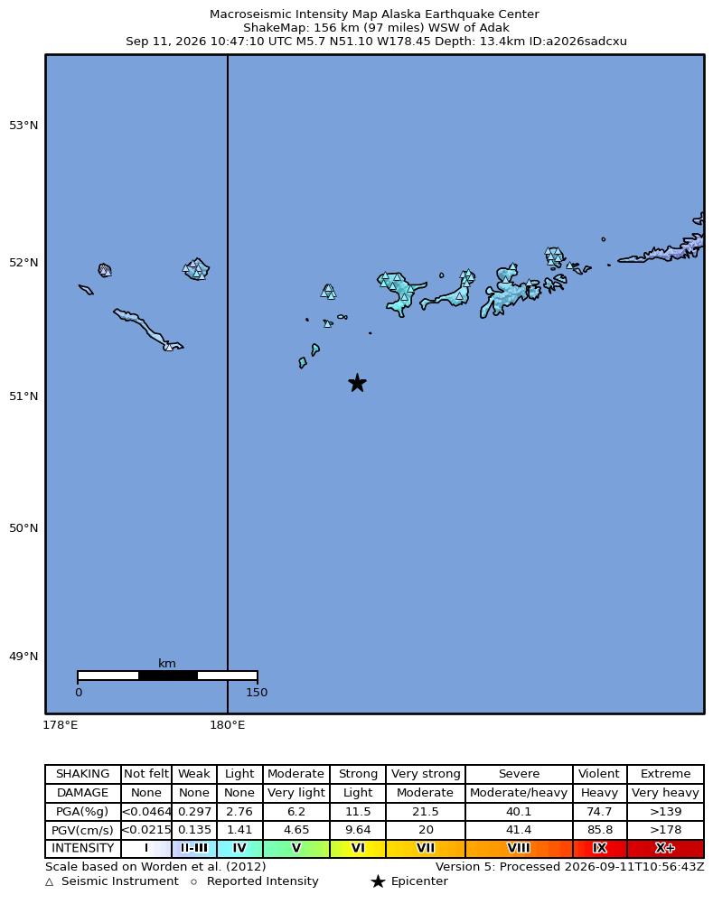
The USGS ShakeMap: shaking estimated from seismic stations and the quake’s size, on the Modified Mercalli intensity scale.
- Strongest estimated
- V, moderate shaking
- Peak ground acceleration
- 19.0% of gravity
- Peak ground velocity
- 5.7 cm/s
- Map
- Automatic
Did you feel it?
No one has reported feeling this quake to the USGS. If you felt it, tell the USGS: every report sharpens the shaking map.
Aftershock forecast
The chance of at least one aftershock this large or larger, from the USGS operational aftershock forecast, issued Tue, Sep 22, 2026, 10:47 AM UTC. The USGS updates it as the sequence unfolds.
| Within | M3+ | M4+ | M5+ | M6+ | M7+ |
|---|---|---|---|---|---|
| 1 day | 7% | Under 1% | Under 1% | Under 1% | Under 1% |
| 1 week | 30% | 4% | Under 1% | Under 1% | Under 1% |
| 1 month | 58% | 11% | 1% | Under 1% | Under 1% |
| 1 year | 85% | 27% | 3% | Under 1% | Under 1% |
In the coming week the USGS expects about 0 aftershocks of magnitude 3 or more, and most likely between 0 and 2.
How well it is located
Reviewed by a seismologist.
- Location uncertainty
- About 5.0 km horizontally, 4.6 km in depth
- Magnitude uncertainty
- ±0.02
- Depth from
- From location
- Station coverage gap
- 127°
- Stations used
- 107
Nearby
Within 100 km, magnitude 2.3 and up: 37 since this one and 76 in the 30 days before it.
After
- 3.1152 km SW of Adak, Alaska · 12 days ago · 19 km deep · 16 km away
- 4.3151 km SW of Adak, Alaska · 12 days ago · 14 km deep · 14 km away
- 3.1155 km SW of Adak, Alaska · 12 days ago · 20 km deep · 15 km away
- 2.7151 km SW of Adak, Alaska · 11 days ago · 20 km deep · 18 km away
- 2.5135 km SW of Adak, Alaska · 11 days ago · 24 km deep · 20 km away
- 2.5151 km SW of Adak, Alaska · 11 days ago · 30 km deep · 14 km away
- 2.5152 km SW of Adak, Alaska · 11 days ago · 17 km deep · 20 km away
- 2.4151 km SW of Adak, Alaska · 11 days ago · 27 km deep · 11 km away
- 2.5152 km WSW of Adak, Alaska · 11 days ago · 35 km deep · 10 km away
- 2.8214 km WSW of Adak, Alaska · 11 days ago · 17 km deep · 63 km away
- 2.6174 km W of Adak, Alaska · 11 days ago · 88 km deep · 59 km away
- 2.568 km W of Adak, Alaska · 11 days ago · 100 km deep · 91 km away
- 2.6151 km WSW of Adak, Alaska · 11 days ago · 35 km deep · 10 km away
- 2.5149 km SW of Adak, Alaska · 11 days ago · 21 km deep · 11 km away
- 2.6222 km WSW of Adak, Alaska · 11 days ago · 9 km deep · 72 km away
- 2.6150 km SW of Adak, Alaska · 11 days ago · 15 km deep · 18 km away
- 2.3149 km WSW of Adak, Alaska · 11 days ago · 26 km deep · 10 km away
- 3.5151 km SW of Adak, Alaska · 11 days ago · 19 km deep · 11 km away
- 2.4201 km WSW of Adak, Alaska · 11 days ago · 33 km deep · 58 km away
- 2.5214 km SW of Adak, Alaska · 10 days ago · 12 km deep · 65 km away
- 3.9150 km WSW of Adak, Alaska · 10 days ago · 39 km deep · 1 km away
- 2.4130 km WSW of Adak, Alaska · 10 days ago · 28 km deep · 22 km away
- 2.7123 km SW of Adak, Alaska · 10 days ago · 21 km deep · 30 km away
- 3.5134 km SW of Adak, Alaska · 10 days ago · 20 km deep · 40 km away
- 2.3158 km SW of Adak, Alaska · 9 days ago · 15 km deep · 18 km away
- 2.5162 km SW of Adak, Alaska · 8 days ago · 42 km deep · 17 km away
- 3.0134 km SW of Adak, Alaska · 8 days ago · 15 km deep · 53 km away
- 2.7243 km WSW of Adak, Alaska · 8 days ago · 9 km deep · 95 km away
- 3.1113 km SW of Adak, Alaska · 7 days ago · 35 km deep · 43 km away
- 3.4160 km WSW of Adak, Alaska · 7 days ago · 35 km deep · 24 km away
- 2.4134 km WSW of Adak, Alaska · 6 days ago · 29 km deep · 23 km away
- 3.0132 km WSW of Adak, Alaska · 6 days ago · 36 km deep · 19 km away
- 2.5135 km SW of Adak, Alaska · 6 days ago · 20 km deep · 21 km away
- 2.9125 km WSW of Adak, Alaska · 6 days ago · 11 km deep · 26 km away
- 2.8242 km SW of Adak, Alaska · 6 days ago · 5 km deep · 93 km away
- 2.4143 km SW of Adak, Alaska · 6 days ago · 33 km deep · 25 km away
- 3.5148 km WSW of Adak, Alaska · 17 hr ago · 0 km deep · 5 km away
Before
- 2.9230 km WSW of Adak, Alaska · 12 days ago · 2 km deep · 78 km away
- 2.8128 km WSW of Adak, Alaska · 12 days ago · 9 km deep · 31 km away
- 2.892 km SSW of Adak, Alaska · 12 days ago · 13 km deep · 83 km away
- 2.598 km SW of Adak, Alaska · 12 days ago · 29 km deep · 76 km away
- 2.5111 km SW of Adak, Alaska · 12 days ago · 23 km deep · 49 km away
- 2.5181 km WSW of Adak, Alaska · 13 days ago · 55 km deep · 41 km away
- 3.2155 km SW of Adak, Alaska · 13 days ago · 16 km deep · 17 km away
- 2.4195 km WSW of Adak, Alaska · 13 days ago · 64 km deep · 60 km away
- 2.4179 km SW of Adak, Alaska · 14 days ago · 19 km deep · 32 km away
- 2.5225 km WSW of Adak, Alaska · 14 days ago · 78 km deep · 94 km away
- 2.6206 km W of Adak, Alaska · 14 days ago · 91 km deep · 82 km away
- 2.6196 km WSW of Adak, Alaska · 14 days ago · 21 km deep · 46 km away
- 3.0240 km WSW of Adak, Alaska · 15 days ago · 18 km deep · 97 km away
- 2.8148 km SW of Adak, Alaska · 15 days ago · 10 km deep · 67 km away
- 2.8175 km SW of Adak, Alaska · 15 days ago · 25 km deep · 27 km away
- 3.4156 km SW of Adak, Alaska · 16 days ago · 5 km deep · 24 km away
- 2.8172 km WSW of Adak, Alaska · 16 days ago · 30 km deep · 33 km away
- 2.593 km SW of Adak, Alaska · 16 days ago · 28 km deep · 77 km away
- 2.5152 km WSW of Adak, Alaska · 17 days ago · 1 km deep · 8 km away
- 3.1219 km WSW of Adak, Alaska · 17 days ago · 18 km deep · 70 km away
Earthquakes todayAlaska earthquakesLive radar here
Sources
From the USGS Earthquake Hazards Program and its partner networks, event us7000tgky (also filed as attl74mn, aka2026sadcxu). Read Tue, Sep 22, 2026, 10:34 PM UTC.