M4.8 earthquake 26 km SW of Ackerly, Texas
A magnitude 4.8 earthquake struck 26 km SW of Ackerly, Texas on Fri, Feb 28, 2025, 1:33 PM CST (19:33 UTC), 7 km (4 mi) below the surface.
Map
Where this earthquake was located, with the others nearby. Select one for its page.
The earthquake
- Magnitude
- 4.8 (ml), light
- Local time
- UTC
- 2025-02-28 19:33:24 UTC
- Depth
- 6.8 km (4.2 mi), shallow
- Epicenter
- 32.370° N, 101.926° W
- Region
- Texas
- Felt reports
- 964
- Strongest shaking
- V, moderate shaking
- PAGER alert
- Green
- Tsunami flag
- No
- Status
- Reviewed by a seismologist
Shaking
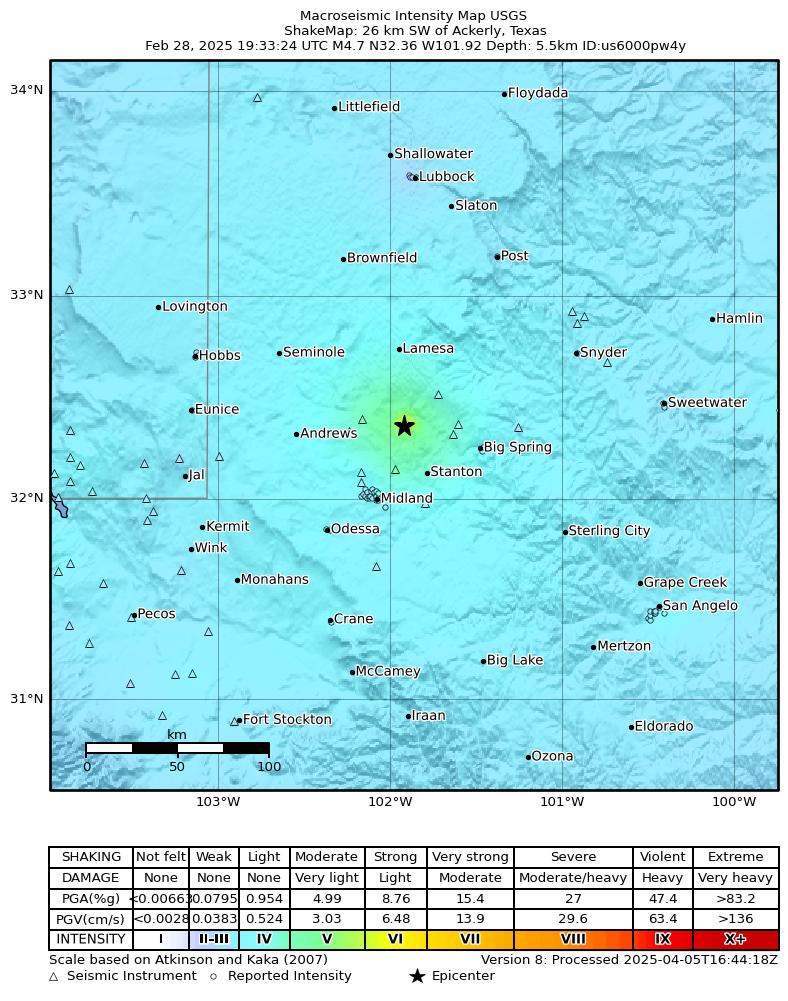
The USGS ShakeMap: shaking estimated from seismic stations and the quake’s size, on the Modified Mercalli intensity scale.
- Strongest estimated
- V, moderate shaking
- Peak ground acceleration
- 15.4% of gravity
- Peak ground velocity
- 4.6 cm/s
- Map
- Automatic
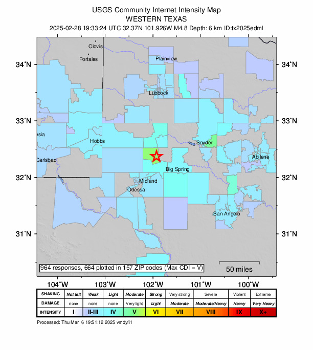
Did you feel it?
964 people reported to the USGS what they felt; the strongest reported shaking was VI, strong shaking.
Estimated impact
The USGS PAGER system estimates deaths and economic losses from the shaking and the population and buildings exposed to it.
- Alert level
- Green: little or no damage or loss of life expected
| Range | Chance |
|---|---|
| Under 1 | 65% |
| 1 to 10 | 30% |
| 10 to 100 | 4% |
| 100 to 1,000 | Under 1% |
| 1,000 to 10,000 | Under 1% |
| 10,000 to 100,000 | Under 1% |
| 100,000 to 10,000,000 | Under 1% |
| Range, million USD | Chance |
|---|---|
| Under 1 | 65% |
| 1 to 10 | 30% |
| 10 to 100 | 4% |
| 100 to 1,000 | Under 1% |
| 1,000 to 10,000 | Under 1% |
| 10,000 to 100,000 | Under 1% |
| 100,000 to 10,000,000 | Under 1% |
Aftershock forecast
The chance of at least one aftershock this large or larger, from the USGS operational aftershock forecast, issued Sat, Feb 28, 2026, 7:33 PM UTC. The USGS updates it as the sequence unfolds.
| Within | M3+ | M4+ | M5+ | M6+ | M7+ |
|---|---|---|---|---|---|
| 1 day | Under 1% | Under 1% | Under 1% | Under 1% | Under 1% |
| 1 week | Under 1% | Under 1% | Under 1% | Under 1% | Under 1% |
| 1 month | 2% | Under 1% | Under 1% | Under 1% | Under 1% |
| 1 year | 17% | 2% | Under 1% | Under 1% | Under 1% |
In the coming week the USGS expects about 0 aftershocks of magnitude 3 or more, and most likely between 0 and 0.
Fault motion and ground failure
How the rock slipped, from the moment tensor, and the USGS estimate of landslides and liquefaction.
- Faulting
- Oblique normal
- Moment magnitude
- 4.5 Mwr
- Nodal plane 1
- Strike 78°, dip 42°, rake -48°
- Nodal plane 2
- Strike 207°, dip 60°, rake -121°
- Landslide alert
- Green
- Liquefaction alert
- Green
How well it is located
Reviewed by a seismologist.
- Location uncertainty
- About 0.5 km horizontally, 1.5 km in depth
- Magnitude uncertainty
- ±0.20
- Station coverage gap
- 41°
- Stations used
- 43
Nearest places
Distance and direction from each place to the epicenter, with its forecast.
Nearby
Within 100 km, magnitude 1.8 and up: 72 in the 60 days after this one and 39 in the 30 days before it.
After
- 2.325 km SW of Ackerly, Texas · 571 days ago · 8 km deep · 1 km away · felt by 278
- 1.825 km SW of Ackerly, Texas · 571 days ago · 7 km deep · 0 km away · felt by 3
- 2.617 km SSE of Ackerly, Texas · 571 days ago · 7 km deep · 27 km away · felt by 4
- 1.835 km WSW of Ackerly, Texas · 569 days ago · 6 km deep · 14 km away
- 1.931 km WSW of Ackerly, Texas · 566 days ago · 8 km deep · 9 km away
- 1.936 km NW of Stanton, Texas · 566 days ago · 7 km deep · 13 km away
- 1.835 km WSW of Ackerly, Texas · 565 days ago · 7 km deep · 13 km away
- 2.018 km SSE of Westbrook, Texas · 564 days ago · 4 km deep · 92 km away
- 1.912 km SSE of Stanton, Texas · 563 days ago · 8 km deep · 42 km away
- 1.97 km WNW of Westbrook, Texas · 562 days ago · 8 km deep · 79 km away
- 1.936 km NW of Stanton, Texas · 560 days ago · 7 km deep · 14 km away
- 2.019 km NW of Midland, Texas · 559 days ago · 6 km deep · 37 km away
- 2.536 km SSW of Los Ybanez, Texas · 559 days ago · 7 km deep · 16 km away
- 2.420 km NW of Midland, Texas · 558 days ago · 6 km deep · 38 km away
- 2.522 km W of Garden City, Texas · 558 days ago · 8 km deep · 59 km away · felt by 1
- 1.833 km WSW of Ackerly, Texas · 557 days ago · 7 km deep · 15 km away
- 2.222 km W of Garden City, Texas · 557 days ago · 7 km deep · 59 km away
- 2.038 km NW of Stanton, Texas · 557 days ago · 7 km deep · 15 km away
- 2.638 km NW of Stanton, Texas · 556 days ago · 7 km deep · 16 km away
- 2.032 km WSW of Ackerly, Texas · 556 days ago · 8 km deep · 13 km away
- 2.338 km NW of Stanton, Texas · 555 days ago · 6 km deep · 15 km away
- 2.138 km NW of Stanton, Texas · 555 days ago · 7 km deep · 15 km away
- 2.116 km NW of Stanton, Texas · 554 days ago · 7 km deep · 15 km away · felt by 1
- 2.610 km SSW of Ackerly, Texas · 553 days ago · 7 km deep · 19 km away · felt by 1
- 1.87 km E of Midland, Texas · 553 days ago · 7 km deep · 42 km away
- 2.428 km S of Westbrook, Texas · 550 days ago · 8 km deep · 86 km away
- 2.032 km E of McKinney Acres, Texas · 550 days ago · 8 km deep · 26 km away
- 1.911 km SSE of Forsan, Texas · 549 days ago · 8 km deep · 68 km away
- 2.310 km SSE of Forsan, Texas · 548 days ago · 8 km deep · 68 km away
- 2.114 km E of Stanton, Texas · 545 days ago · 7 km deep · 39 km away
- 1.814 km WSW of Stanton, Texas · 544 days ago · 9 km deep · 34 km away
- 1.924 km SSW of Westbrook, Texas · 544 days ago · 5 km deep · 84 km away
- 2.39 km SSW of Big Spring, Texas · 542 days ago · 7 km deep · 46 km away
- 2.131 km WSW of Ackerly, Texas · 542 days ago · 9 km deep · 12 km away
- 1.823 km S of Westbrook, Texas · 542 days ago · 6 km deep · 86 km away
- 1.824 km SSW of Westbrook, Texas · 541 days ago · 8 km deep · 85 km away
- 2.323 km S of Westbrook, Texas · 541 days ago · 8 km deep · 86 km away
- 1.817 km NW of Midland, Texas · 538 days ago · 7 km deep · 38 km away
- 3.428 km SW of Garden City, Texas · 537 days ago · 10 km deep · 76 km away · felt by 1
- 1.929 km SW of Garden City, Texas · 537 days ago · 9 km deep · 75 km away
- 2.128 km SW of Garden City, Texas · 537 days ago · 8 km deep · 76 km away · felt by 1
- 2.83 km N of Stanton, Texas · 536 days ago · 8 km deep · 26 km away · felt by 6
- 2.24 km N of Stanton, Texas · 534 days ago · 8 km deep · 26 km away
- 2.610 km W of Forsan, Texas · 534 days ago · 9 km deep · 52 km away
- 1.928 km SSE of Midland, Texas · 534 days ago · 6 km deep · 66 km away
- 2.436 km SSW of Los Ybanez, Texas · 531 days ago · 6 km deep · 21 km away
- 2.735 km SSW of Los Ybanez, Texas · 529 days ago · 8 km deep · 19 km away
- 2.020 km SSE of Stanton, Texas · 528 days ago · 8 km deep · 50 km away
- 3.119 km NW of Midland, Texas · 528 days ago · 6 km deep · 38 km away · felt by 9
- 2.027 km S of Westbrook, Texas · 527 days ago · 6 km deep · 87 km away
- 1.816 km SSE of Westbrook, Texas · 526 days ago · 5 km deep · 91 km away
- 2.624 km SSW of Westbrook, Texas · 526 days ago · 7 km deep · 85 km away
- 2.57 km SSE of Midland, Texas · 525 days ago · 8 km deep · 49 km away · felt by 2
- 1.823 km NNW of Westbrook, Texas · 522 days ago · 7 km deep · 77 km away
- 1.827 km S of Westbrook, Texas · 522 days ago · 8 km deep · 86 km away
- 2.012 km WSW of Stanton, Texas · 522 days ago · 7 km deep · 29 km away
- 1.812 km WSW of Stanton, Texas · 522 days ago · 9 km deep · 29 km away
- 2.412 km W of Stanton, Texas · 521 days ago · 7 km deep · 28 km away
- 2.213 km ESE of Stanton, Texas · 520 days ago · 7 km deep · 40 km away
- 2.519 km NW of Midland, Texas · 519 days ago · 7 km deep · 37 km away · felt by 1
The first 60 of 72.
Before
- 1.834 km WSW of Ackerly, Texas · 573 days ago · 8 km deep · 13 km away
- 3.434 km WSW of Ackerly, Texas · 573 days ago · 8 km deep · 13 km away · felt by 5
- 1.819 km S of Westbrook, Texas · 574 days ago · 6 km deep · 89 km away
- 1.919 km SSW of Ackerly, Texas · 575 days ago · 6 km deep · 15 km away
- 2.735 km SSW of Los Ybanez, Texas · 575 days ago · 9 km deep · 19 km away · felt by 1
- 2.027 km NE of Crane, Texas · 576 days ago · 8 km deep · 91 km away
- 2.234 km WSW of Ackerly, Texas · 578 days ago · 8 km deep · 13 km away
- 2.314 km ESE of Stanton, Texas · 579 days ago · 6 km deep · 41 km away
- 2.117 km SE of Ackerly, Texas · 581 days ago · 5 km deep · 30 km away
- 2.25 km WSW of Westbrook, Texas · 581 days ago · 7 km deep · 80 km away
- 1.812 km SSW of Ackerly, Texas · 581 days ago · 6 km deep · 17 km away
- 2.122 km WNW of Stanton, Texas · 582 days ago · 6 km deep · 19 km away
- 1.833 km WSW of Ackerly, Texas · 584 days ago · 10 km deep · 13 km away
- 1.811 km W of Forsan, Texas · 584 days ago · 9 km deep · 51 km away
- 1.823 km W of Garden City, Texas · 585 days ago · 7 km deep · 57 km away
- 2.223 km W of Garden City, Texas · 585 days ago · 8 km deep · 57 km away · felt by 10
- 2.630 km SSW of Los Ybanez, Texas · 585 days ago · 7 km deep · 15 km away · felt by 42
- 2.39 km NNE of West Odessa, Texas · 585 days ago · 6 km deep · 71 km away · felt by 1
- 1.817 km SE of Ackerly, Texas · 587 days ago · 5 km deep · 30 km away
- 1.818 km SSE of Ackerly, Texas · 588 days ago · 8 km deep · 30 km away
Earthquakes todayTexas earthquakesLive radar here
Sources
From the USGS Earthquake Hazards Program and its partner networks, event tx2025edml (also filed as us6000pw4y). Read Tue, Sep 22, 2026, 9:05 PM UTC.