M3.4 earthquake 34 km WSW of Ackerly, Texas
A magnitude 3.4 earthquake struck 34 km WSW of Ackerly, Texas on Fri, Oct 18, 2024, 1:24 PM CDT (18:24 UTC), 7 km (4 mi) below the surface.
Map
Where this earthquake was located, with the others nearby. Select one for its page.
The earthquake
- Magnitude
- 3.4 (ml), minor
- Local time
- UTC
- 2024-10-18 18:24:19 UTC
- Depth
- 7.2 km (4.5 mi), shallow
- Epicenter
- 32.411° N, 102.061° W
- Region
- Texas
- Felt reports
- 2
- Tsunami flag
- No
- Status
- Reviewed by a seismologist
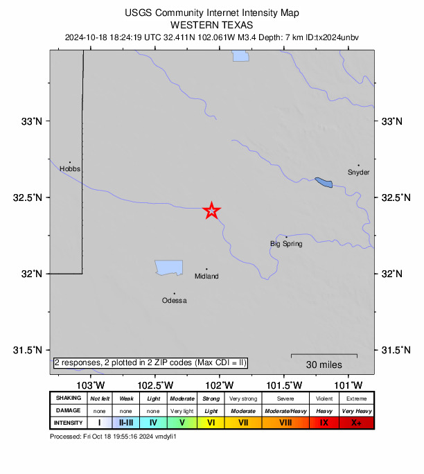
Did you feel it?
2 people reported to the USGS what they felt; the strongest reported shaking was II, weak shaking.
Fault motion and ground failure
How the rock slipped, from the moment tensor, and the USGS estimate of landslides and liquefaction.
- Faulting
- Normal
- Moment magnitude
- 3.3 Mwr
- Nodal plane 1
- Strike 90°, dip 55°, rake -60°
- Nodal plane 2
- Strike 225°, dip 45°, rake -126°
How well it is located
Reviewed by a seismologist.
- Location uncertainty
- About 0.5 km horizontally, 0.6 km in depth
- Magnitude uncertainty
- ±0.20
- Station coverage gap
- 68°
- Stations used
- 17
Nearest places
Distance and direction from each place to the epicenter, with its forecast.
Nearby
Within 100 km, magnitude 1.5 and up: 116 in the 60 days after this one and 70 in the 30 days before it.
After
- 3.134 km WSW of Ackerly, Texas · 705 days ago · 6 km deep · 0 km away
- 1.635 km WSW of Ackerly, Texas · 705 days ago · 7 km deep · 1 km away
- 1.934 km WSW of Ackerly, Texas · 705 days ago · 6 km deep · 1 km away
- 1.813 km NNW of Garden City, Texas · 705 days ago · 8 km deep · 69 km away
- 2.035 km WSW of Ackerly, Texas · 704 days ago · 7 km deep · 1 km away
- 1.928 km ESE of Midland, Texas · 703 days ago · 8 km deep · 66 km away
- 1.75 km WSW of Westbrook, Texas · 703 days ago · 6 km deep · 93 km away
- 1.834 km WSW of Ackerly, Texas · 703 days ago · 7 km deep · 0 km away · felt by 1
- 1.529 km SE of Midland, Texas · 702 days ago · 5 km deep · 67 km away · felt by 1
- 1.58 km E of Coahoma, Texas · 702 days ago · 7 km deep · 81 km away
- 1.720 km NW of Stanton, Texas · 702 days ago · 8 km deep · 20 km away
- 1.65 km SE of Midland, Texas · 702 days ago · 8 km deep · 51 km away
- 2.135 km WSW of Ackerly, Texas · 702 days ago · 7 km deep · 1 km away
- 1.536 km WSW of Ackerly, Texas · 701 days ago · 7 km deep · 3 km away
- 2.223 km S of Westbrook, Texas · 701 days ago · 9 km deep · 99 km away
- 2.524 km SSW of Westbrook, Texas · 701 days ago · 8 km deep · 98 km away · felt by 1
- 1.523 km SSW of Westbrook, Texas · 701 days ago · 3 km deep · 98 km away
- 1.625 km E of Forsan, Texas · 700 days ago · 6 km deep · 95 km away
- 1.516 km SE of Stanton, Texas · 700 days ago · 9 km deep · 57 km away
- 1.833 km WSW of Ackerly, Texas · 699 days ago · 8 km deep · 1 km away
- 1.61 km SE of Gardendale, Texas · 697 days ago · 5 km deep · 53 km away
- 1.56 km WNW of Westbrook, Texas · 697 days ago · 7 km deep · 93 km away
- 1.68 km SE of Midland, Texas · 696 days ago · 8 km deep · 52 km away
- 2.415 km NE of Jal, New Mexico · 695 days ago · 5 km deep · 99 km away
- 1.835 km WSW of Ackerly, Texas · 694 days ago · 7 km deep · 1 km away
- 1.99 km SSE of Ackerly, Texas · 694 days ago · 7 km deep · 35 km away · felt by 1
- 1.911 km SSW of Forsan, Texas · 694 days ago · 9 km deep · 77 km away
- 1.58 km E of Coahoma, Texas · 694 days ago · 6 km deep · 80 km away
- 1.723 km SSW of Westbrook, Texas · 693 days ago · 8 km deep · 98 km away
- 1.635 km WSW of Ackerly, Texas · 692 days ago · 7 km deep · 1 km away
- 1.923 km SE of Coahoma, Texas · 691 days ago · 7 km deep · 93 km away
- 1.723 km SE of Coahoma, Texas · 691 days ago · 8 km deep · 93 km away
- 1.623 km S of Westbrook, Texas · 690 days ago · 3 km deep · 99 km away
- 1.514 km SSE of Stanton, Texas · 690 days ago · 5 km deep · 54 km away
- 1.724 km SSW of Westbrook, Texas · 690 days ago · 4 km deep · 97 km away
- 3.021 km NNW of Stanton, Texas · 689 days ago · 6 km deep · 23 km away · felt by 1
- 1.513 km NW of Garden City, Texas · 689 days ago · 4 km deep · 68 km away
- 2.216 km NW of Stanton, Texas · 688 days ago · 7 km deep · 24 km away
- 2.032 km SSW of Los Ybanez, Texas · 688 days ago · 8 km deep · 5 km away
- 1.623 km S of Westbrook, Texas · 686 days ago · 9 km deep · 99 km away
- 1.62 km SSE of Coahoma, Texas · 685 days ago · 8 km deep · 73 km away · felt by 1
- 2.023 km S of Westbrook, Texas · 684 days ago · 8 km deep · 99 km away
- 1.924 km E of Forsan, Texas · 682 days ago · 8 km deep · 95 km away
- 1.524 km E of Forsan, Texas · 682 days ago · 8 km deep · 95 km away
- 2.333 km SSW of Los Ybanez, Texas · 682 days ago · 9 km deep · 3 km away
- 1.920 km NNW of Stanton, Texas · 681 days ago · 6 km deep · 23 km away
- 1.537 km ENE of McKinney Acres, Texas · 680 days ago · 6 km deep · 8 km away
- 2.424 km S of Westbrook, Texas · 679 days ago · 9 km deep · 99 km away
- 1.67 km WNW of Sand Springs, Texas · 679 days ago · 7 km deep · 61 km away · felt by 1
- 1.836 km WSW of Ackerly, Texas · 679 days ago · 7 km deep · 2 km away
- 2.123 km S of Westbrook, Texas · 678 days ago · 3 km deep · 99 km away
- 2.623 km S of Westbrook, Texas · 678 days ago · 6 km deep · 99 km away
- 2.716 km NW of Stanton, Texas · 678 days ago · 7 km deep · 24 km away
- 1.824 km E of Forsan, Texas · 678 days ago · 7 km deep · 95 km away
- 2.025 km E of Forsan, Texas · 678 days ago · 5 km deep · 96 km away
- 1.523 km S of Westbrook, Texas · 678 days ago · 6 km deep · 99 km away
- 1.534 km WSW of Ackerly, Texas · 678 days ago · 7 km deep · 0 km away
- 2.07 km SE of Midland, Texas · 675 days ago · 9 km deep · 53 km away
- 1.536 km WSW of Ackerly, Texas · 674 days ago · 9 km deep · 2 km away
- 2.620 km NNW of Stanton, Texas · 674 days ago · 6 km deep · 24 km away · felt by 2
The first 60 of 116.
Before
- 1.734 km WSW of Ackerly, Texas · 705 days ago · 8 km deep · 0 km away
- 1.535 km WSW of Ackerly, Texas · 706 days ago · 7 km deep · 1 km away
- 2.314 km S of Ackerly, Texas · 707 days ago · 6 km deep · 33 km away
- 1.68 km SE of Gardendale, Texas · 707 days ago · 8 km deep · 54 km away
- 2.436 km WSW of Ackerly, Texas · 708 days ago · 9 km deep · 1 km away
- 1.635 km WSW of Ackerly, Texas · 708 days ago · 9 km deep · 1 km away
- 1.710 km SSE of Forsan, Texas · 709 days ago · 5 km deep · 81 km away
- 2.016 km NNW of Midland, Texas · 710 days ago · 8 km deep · 33 km away · felt by 1
- 2.115 km NNW of Midland, Texas · 710 days ago · 8 km deep · 34 km away · felt by 1
- 2.226 km SW of Garden City, Texas · 711 days ago · 9 km deep · 84 km away
- 1.527 km NE of Crane, Texas · 712 days ago · 9 km deep · 94 km away
- 1.82 km ESE of Gardendale, Texas · 712 days ago · 3 km deep · 52 km away
- 1.62 km SSE of Gardendale, Texas · 712 days ago · 10 km deep · 54 km away
- 1.611 km SSE of Forsan, Texas · 713 days ago · 9 km deep · 81 km away
- 1.533 km WSW of Ackerly, Texas · 713 days ago · 8 km deep · 2 km away
- 1.833 km WSW of Ackerly, Texas · 713 days ago · 9 km deep · 1 km away · felt by 1
- 1.833 km WSW of Ackerly, Texas · 713 days ago · 8 km deep · 2 km away
- 1.727 km E of Forsan, Texas · 714 days ago · 8 km deep · 99 km away
- 2.037 km NW of Stanton, Texas · 714 days ago · 8 km deep · 7 km away
- 1.724 km SSW of Westbrook, Texas · 714 days ago · 4 km deep · 98 km away
Earthquakes todayTexas earthquakesLive radar here
Sources
From the USGS Earthquake Hazards Program and its partner networks, event tx2024unbv (also filed as us6000nzla). Read Wed, Sep 23, 2026, 11:31 PM UTC.