M4.1 earthquake 20 km N of Stanton, Texas
A magnitude 4.1 earthquake struck 20 km N of Stanton, Texas on Sat, Nov 4, 2023, 6:39 PM CDT (23:39 UTC), 7 km (4 mi) below the surface.
A larger quake followed: M4.2 31 km WSW of Ackerly, Texas. This one was a foreshock.
Map
Where this earthquake was located, with the others nearby. Select one for its page.
The earthquake
- Magnitude
- 4.1 (ml(texnet)), light
- Local time
- UTC
- 2023-11-04 23:39:55 UTC
- Depth
- 6.7 km (4.2 mi), shallow
- Epicenter
- 32.312° N, 101.828° W
- Region
- Texas
- Felt reports
- 24
- Strongest shaking
- V, moderate shaking
- PAGER alert
- Green
- Tsunami flag
- No
- Status
- Reviewed by a seismologist
Shaking
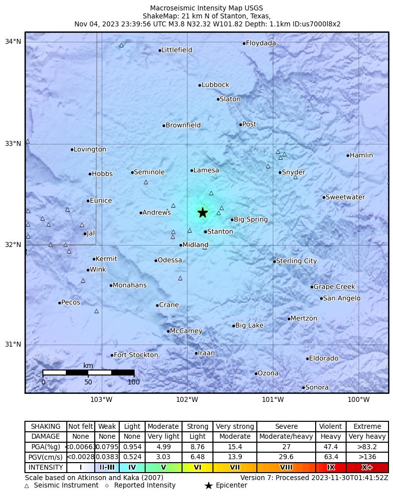
The USGS ShakeMap: shaking estimated from seismic stations and the quake’s size, on the Modified Mercalli intensity scale.
- Strongest estimated
- V, moderate shaking
- Peak ground acceleration
- 11.0% of gravity
- Peak ground velocity
- 3.7 cm/s
- Map
- Automatic
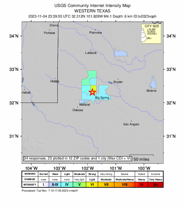
Did you feel it?
24 people reported to the USGS what they felt; the strongest reported shaking was VIII, severe shaking.
Estimated impact
The USGS PAGER system estimates deaths and economic losses from the shaking and the population and buildings exposed to it.
- Alert level
- Green: little or no damage or loss of life expected
| Range | Chance |
|---|---|
| Under 1 | 65% |
| 1 to 10 | 30% |
| 10 to 100 | 4% |
| 100 to 1,000 | Under 1% |
| 1,000 to 10,000 | Under 1% |
| 10,000 to 100,000 | Under 1% |
| 100,000 to 10,000,000 | Under 1% |
| Range, million USD | Chance |
|---|---|
| Under 1 | 65% |
| 1 to 10 | 30% |
| 10 to 100 | 4% |
| 100 to 1,000 | Under 1% |
| 1,000 to 10,000 | Under 1% |
| 10,000 to 100,000 | Under 1% |
| 100,000 to 10,000,000 | Under 1% |
Fault motion and ground failure
How the rock slipped, from the moment tensor, and the USGS estimate of landslides and liquefaction.
- Faulting
- Normal
- Nodal plane 1
- Strike 99°, dip 46°, rake -69°
- Nodal plane 2
- Strike 250°, dip 48°, rake -110°
How well it is located
Reviewed by a seismologist.
- Location uncertainty
- About 0.4 km horizontally, 0.6 km in depth
- Magnitude uncertainty
- ±0.30
- Station coverage gap
- 45°
- Stations used
- 30
Nearest places
Distance and direction from each place to the epicenter, with its forecast.
Nearby
Within 100 km, magnitude 1.5 and up: 104 in the 60 days after this one and 24 in the 30 days before it.
After
- 2.420 km N of Stanton, Texas · 1053 days ago · 8 km deep · 1 km away
- 2.820 km N of Stanton, Texas · 1053 days ago · 6 km deep · 0 km away · felt by 3
- 4.120 km N of Stanton, Texas · 1053 days ago · 7 km deep · 0 km away · felt by 15
- 1.525 km S of Westbrook, Texas · 1052 days ago · 6 km deep · 76 km away
- 1.820 km N of Stanton, Texas · 1052 days ago · 7 km deep · 0 km away
- 1.69 km NNW of Forsan, Texas · 1052 days ago · 6 km deep · 43 km away
- 2.218 km NW of Stanton, Texas · 1052 days ago · 8 km deep · 10 km away
- 1.637 km NW of Stanton, Texas · 1051 days ago · 8 km deep · 25 km away
- 1.819 km NNW of Stanton, Texas · 1050 days ago · 9 km deep · 1 km away
- 2.12 km NNW of Garden City, Texas · 1048 days ago · 10 km deep · 57 km away
- 2.620 km N of Stanton, Texas · 1047 days ago · 6 km deep · 0 km away · felt by 3
- 2.420 km N of Stanton, Texas · 1046 days ago · 6 km deep · 0 km away
- 2.025 km S of Westbrook, Texas · 1046 days ago · 8 km deep · 77 km away
- 1.94 km S of Sand Springs, Texas · 1046 days ago · 8 km deep · 45 km away
- 1.8western Texas · 1045 days ago · 8 km deep · 19 km away
- 3.522 km WNW of Stanton, Texas · 1045 days ago · 9 km deep · 19 km away · felt by 11
- 1.823 km WNW of Stanton, Texas · 1045 days ago · 8 km deep · 20 km away
- 1.523 km WNW of Stanton, Texas · 1045 days ago · 8 km deep · 20 km away
- 1.722 km WNW of Stanton, Texas · 1045 days ago · 8 km deep · 19 km away
- 1.528 km SSE of Midland, Texas · 1045 days ago · 9 km deep · 61 km away
- 1.523 km WNW of Stanton, Texas · 1045 days ago · 6 km deep · 20 km away
- 1.625 km NW of Westbrook, Texas · 1045 days ago · 6 km deep · 63 km away
- 2.022 km WNW of Stanton, Texas · 1044 days ago · 9 km deep · 20 km away
- 2.032 km SSW of Los Ybanez, Texas · 1044 days ago · 7 km deep · 29 km away
- 1.617 km ESE of Stanton, Texas · 1044 days ago · 13 km deep · 33 km away
- 2.636 km SSW of Los Ybanez, Texas · 1044 days ago · 8 km deep · 30 km away
- 1.623 km WNW of Stanton, Texas · 1044 days ago · 7 km deep · 20 km away
- 2.037 km NW of Stanton, Texas · 1043 days ago · 7 km deep · 25 km away
- 1.936 km SSW of Los Ybanez, Texas · 1043 days ago · 9 km deep · 31 km away
- 1.923 km WNW of Stanton, Texas · 1042 days ago · 8 km deep · 20 km away
- 1.825 km S of Westbrook, Texas · 1041 days ago · 3 km deep · 78 km away
- 2.723 km E of Forsan, Texas · 1040 days ago · 5 km deep · 70 km away · felt by 4
- 2.617 km NW of Midland, Texas · 1040 days ago · 7 km deep · 43 km away · felt by 7
- 1.818 km N of Stanton, Texas · 1040 days ago · 6 km deep · 3 km away
- 1.95 km SSE of Midland, Texas · 1039 days ago · 8 km deep · 45 km away
- 2.122 km WNW of Stanton, Texas · 1037 days ago · 9 km deep · 19 km away
- 1.928 km SE of Midland, Texas · 1036 days ago · 7 km deep · 59 km away
- 1.69 km ESE of Midland, Texas · 1036 days ago · 6 km deep · 40 km away
- 2.039 km ENE of McKinney Acres, Texas · 1035 days ago · 8 km deep · 28 km away
- 4.231 km WSW of Ackerly, Texas · 1034 days ago · 8 km deep · 21 km away · felt by 5
- 2.27 km SE of Gardendale, Texas · 1034 days ago · 7 km deep · 59 km away
- 2.132 km WSW of Ackerly, Texas · 1034 days ago · 8 km deep · 23 km away
- 2.231 km WSW of Ackerly, Texas · 1034 days ago · 8 km deep · 21 km away
- 1.831 km WSW of Ackerly, Texas · 1034 days ago · 7 km deep · 22 km away
- 1.838 km WSW of Ackerly, Texas · 1034 days ago · 9 km deep · 27 km away
- 2.0western Texas · 1034 days ago · 9 km deep · 22 km away
- 1.88 km SE of Gardendale, Texas · 1034 days ago · 8 km deep · 59 km away
- 2.3western Texas · 1033 days ago · 8 km deep · 23 km away
- 1.516 km NNW of Midland, Texas · 1033 days ago · 7 km deep · 38 km away
- 1.515 km NNW of Midland, Texas · 1033 days ago · 7 km deep · 38 km away
- 2.128 km SSW of Los Ybanez, Texas · 1032 days ago · 10 km deep · 26 km away
- 2.6western Texas · 1032 days ago · 15 km deep · 25 km away · felt by 2
- 2.125 km S of Westbrook, Texas · 1031 days ago · 9 km deep · 76 km away
- 1.611 km WNW of Stanton, Texas · 1031 days ago · 7 km deep · 17 km away
- 1.725 km S of Westbrook, Texas · 1031 days ago · 6 km deep · 76 km away
- 1.626 km S of Westbrook, Texas · 1031 days ago · 8 km deep · 76 km away
- 2.032 km WSW of Ackerly, Texas · 1030 days ago · 7 km deep · 23 km away
- 1.520 km N of Stanton, Texas · 1030 days ago · 8 km deep · 0 km away
- 3.031 km WSW of Ackerly, Texas · 1030 days ago · 9 km deep · 22 km away
- 1.510 km E of Coahoma, Texas · 1028 days ago · 7 km deep · 59 km away
The first 60 of 104.
Before
- 2.022 km WNW of Stanton, Texas · 1053 days ago · 8 km deep · 19 km away
- 2.731 km NE of Andrews, Texas · 1055 days ago · 4 km deep · 48 km away
- 2.418 km SE of Ackerly, Texas · 1055 days ago · 4 km deep · 25 km away
- 3.318 km SE of Ackerly, Texas · 1055 days ago · 4 km deep · 25 km away · felt by 2
- 3.322 km WNW of Stanton, Texas · 1055 days ago · 8 km deep · 19 km away · felt by 5
- 2.923 km WNW of Stanton, Texas · 1056 days ago · 9 km deep · 19 km away · felt by 1
- 1.532 km WSW of Ackerly, Texas · 1056 days ago · 8 km deep · 22 km away
- 2.028 km SSW of Los Ybanez, Texas · 1056 days ago · 9 km deep · 26 km away
- 2.124 km NW of Westbrook, Texas · 1059 days ago · 7 km deep · 62 km away
- 1.939 km N of Midland, Texas · 1059 days ago · 9 km deep · 27 km away
- 2.226 km S of Westbrook, Texas · 1060 days ago · 9 km deep · 76 km away
- 2.132 km SSW of Los Ybanez, Texas · 1070 days ago · 9 km deep · 28 km away
- 1.827 km S of Westbrook, Texas · 1073 days ago · 4 km deep · 75 km away
- 1.823 km S of Westbrook, Texas · 1073 days ago · 0 km deep · 76 km away
- 1.825 km S of Westbrook, Texas · 1074 days ago · 6 km deep · 76 km away
- 2.125 km S of Westbrook, Texas · 1074 days ago · 8 km deep · 77 km away
- 1.510 km E of Coahoma, Texas · 1076 days ago · 6 km deep · 59 km away
- 2.87 km WSW of Westbrook, Texas · 1076 days ago · 12 km deep · 70 km away
- 1.619 km N of Stanton, Texas · 1078 days ago · 7 km deep · 1 km away
- 2.21 km NNW of Garden City, Texas · 1078 days ago · 9 km deep · 58 km away
Earthquakes todayTexas earthquakesLive radar here
Sources
From the USGS Earthquake Hazards Program and its partner networks, event tx2023vqsh (also filed as us7000l8x2). Read Wed, Sep 23, 2026, 12:52 AM UTC.