M2.6 earthquake 22 km NNW of Midland, Texas
A magnitude 2.6 earthquake struck 22 km NNW of Midland, Texas on Fri, Dec 16, 2022, 10:59 PM CST (04:59 UTC), 8 km (5 mi) below the surface.
A larger quake followed: M3.1 9 km SE of Midland, Texas. This one was a foreshock.
Map
Where this earthquake was located, with the others nearby. Select one for its page.
The earthquake
- Magnitude
- 2.6 (ml), micro
- Local time
- UTC
- 2022-12-17 04:59:20 UTC
- Depth
- 8.0 km (5.0 mi), shallow
- Epicenter
- 32.196° N, 102.160° W
- Region
- Texas
- Felt reports
- 15
- Tsunami flag
- No
- Status
- Reviewed by a seismologist
Did you feel it?
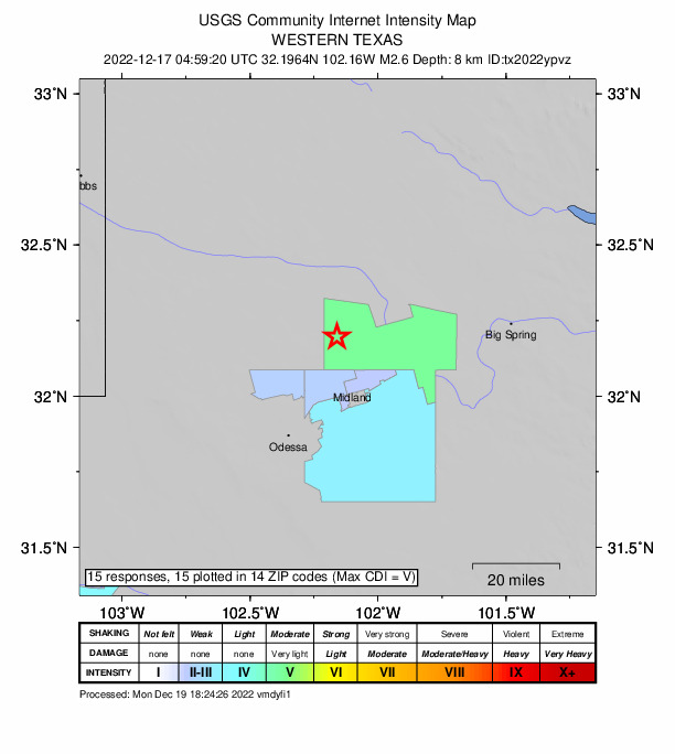
15 people reported to the USGS what they felt; the strongest reported shaking was V, moderate shaking.
How well it is located
Reviewed by a seismologist.
- Location uncertainty
- About 0.8 km horizontally, 1.8 km in depth
- Magnitude uncertainty
- ±0.20
- Station coverage gap
- 70°
- Stations used
- 18
Nearest places
Distance and direction from each place to the epicenter, with its forecast.
Nearby
Within 100 km, magnitude 1.5 and up: 60 in the 60 days after this one and 15 in the 30 days before it.
After
- 3.19 km SE of Midland, Texas · 1374 days ago · 10 km deep · 32 km away · felt by 13
- 2.311 km SE of Midland, Texas · 1374 days ago · 1 km deep · 34 km away
- 2.323 km NNW of Midland, Texas · 1374 days ago · 6 km deep · 0 km away
- 1.823 km NNW of Midland, Texas · 1373 days ago · 8 km deep · 2 km away
- 1.712 km SSE of Midland, Texas · 1372 days ago · 0 km deep · 36 km away
- 3.2western Texas · 1372 days ago · 8 km deep · 10 km away · felt by 35
- 3.416 km NW of Stanton, Texas · 1368 days ago · 6 km deep · 26 km away · felt by 3
- 1.75 km SE of Midland, Texas · 1366 days ago · 9 km deep · 29 km away
- 3.613 km NE of Jal, New Mexico · 1366 days ago · 9 km deep · 88 km away · felt by 8
- 2.233 km NE of McKinney Acres, Texas · 1359 days ago · 2 km deep · 34 km away
- 1.529 km SSW of Los Ybanez, Texas · 1358 days ago · 6 km deep · 33 km away
- 1.523 km NNW of Midland, Texas · 1357 days ago · 7 km deep · 2 km away
- 2.020 km N of Stanton, Texas · 1356 days ago · 6 km deep · 34 km away
- 1.721 km N of Stanton, Texas · 1355 days ago · 6 km deep · 34 km away
- 1.823 km NNW of Midland, Texas · 1355 days ago · 8 km deep · 2 km away
- 2.422 km NNW of Midland, Texas · 1353 days ago · 12 km deep · 3 km away
- 2.08 km ENE of Gardendale, Texas · 1352 days ago · 8 km deep · 21 km away
- 2.628 km SSW of Los Ybanez, Texas · 1351 days ago · 9 km deep · 34 km away
- 1.67 km E of Gardendale, Texas · 1350 days ago · 9 km deep · 22 km away
- 1.621 km NNW of Stanton, Texas · 1350 days ago · 6 km deep · 34 km away
- 1.722 km N of Stanton, Texas · 1349 days ago · 6 km deep · 34 km away
- 1.915 km ESE of Stanton, Texas · 1349 days ago · 9 km deep · 51 km away
- 1.829 km WSW of Ackerly, Texas · 1347 days ago · 9 km deep · 33 km away
- 1.623 km N of Midland, Texas · 1346 days ago · 10 km deep · 10 km away
- 1.923 km NNW of Midland, Texas · 1344 days ago · 8 km deep · 2 km away
- 1.510 km ENE of Gardendale, Texas · 1344 days ago · 9 km deep · 20 km away
- 1.721 km NNW of Midland, Texas · 1344 days ago · 10 km deep · 2 km away
- 1.56 km SSE of Midland, Texas · 1344 days ago · 9 km deep · 30 km away
- 1.726 km NW of Westbrook, Texas · 1344 days ago · 8 km deep · 97 km away
- 1.8western Texas · 1343 days ago · 8 km deep · 14 km away
- 1.67 km SSE of Midland, Texas · 1341 days ago · 8 km deep · 31 km away
- 2.538 km SSW of Los Ybanez, Texas · 1340 days ago · 9 km deep · 24 km away
- 2.716 km NE of Jal, New Mexico · 1339 days ago · 15 km deep · 87 km away
- 1.95 km SSE of Midland, Texas · 1339 days ago · 9 km deep · 29 km away
- 1.721 km NW of Stanton, Texas · 1339 days ago · 5 km deep · 22 km away
- 1.913 km SSE of Ackerly, Texas · 1337 days ago · 10 km deep · 51 km away
- 1.616 km SSE of Ackerly, Texas · 1335 days ago · 6 km deep · 55 km away
- 2.17 km SSE of Midland, Texas · 1334 days ago · 10 km deep · 31 km away
- 1.76 km SE of Ackerly, Texas · 1332 days ago · 12 km deep · 56 km away
- 2.65 km SE of Ackerly, Texas · 1332 days ago · 9 km deep · 56 km away
- 1.86 km SE of Gardendale, Texas · 1329 days ago · 7 km deep · 29 km away
- 2.332 km SSW of Los Ybanez, Texas · 1328 days ago · 11 km deep · 30 km away
- 2.117 km SSE of Ackerly, Texas · 1327 days ago · 7 km deep · 55 km away
- 3.120 km NW of Stanton, Texas · 1327 days ago · 8 km deep · 23 km away
- 1.78 km S of Ackerly, Texas · 1326 days ago · 9 km deep · 51 km away
- 2.3western Texas · 1325 days ago · 6 km deep · 12 km away · felt by 4
- 1.911 km N of Midland, Texas · 1325 days ago · 7 km deep · 12 km away · felt by 1
- 1.52 km SSE of Coahoma, Texas · 1325 days ago · 7 km deep · 82 km away
- 1.616 km SSE of Ackerly, Texas · 1324 days ago · 8 km deep · 55 km away
- 1.732 km SSW of Los Ybanez, Texas · 1324 days ago · 8 km deep · 30 km away
- 2.016 km SSE of Ackerly, Texas · 1323 days ago · 9 km deep · 55 km away
- 1.717 km SSE of Ackerly, Texas · 1323 days ago · 7 km deep · 54 km away
- 2.024 km NW of Westbrook, Texas · 1323 days ago · 7 km deep · 99 km away
- 2.036 km SSW of Los Ybanez, Texas · 1323 days ago · 11 km deep · 27 km away
- 2.213 km NNE of Midland, Texas · 1319 days ago · 8 km deep · 14 km away
- 2.036 km SSW of Los Ybanez, Texas · 1318 days ago · 9 km deep · 27 km away
- 1.822 km NNW of Midland, Texas · 1318 days ago · 8 km deep · 1 km away
- 1.513 km ESE of Stanton, Texas · 1317 days ago · 10 km deep · 49 km away
- 1.713 km ESE of Stanton, Texas · 1317 days ago · 9 km deep · 50 km away
- 2.913 km NNW of Midland, Texas · 1316 days ago · 8 km deep · 10 km away · felt by 10
Before
- 2.623 km NNW of Midland, Texas · 1376 days ago · 8 km deep · 2 km away · felt by 5
- 1.8western Texas · 1376 days ago · 8 km deep · 0 km away · felt by 3
- 3.421 km NNW of Midland, Texas · 1376 days ago · 7 km deep · 3 km away · felt by 42
- 5.2Range Hill, Texas · 1376 days ago · 8 km deep · 2 km away · felt by 2,405
- 2.917 km N of Stanton, Texas · 1378 days ago · 10 km deep · 36 km away
- 2.1western Texas · 1387 days ago · 8 km deep · 20 km away
- 3.035 km SSW of Los Ybanez, Texas · 1390 days ago · 10 km deep · 27 km away
- 1.817 km NE of Jal, New Mexico · 1397 days ago · 0 km deep · 86 km away
- 2.635 km SSW of Los Ybanez, Texas · 1397 days ago · 9 km deep · 27 km away
- 2.3western Texas · 1398 days ago · 11 km deep · 31 km away
- 2.2western Texas · 1398 days ago · 10 km deep · 31 km away
- 1.64 km SE of Gardendale, Texas · 1399 days ago · 8 km deep · 30 km away
- 2.35 km SSE of Gardendale, Texas · 1399 days ago · 9 km deep · 30 km away
- 2.56 km SSE of Gardendale, Texas · 1399 days ago · 10 km deep · 31 km away
- 1.916 km SSE of Ackerly, Texas · 1405 days ago · 8 km deep · 53 km away
Earthquakes todayTexas earthquakesLive radar here
Sources
From the USGS Earthquake Hazards Program and its partner networks, event tx2022ypvz (also filed as us6000j9xm). Read Tue, Sep 22, 2026, 9:34 PM UTC.