M2.5 earthquake 33 km NNW of Karluk, Alaska
A magnitude 2.5 earthquake struck 33 km NNW of Karluk, Alaska on Sun, Nov 28, 2021, 9:42 PM AKST (06:42 UTC), 72 km (45 mi) below the surface.
A larger quake followed: M2.7 58 km NNW of Karluk, Alaska. This one was a foreshock.
Map
Where this earthquake was located, with the others nearby. Select one for its page.
The earthquake
- Magnitude
- 2.5 (ml), micro
- Local time
- UTC
- 2021-11-29 06:42:19 UTC
- Depth
- 72.2 km (44.9 mi), intermediate-depth
- Epicenter
- 57.836° N, 154.718° W
- Region
- Alaska
- Felt reports
- 1
- Tsunami flag
- No
- Status
- Reviewed by a seismologist
Did you feel it?
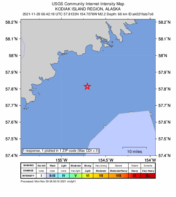
1 person reported to the USGS what they felt; the strongest reported shaking was II, weak shaking.
How well it is located
Reviewed by a seismologist.
- Stations used
- 93
Nearest places
Distance and direction from each place to the epicenter, with its forecast.
Nearby
Within 100 km, magnitude 1.5 and up: 123 in the 60 days after this one and 59 in the 30 days before it.
After
- 2.036 km WSW of Aleneva, Alaska · 1758 days ago · 70 km deep · 73 km away
- 1.833 km W of Karluk, Alaska · 1757 days ago · 68 km deep · 36 km away
- 1.725 km W of Aleneva, Alaska · 1757 days ago · 50 km deep · 85 km away
- 1.635 km NE of Larsen Bay, Alaska · 1756 days ago · 37 km deep · 68 km away
- 1.554 km WNW of Karluk, Alaska · 1754 days ago · 75 km deep · 36 km away
- 1.652 km N of Karluk, Alaska · 1754 days ago · 77 km deep · 29 km away
- 1.671 km WNW of Karluk, Alaska · 1753 days ago · 97 km deep · 46 km away
- 1.624 km W of Aleneva, Alaska · 1753 days ago · 51 km deep · 87 km away
- 1.561 km W of Karluk, Alaska · 1753 days ago · 82 km deep · 55 km away
- 1.637 km N of Old Harbor, Alaska · 1753 days ago · 50 km deep · 92 km away
- 2.051 km WSW of Karluk, Alaska · 1753 days ago · 65 km deep · 59 km away
- 2.081 km WNW of Karluk, Alaska · 1753 days ago · 1 km deep · 65 km away
- 2.153 km W of Karluk, Alaska · 1752 days ago · 81 km deep · 53 km away
- 2.182 km SSE of Igiugig, Alaska · 1752 days ago · 129 km deep · 99 km away
- 2.147 km WNW of Akhiok, Alaska · 1752 days ago · 47 km deep · 75 km away
- 2.1Alaska Peninsula · 1751 days ago · 81 km deep · 74 km away
- 2.416 km NNE of Karluk, Alaska · 1751 days ago · 42 km deep · 28 km away
- 2.074 km WSW of Karluk, Alaska · 1751 days ago · 63 km deep · 80 km away
- 1.681 km WSW of Karluk, Alaska · 1749 days ago · 73 km deep · 80 km away
- 2.060 km WNW of Karluk, Alaska · 1749 days ago · 77 km deep · 44 km away
- 1.894 km WNW of Aleneva, Alaska · 1749 days ago · 88 km deep · 79 km away
- 1.663 km NW of Aleneva, Alaska · 1748 days ago · 7 km deep · 96 km away
- 1.518 km NNW of Karluk, Alaska · 1748 days ago · 58 km deep · 16 km away
- 1.632 km NNE of Larsen Bay, Alaska · 1748 days ago · 47 km deep · 59 km away
- 1.890 km WNW of Karluk, Alaska · 1748 days ago · 3 km deep · 66 km away
- 2.052 km NNW of Karluk, Alaska · 1747 days ago · 84 km deep · 19 km away
- 1.858 km WNW of Karluk, Alaska · 1747 days ago · 89 km deep · 38 km away
- 1.869 km WNW of Aleneva, Alaska · 1746 days ago · 69 km deep · 64 km away
- 2.256 km N of Karluk, Alaska · 1746 days ago · 10 km deep · 32 km away
- 1.658 km N of Karluk, Alaska · 1746 days ago · 4 km deep · 35 km away
- 1.863 km NW of Aleneva, Alaska · 1746 days ago · 70 km deep · 85 km away
- 2.154 km SE of King Salmon, Alaska · 1745 days ago · 148 km deep · 96 km away
- 2.758 km NNW of Karluk, Alaska · 1745 days ago · 89 km deep · 25 km away
- 1.772 km ESE of Egegik, Alaska · 1744 days ago · 127 km deep · 95 km away
- 1.935 km W of Karluk, Alaska · 1744 days ago · 59 km deep · 36 km away
- 1.771 km WNW of Aleneva, Alaska · 1743 days ago · 78 km deep · 60 km away
- 1.969 km NW of Karluk, Alaska · 1743 days ago · 91 km deep · 37 km away
- 1.933 km WNW of Karluk, Alaska · 1743 days ago · 61 km deep · 21 km away
- 1.881 km SW of Karluk, Alaska · 1743 days ago · 61 km deep · 91 km away
- 1.636 km NNW of Akhiok, Alaska · 1742 days ago · 8 km deep · 68 km away
- 1.676 km NW of Aleneva, Alaska · 1741 days ago · 83 km deep · 82 km away
- 1.630 km SSW of Larsen Bay, Alaska · 1741 days ago · 35 km deep · 64 km away
- 1.575 km ENE of Ugashik, Alaska · 1740 days ago · 117 km deep · 91 km away
- 1.839 km NW of Karluk, Alaska · 1740 days ago · 72 km deep · 17 km away
- 1.690 km ESE of Egegik, Alaska · 1739 days ago · 102 km deep · 75 km away
- 1.882 km SSE of Igiugig, Alaska · 1739 days ago · 135 km deep · 99 km away
- 1.660 km W of Akhiok, Alaska · 1739 days ago · 15 km deep · 99 km away
- 2.241 km WNW of Karluk, Alaska · 1738 days ago · 74 km deep · 21 km away
- 1.686 km W of Karluk, Alaska · 1737 days ago · 78 km deep · 79 km away
- 1.845 km NNE of Larsen Bay, Alaska · 1737 days ago · 66 km deep · 57 km away
- 2.382 km S of Kokhanok, Alaska · 1737 days ago · 126 km deep · 97 km away
- 1.735 km NW of Akhiok, Alaska · 1737 days ago · 0 km deep · 79 km away
- 3.165 km ESE of Egegik, Alaska · 1736 days ago · 136 km deep · 97 km away
- 1.583 km N of Karluk, Alaska · 1736 days ago · 81 km deep · 58 km away
- 1.978 km ESE of Egegik, Alaska · 1735 days ago · 124 km deep · 87 km away
- 1.661 km WNW of Karluk, Alaska · 1735 days ago · 10 km deep · 40 km away
- 1.963 km WSW of Karluk, Alaska · 1735 days ago · 63 km deep · 71 km away
- 2.064 km WSW of Karluk, Alaska · 1734 days ago · 60 km deep · 74 km away
- 1.666 km NW of Aleneva, Alaska · 1733 days ago · 70 km deep · 91 km away
- 1.99 km NNW of Akhiok, Alaska · 1733 days ago · 26 km deep · 95 km away
The first 60 of 123.
Before
- 2.359 km W of Akhiok, Alaska · 1759 days ago · 41 km deep · 91 km away
- 1.721 km N of Karluk, Alaska · 1760 days ago · 65 km deep · 17 km away
- 1.890 km ESE of Ugashik, Alaska · 1761 days ago · 6 km deep · 92 km away
- 1.959 km SE of King Salmon, Alaska · 1761 days ago · 153 km deep · 89 km away
- 1.670 km NNE of Karluk, Alaska · 1762 days ago · 69 km deep · 49 km away
- 1.759 km W of Karluk, Alaska · 1762 days ago · 70 km deep · 55 km away
- 2.065 km W of Karluk, Alaska · 1764 days ago · 86 km deep · 56 km away
- 1.983 km ESE of Egegik, Alaska · 1764 days ago · 128 km deep · 84 km away
- 1.689 km WNW of Aleneva, Alaska · 1764 days ago · 86 km deep · 82 km away
- 1.513 km ENE of Karluk, Alaska · 1765 days ago · 42 km deep · 39 km away
- 2.914 km WNW of Larsen Bay, Alaska · 1765 days ago · 41 km deep · 40 km away
- 4.362 km SE of King Salmon, Alaska · 1766 days ago · 144 km deep · 87 km away
- 1.562 km NNW of Karluk, Alaska · 1766 days ago · 82 km deep · 31 km away
- 1.765 km WSW of Karluk, Alaska · 1767 days ago · 66 km deep · 66 km away
- 2.721 km W of Port Lions, Alaska · 1767 days ago · 58 km deep · 87 km away
- 1.666 km NW of Karluk, Alaska · 1769 days ago · 85 km deep · 33 km away
- 1.788 km NW of Aleneva, Alaska · 1770 days ago · 98 km deep · 100 km away
- 2.031 km NNW of Karluk, Alaska · 1770 days ago · 72 km deep · 7 km away
- 1.886 km NNW of Karluk, Alaska · 1771 days ago · 98 km deep · 54 km away
- 1.687 km ESE of Ugashik, Alaska · 1772 days ago · 18 km deep · 94 km away
Earthquakes todayAlaska earthquakesLive radar here
Sources
From the USGS Earthquake Hazards Program and its partner networks, event ak021fats7o6 (also filed as us7000fxwe). Read Wed, Sep 23, 2026, 5:04 AM UTC.