M4.4 earthquake 147 km S of False Pass, Alaska
A magnitude 4.4 earthquake struck 147 km S of False Pass, Alaska on Tue, Oct 5, 2021, 9:21 PM AKDT (05:21 UTC), 35 km (22 mi) below the surface.
Map
Where this earthquake was located, with the others nearby. Select one for its page.
The earthquake
- Magnitude
- 4.4 (mb), light
- Local time
- UTC
- 2021-10-06 05:21:53 UTC
- Depth
- 35.0 km (21.7 mi), shallow
- Epicenter
- 53.533° N, 163.507° W
- Region
- Alaska
- Strongest shaking
- II, weak shaking
- Tsunami flag
- No
- Status
- Reviewed by a seismologist
Shaking
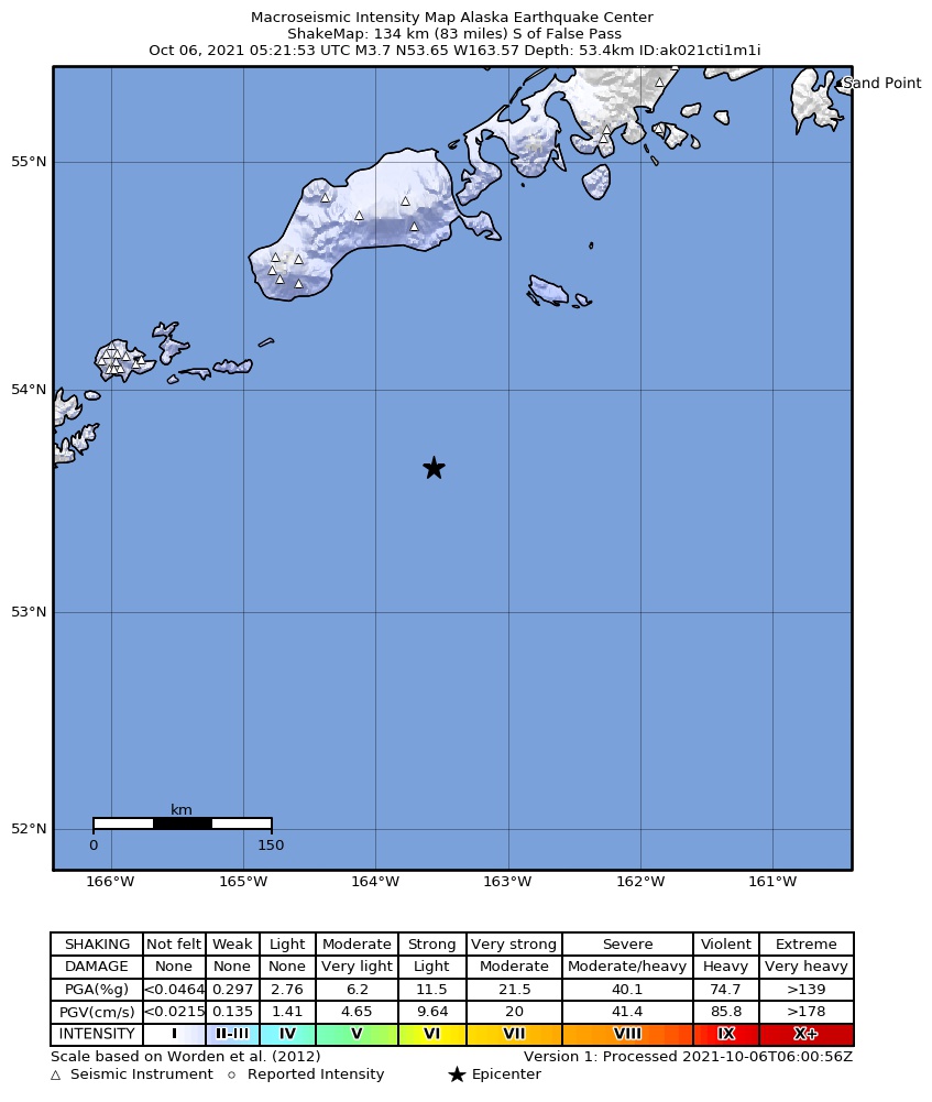
The USGS ShakeMap: shaking estimated from seismic stations and the quake’s size, on the Modified Mercalli intensity scale.
- Strongest estimated
- II, weak shaking
- Peak ground acceleration
- 0.1% of gravity
- Peak ground velocity
- -4.1 cm/s
- Map
- Automatic
Did you feel it?
No one has reported feeling this quake to the USGS.
How well it is located
Reviewed by a seismologist.
- Location uncertainty
- About 5.5 km horizontally, 2.0 km in depth
- Magnitude uncertainty
- ±0.06
- Depth from
- Operator assigned
- Station coverage gap
- 165°
- Stations used
- 81
Nearest places
Distance and direction from each place to the epicenter, with its forecast.
Nearby
Within 100 km, magnitude 1.5 and up: 66 in the 60 days after this one and 78 in the 30 days before it.
After
- 3.3154 km S of False Pass, Alaska · 1813 days ago · 19 km deep · 8 km away
- 4.4153 km S of False Pass, Alaska · 1813 days ago · 10 km deep · 7 km away
- 2.192 km SE of Akutan, Alaska · 1812 days ago · 30 km deep · 81 km away
- 2.467 km SSW of False Pass, Alaska · 1807 days ago · 75 km deep · 94 km away
- 2.184 km SE of Akutan, Alaska · 1806 days ago · 26 km deep · 86 km away
- 3.4132 km SE of Akutan, Alaska · 1805 days ago · 13 km deep · 52 km away
- 2.180 km SE of Akutan, Alaska · 1804 days ago · 39 km deep · 96 km away
- 2.164 km ESE of Akutan, Alaska · 1804 days ago · 76 km deep · 100 km away
- 2.569 km SSW of False Pass, Alaska · 1804 days ago · 61 km deep · 82 km away
- 2.364 km S of False Pass, Alaska · 1801 days ago · 48 km deep · 85 km away
- 3.179 km SSE of False Pass, Alaska · 1801 days ago · 35 km deep · 91 km away
- 2.080 km SE of Akutan, Alaska · 1801 days ago · 58 km deep · 95 km away
- 2.0102 km SSW of False Pass, Alaska · 1798 days ago · 20 km deep · 62 km away
- 3.6102 km SSE of False Pass, Alaska · 1792 days ago · 35 km deep · 56 km away
- 2.899 km SSE of False Pass, Alaska · 1792 days ago · 16 km deep · 60 km away
- 2.5110 km ESE of Akutan, Alaska · 1792 days ago · 35 km deep · 56 km away
- 1.951 km S of False Pass, Alaska · 1791 days ago · 66 km deep · 96 km away
- 2.4160 km S of False Pass, Alaska · 1791 days ago · 25 km deep · 16 km away
- 2.2154 km S of False Pass, Alaska · 1791 days ago · 25 km deep · 10 km away
- 2.8117 km SSE of False Pass, Alaska · 1788 days ago · 26 km deep · 59 km away
- 2.1113 km ESE of Akutan, Alaska · 1788 days ago · 51 km deep · 53 km away
- 2.7114 km ESE of Akutan, Alaska · 1787 days ago · 28 km deep · 52 km away
- 3.9146 km SE of Akutan, Alaska · 1787 days ago · 10 km deep · 52 km away
- 1.994 km E of Akutan, Alaska · 1787 days ago · 78 km deep · 81 km away
- 1.884 km SW of False Pass, Alaska · 1785 days ago · 24 km deep · 93 km away
- 2.1120 km ESE of Akutan, Alaska · 1785 days ago · 49 km deep · 47 km away
- 2.6114 km ESE of Akutan, Alaska · 1784 days ago · 32 km deep · 51 km away
- 2.896 km S of False Pass, Alaska · 1782 days ago · 35 km deep · 51 km away
- 1.995 km E of Akutan, Alaska · 1781 days ago · 26 km deep · 75 km away
- 2.5115 km S of False Pass, Alaska · 1781 days ago · 20 km deep · 36 km away
- 2.182 km S of False Pass, Alaska · 1781 days ago · 42 km deep · 65 km away
- 2.0113 km ESE of Akutan, Alaska · 1780 days ago · 55 km deep · 54 km away
- 1.962 km SSE of False Pass, Alaska · 1780 days ago · 40 km deep · 94 km away
- 2.084 km S of False Pass, Alaska · 1780 days ago · 54 km deep · 64 km away
- 1.978 km SSE of False Pass, Alaska · 1779 days ago · 51 km deep · 76 km away
- 1.991 km S of False Pass, Alaska · 1779 days ago · 26 km deep · 58 km away
- 2.587 km SSE of False Pass, Alaska · 1777 days ago · 12 km deep · 75 km away
- 2.080 km ESE of Akutan, Alaska · 1774 days ago · 68 km deep · 83 km away
- 2.5128 km SE of Akutan, Alaska · 1771 days ago · 10 km deep · 87 km away
- 2.1108 km ESE of Akutan, Alaska · 1770 days ago · 26 km deep · 56 km away
- 2.2105 km ESE of Akutan, Alaska · 1770 days ago · 25 km deep · 58 km away
- 3.8105 km ESE of Akutan, Alaska · 1770 days ago · 41 km deep · 59 km away
- 2.7100 km ESE of Akutan, Alaska · 1770 days ago · 33 km deep · 65 km away
- 2.4138 km SE of Akutan, Alaska · 1769 days ago · 22 km deep · 68 km away
- 2.6112 km ESE of Akutan, Alaska · 1769 days ago · 35 km deep · 51 km away
- 2.073 km SE of Akutan, Alaska · 1769 days ago · 52 km deep · 100 km away
- 3.1Unimak Island region, Alaska · 1769 days ago · 32 km deep · 48 km away
- 3.1112 km ESE of Akutan, Alaska · 1769 days ago · 35 km deep · 51 km away
- 2.3107 km ESE of Akutan, Alaska · 1769 days ago · 48 km deep · 57 km away
- 2.986 km SE of Akutan, Alaska · 1768 days ago · 24 km deep · 98 km away
- 2.7120 km SE of Akutan, Alaska · 1768 days ago · 35 km deep · 79 km away
- 2.6Unimak Island region, Alaska · 1768 days ago · 35 km deep · 59 km away
- 1.9Unimak Island region, Alaska · 1765 days ago · 24 km deep · 54 km away
- 2.172 km SW of False Pass, Alaska · 1764 days ago · 78 km deep · 99 km away
- 1.7102 km SE of Akutan, Alaska · 1761 days ago · 15 km deep · 66 km away
- 1.9139 km SE of Akutan, Alaska · 1761 days ago · 26 km deep · 79 km away
- 1.783 km SE of Akutan, Alaska · 1761 days ago · 50 km deep · 87 km away
- 1.780 km ESE of Akutan, Alaska · 1760 days ago · 48 km deep · 83 km away
- 2.1107 km SSW of False Pass, Alaska · 1757 days ago · 26 km deep · 58 km away
- 3.3135 km SSE of False Pass, Alaska · 1755 days ago · 22 km deep · 53 km away
The first 60 of 66.
Before
- 2.4149 km S of False Pass, Alaska · 1813 days ago · 20 km deep · 3 km away
- 4.5152 km S of False Pass, Alaska · 1813 days ago · 11 km deep · 5 km away
- 4.4129 km S of False Pass, Alaska · 1814 days ago · 22 km deep · 24 km away
- 1.9122 km SSW of False Pass, Alaska · 1814 days ago · 25 km deep · 38 km away
- 2.0119 km ESE of Akutan, Alaska · 1816 days ago · 20 km deep · 46 km away
- 4.0111 km SE of False Pass, Alaska · 1817 days ago · 47 km deep · 91 km away
- 2.075 km ESE of Akutan, Alaska · 1817 days ago · 34 km deep · 88 km away
- 3.0100 km SE of False Pass, Alaska · 1817 days ago · 25 km deep · 92 km away
- 2.9114 km SSE of False Pass, Alaska · 1817 days ago · 21 km deep · 85 km away
- 2.6170 km S of False Pass, Alaska · 1817 days ago · 24 km deep · 26 km away
- 2.151 km S of False Pass, Alaska · 1818 days ago · 63 km deep · 96 km away
- 3.0151 km S of False Pass, Alaska · 1822 days ago · 16 km deep · 4 km away
- 2.096 km SE of Akutan, Alaska · 1823 days ago · 26 km deep · 79 km away
- 2.165 km ESE of Akutan, Alaska · 1823 days ago · 23 km deep · 100 km away
- 2.088 km SE of Akutan, Alaska · 1823 days ago · 61 km deep · 78 km away
- 2.6194 km SSE of False Pass, Alaska · 1823 days ago · 10 km deep · 95 km away
- 2.092 km S of False Pass, Alaska · 1823 days ago · 21 km deep · 55 km away
- 2.9140 km SE of Akutan, Alaska · 1824 days ago · 30 km deep · 53 km away
- 2.393 km S of False Pass, Alaska · 1832 days ago · 26 km deep · 57 km away
- 2.8162 km S of False Pass, Alaska · 1833 days ago · 22 km deep · 16 km away
Earthquakes todayAlaska earthquakesLive radar here
Sources
From the USGS Earthquake Hazards Program and its partner networks, event us6000fs7h (also filed as ak021cti1m1i). Read Wed, Sep 23, 2026, 1:26 PM UTC.