M3.5 earthquake 155 km SSE of Chignik, Alaska
A magnitude 3.5 earthquake struck 155 km SSE of Chignik, Alaska on Sun, Aug 1, 2021, 12:01 PM AKDT (20:01 UTC), 20 km (12 mi) below the surface.
A larger quake followed: M4.1 146 km SE of Perryville, Alaska. This one was a foreshock.
Map
Where this earthquake was located, with the others nearby. Select one for its page.
The earthquake
- Magnitude
- 3.5 (ml), minor
- Local time
- UTC
- 2021-08-01 20:01:15 UTC
- Depth
- 19.7 km (12.2 mi), shallow
- Epicenter
- 55.123° N, 157.059° W
- Region
- Alaska
- Strongest shaking
- I, not felt shaking
- Tsunami flag
- No
- Status
- Reviewed by a seismologist
Shaking
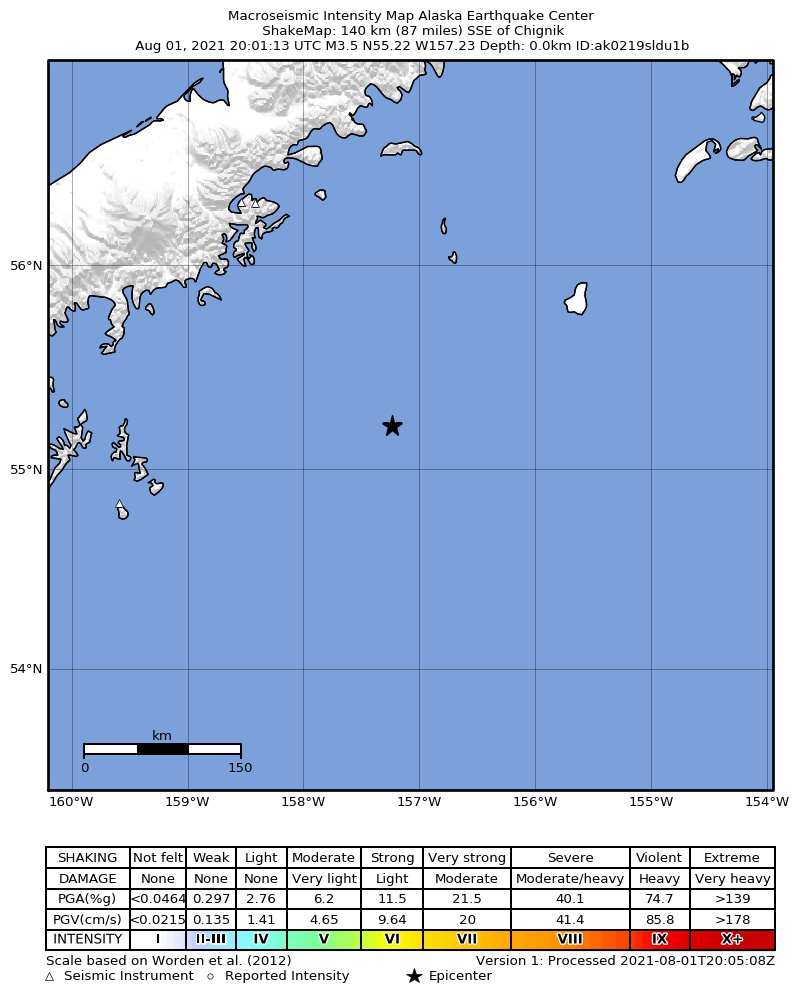
The USGS ShakeMap: shaking estimated from seismic stations and the quake’s size, on the Modified Mercalli intensity scale.
- Strongest estimated
- I, not felt shaking
- Peak ground acceleration
- 0.0% of gravity
- Peak ground velocity
- -5.1 cm/s
- Map
- Automatic
Did you feel it?
No one has reported feeling this quake to the USGS.
How well it is located
Reviewed by a seismologist.
- Stations used
- 63
Nearest places
Distance and direction from each place to the epicenter, with its forecast.
Nearby
Within 100 km, magnitude 1.5 and up: 200 in the 60 days after this one and 0 in the 30 days before it.
After
- 3.3133 km SE of Perryville, Alaska · 1865 days ago · 42 km deep · 31 km away
- 2.2131 km SE of Perryville, Alaska · 1865 days ago · 20 km deep · 31 km away
- 2.9189 km SE of Perryville, Alaska · 1865 days ago · 36 km deep · 39 km away
- 2.3161 km SE of Chignik, Alaska · 1865 days ago · 25 km deep · 8 km away
- 3.1116 km SE of Perryville, Alaska · 1865 days ago · 27 km deep · 57 km away
- 4.1146 km SE of Perryville, Alaska · 1865 days ago · 15 km deep · 36 km away
- 3.2137 km SE of Perryville, Alaska · 1865 days ago · 24 km deep · 30 km away
- 3.3143 km SE of Perryville, Alaska · 1865 days ago · 14 km deep · 33 km away · felt by 1
- 2.8134 km SE of Perryville, Alaska · 1865 days ago · 27 km deep · 31 km away
- 3.4201 km SE of Perryville, Alaska · 1865 days ago · 33 km deep · 50 km away
- 2.6148 km SE of Perryville, Alaska · 1865 days ago · 16 km deep · 24 km away
- 2.5151 km SE of Perryville, Alaska · 1865 days ago · 28 km deep · 51 km away
- 3.0175 km SE of Perryville, Alaska · 1865 days ago · 21 km deep · 29 km away
- 3.3193 km SE of Perryville, Alaska · 1865 days ago · 25 km deep · 44 km away
- 2.2138 km SE of Perryville, Alaska · 1865 days ago · 33 km deep · 38 km away
- 3.1133 km SE of Perryville, Alaska · 1865 days ago · 27 km deep · 30 km away
- 3.9131 km SE of Perryville, Alaska · 1865 days ago · 35 km deep · 29 km away
- 2.5134 km ESE of Chignik, Alaska · 1865 days ago · 16 km deep · 76 km away
- 1.767 km SE of Perryville, Alaska · 1865 days ago · 26 km deep · 95 km away
- 2.8127 km SE of Perryville, Alaska · 1865 days ago · 47 km deep · 47 km away
- 2.6125 km SE of Perryville, Alaska · 1865 days ago · 27 km deep · 43 km away
- 2.6143 km SE of Perryville, Alaska · 1865 days ago · 34 km deep · 36 km away
- 2.1138 km SSE of Chignik, Alaska · 1865 days ago · 25 km deep · 17 km away
- 1.892 km SE of Perryville, Alaska · 1865 days ago · 22 km deep · 67 km away
- 2.3113 km SE of Perryville, Alaska · 1865 days ago · 39 km deep · 52 km away
- 2.3109 km SE of Perryville, Alaska · 1865 days ago · 41 km deep · 49 km away
- 2.5124 km SE of Perryville, Alaska · 1865 days ago · 9 km deep · 34 km away
- 3.0143 km SE of Perryville, Alaska · 1865 days ago · 36 km deep · 36 km away
- 2.5165 km SE of Perryville, Alaska · 1864 days ago · 34 km deep · 28 km away
- 3.0161 km SE of Perryville, Alaska · 1864 days ago · 41 km deep · 25 km away
- 2.4162 km SE of Chignik, Alaska · 1864 days ago · 37 km deep · 9 km away
- 3.0154 km SE of Chignik, Alaska · 1864 days ago · 34 km deep · 21 km away
- 2.6243 km SE of Chignik, Alaska · 1864 days ago · 17 km deep · 89 km away
- 3.4253 km SE of Chignik, Alaska · 1864 days ago · 26 km deep · 99 km away
- 2.0129 km SE of Chignik, Alaska · 1864 days ago · 41 km deep · 64 km away
- 2.4130 km SE of Perryville, Alaska · 1864 days ago · 42 km deep · 58 km away
- 2.5206 km SE of Perryville, Alaska · 1864 days ago · 47 km deep · 58 km away
- 2.0124 km SE of Perryville, Alaska · 1864 days ago · 15 km deep · 48 km away
- 3.4163 km SE of Chignik, Alaska · 1864 days ago · 36 km deep · 55 km away
- 1.767 km SE of Perryville, Alaska · 1864 days ago · 48 km deep · 94 km away
- 2.4194 km SE of Chignik, Alaska · 1864 days ago · 48 km deep · 75 km away
- 2.2125 km SE of Perryville, Alaska · 1864 days ago · 25 km deep · 45 km away
- 2.281 km ESE of Perryville, Alaska · 1864 days ago · 12 km deep · 78 km away
- 2.3177 km SE of Chignik, Alaska · 1864 days ago · 56 km deep · 26 km away
- 2.0138 km SE of Perryville, Alaska · 1864 days ago · 40 km deep · 30 km away
- 2.6190 km SE of Chignik, Alaska · 1863 days ago · 47 km deep · 43 km away
- 1.797 km SE of Chignik, Alaska · 1863 days ago · 7 km deep · 62 km away
- 3.3144 km SSE of Chignik, Alaska · 1863 days ago · 9 km deep · 11 km away
- 4.2128 km SSE of Chignik, Alaska · 1863 days ago · 33 km deep · 29 km away
- 2.7135 km ESE of Chignik, Alaska · 1863 days ago · 49 km deep · 84 km away
- 2.6158 km SE of Perryville, Alaska · 1863 days ago · 43 km deep · 13 km away
- 2.2101 km SSE of Perryville, Alaska · 1863 days ago · 24 km deep · 88 km away
- 2.6182 km SE of Chignik, Alaska · 1863 days ago · 43 km deep · 73 km away
- 2.467 km SE of Perryville, Alaska · 1863 days ago · 25 km deep · 94 km away
- 3.0140 km SE of Perryville, Alaska · 1863 days ago · 26 km deep · 33 km away
- 3.0106 km SE of Perryville, Alaska · 1863 days ago · 12 km deep · 53 km away
- 2.7197 km SE of Chignik, Alaska · 1863 days ago · 5 km deep · 54 km away
- 2.5152 km SE of Perryville, Alaska · 1862 days ago · 23 km deep · 19 km away
- 2.266 km SE of Perryville, Alaska · 1862 days ago · 15 km deep · 95 km away
- 3.7209 km SE of Perryville, Alaska · 1862 days ago · 26 km deep · 60 km away
The first 60 of 200.
Earthquakes todayAlaska earthquakesLive radar here
Sources
From the USGS Earthquake Hazards Program and its partner networks, event ak0219sldu1b (also filed as us6000f1ay). Read Tue, Sep 22, 2026, 11:00 PM UTC.