M4.3 earthquake 116 km NW of Atka, Alaska
A magnitude 4.3 earthquake struck 116 km NW of Atka, Alaska on Mon, Aug 30, 2021, 5:17 PM HADT (02:17 UTC), 255 km (158 mi) below the surface.
A larger quake followed: M4.7 49 km NE of Adak, Alaska. This one was a foreshock.
Map
Where this earthquake was located, with the others nearby. Select one for its page.
The earthquake
- Magnitude
- 4.3 (mb), light
- Local time
- UTC
- 2021-08-31 02:17:11 UTC
- Depth
- 254.5 km (158.2 mi), intermediate-depth
- Epicenter
- 52.857° N, 175.531° W
- Region
- Alaska
- Strongest shaking
- I, not felt shaking
- Tsunami flag
- No
- Status
- Reviewed by a seismologist
Shaking
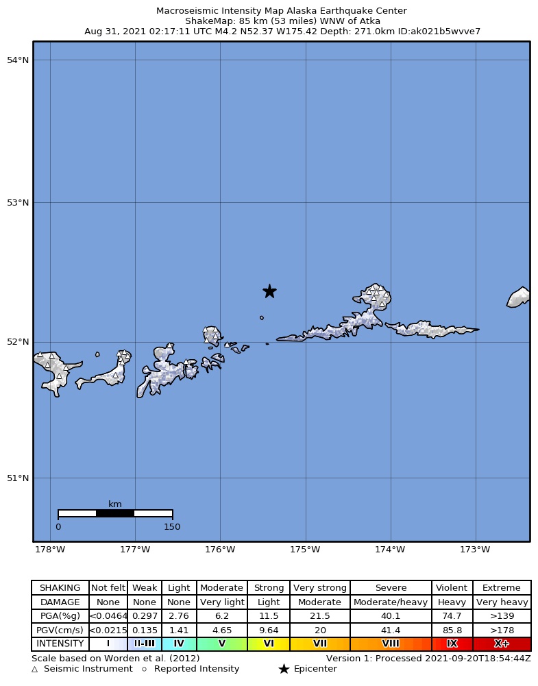
The USGS ShakeMap: shaking estimated from seismic stations and the quake’s size, on the Modified Mercalli intensity scale.
- Strongest estimated
- I, not felt shaking
- Peak ground acceleration
- 0.1% of gravity
- Peak ground velocity
- -3.3 cm/s
- Map
- Automatic
Did you feel it?
No one has reported feeling this quake to the USGS.
How well it is located
Reviewed by a seismologist.
- Location uncertainty
- About 6.4 km horizontally, 4.4 km in depth
- Magnitude uncertainty
- ±0.03
- Depth from
- From location
- Station coverage gap
- 72°
- Stations used
- 112
Nearby
Within 100 km, magnitude 1.5 and up: 25 in the 60 days after this one and 12 in the 30 days before it.
After
- 3.246 km ENE of Adak, Alaska · 1848 days ago · 137 km deep · 95 km away
- 2.958 km E of Adak, Alaska · 1848 days ago · 156 km deep · 100 km away
- 1.652 km ENE of Adak, Alaska · 1848 days ago · 148 km deep · 98 km away
- 1.951 km ENE of Adak, Alaska · 1845 days ago · 163 km deep · 91 km away
- 1.674 km ENE of Adak, Alaska · 1844 days ago · 149 km deep · 88 km away
- 1.561 km W of Atka, Alaska · 1844 days ago · 13 km deep · 87 km away
- 1.774 km ENE of Adak, Alaska · 1843 days ago · 137 km deep · 88 km away
- 1.960 km ENE of Adak, Alaska · 1843 days ago · 150 km deep · 88 km away
- 2.278 km ENE of Adak, Alaska · 1842 days ago · 236 km deep · 83 km away
- 1.739 km NE of Adak, Alaska · 1842 days ago · 132 km deep · 95 km away
- 2.543 km NW of Atka, Alaska · 1832 days ago · 216 km deep · 73 km away
- 2.970 km NE of Adak, Alaska · 1829 days ago · 228 km deep · 63 km away
- 2.182 km ENE of Adak, Alaska · 1829 days ago · 90 km deep · 80 km away
- 1.945 km NE of Adak, Alaska · 1826 days ago · 135 km deep · 89 km away
- 2.0150 km NNW of Atka, Alaska · 1825 days ago · 104 km deep · 71 km away
- 4.749 km NE of Adak, Alaska · 1818 days ago · 129 km deep · 84 km away
- 1.657 km ENE of Adak, Alaska · 1818 days ago · 86 km deep · 97 km away
- 1.841 km NE of Adak, Alaska · 1815 days ago · 3 km deep · 95 km away
- 3.884 km NE of Adak, Alaska · 1810 days ago · 182 km deep · 52 km away
- 1.959 km WNW of Atka, Alaska · 1805 days ago · 108 km deep · 60 km away
- 4.1147 km NNE of Adak, Alaska · 1800 days ago · 10 km deep · 46 km away
- 2.469 km WNW of Atka, Alaska · 1797 days ago · 120 km deep · 58 km away
- 2.081 km ENE of Adak, Alaska · 1796 days ago · 115 km deep · 90 km away
- 2.974 km W of Atka, Alaska · 1793 days ago · 252 km deep · 85 km away
- 3.747 km NE of Adak, Alaska · 1792 days ago · 188 km deep · 89 km away
Before
- 1.772 km WSW of Atka, Alaska · 1851 days ago · 122 km deep · 92 km away
- 1.578 km W of Atka, Alaska · 1852 days ago · 110 km deep · 86 km away
- 1.942 km NE of Adak, Alaska · 1852 days ago · 189 km deep · 91 km away
- 1.773 km WSW of Atka, Alaska · 1854 days ago · 73 km deep · 99 km away
- 2.8Andreanof Islands, Aleutian Islands, Alaska · 1856 days ago · 219 km deep · 84 km away
- 1.657 km ENE of Adak, Alaska · 1857 days ago · 175 km deep · 86 km away
- 1.664 km ENE of Adak, Alaska · 1859 days ago · 12 km deep · 88 km away
- 3.349 km N of Atka, Alaska · 1859 days ago · 247 km deep · 98 km away
- 1.863 km W of Atka, Alaska · 1861 days ago · 170 km deep · 76 km away
- 2.053 km ENE of Adak, Alaska · 1862 days ago · 146 km deep · 93 km away
- 1.741 km ENE of Adak, Alaska · 1868 days ago · 6 km deep · 97 km away
- 1.977 km NE of Adak, Alaska · 1875 days ago · 138 km deep · 56 km away
Earthquakes todayAlaska earthquakesLive radar here
Sources
From the USGS Earthquake Hazards Program and its partner networks, event us7000f605 (also filed as ak021b5wvve7). Read Thu, Sep 24, 2026, 5:01 AM UTC.