M3.9 earthquake 48 km E of Atka, Alaska
A magnitude 3.9 earthquake struck 48 km E of Atka, Alaska on Fri, Aug 13, 2021, 8:32 AM HADT (17:32 UTC), 105 km (65 mi) below the surface.
A larger quake followed: M4.7 67 km ESE of Atka, Alaska. This one was a foreshock.
Map
Where this earthquake was located, with the others nearby. Select one for its page.
The earthquake
- Magnitude
- 3.9 (mb), minor
- Local time
- UTC
- 2021-08-13 17:32:15 UTC
- Depth
- 105.0 km (65.2 mi), intermediate-depth
- Epicenter
- 52.154° N, 173.494° W
- Region
- Alaska
- Strongest shaking
- III, weak shaking
- Tsunami flag
- No
- Status
- Reviewed by a seismologist
Shaking
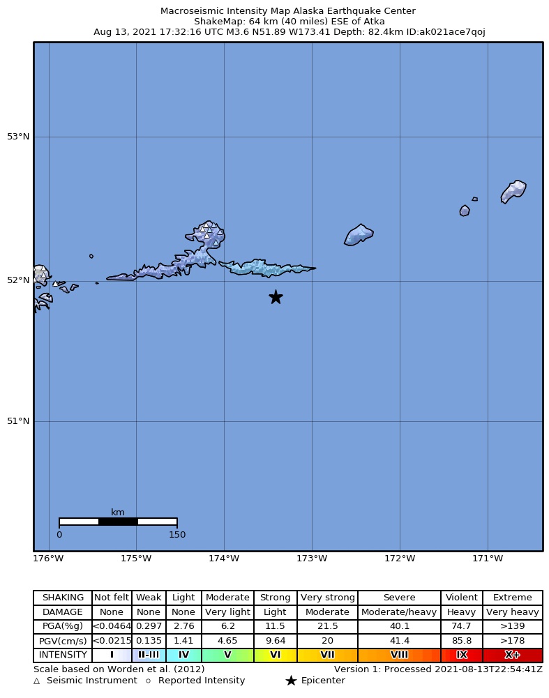
The USGS ShakeMap: shaking estimated from seismic stations and the quake’s size, on the Modified Mercalli intensity scale.
- Strongest estimated
- III, weak shaking
- Peak ground acceleration
- 0.3% of gravity
- Peak ground velocity
- -2.5 cm/s
- Map
- Automatic
Did you feel it?
No one has reported feeling this quake to the USGS.
How well it is located
Reviewed by a seismologist.
- Location uncertainty
- About 8.6 km horizontally, 5.2 km in depth
- Magnitude uncertainty
- ±0.09
- Depth from
- From location
- Station coverage gap
- 155°
- Stations used
- 104
Nearby
Within 100 km, magnitude 1.5 and up: 70 in the 60 days after this one and 58 in the 30 days before it.
After
- 2.753 km E of Atka, Alaska · 1867 days ago · 10 km deep · 12 km away
- 1.966 km E of Atka, Alaska · 1866 days ago · 129 km deep · 24 km away
- 3.038 km SSE of Atka, Alaska · 1864 days ago · 67 km deep · 39 km away
- 2.678 km ESE of Atka, Alaska · 1863 days ago · 44 km deep · 35 km away
- 3.227 km E of Atka, Alaska · 1861 days ago · 19 km deep · 23 km away
- 2.829 km NNE of Atka, Alaska · 1861 days ago · 217 km deep · 51 km away
- 1.748 km E of Atka, Alaska · 1861 days ago · 16 km deep · 9 km away
- 4.767 km ESE of Atka, Alaska · 1861 days ago · 79 km deep · 24 km away
- 2.163 km ESE of Atka, Alaska · 1861 days ago · 74 km deep · 20 km away
- 1.833 km E of Atka, Alaska · 1860 days ago · 13 km deep · 18 km away
- 2.5102 km SSE of Atka, Alaska · 1860 days ago · 10 km deep · 93 km away
- 1.742 km SW of Atka, Alaska · 1860 days ago · 53 km deep · 81 km away
- 2.9111 km E of Atka, Alaska · 1860 days ago · 25 km deep · 63 km away
- 2.853 km SSE of Atka, Alaska · 1860 days ago · 35 km deep · 52 km away
- 2.6130 km ESE of Atka, Alaska · 1860 days ago · 35 km deep · 82 km away
- 1.967 km ESE of Atka, Alaska · 1860 days ago · 60 km deep · 30 km away
- 2.059 km SSE of Atka, Alaska · 1859 days ago · 15 km deep · 53 km away
- 3.349 km N of Atka, Alaska · 1859 days ago · 247 km deep · 69 km away
- 1.921 km SW of Atka, Alaska · 1859 days ago · 9 km deep · 64 km away
- 2.318 km N of Atka, Alaska · 1859 days ago · 146 km deep · 51 km away
- 1.934 km SSW of Atka, Alaska · 1858 days ago · 71 km deep · 71 km away
- 1.739 km ESE of Atka, Alaska · 1857 days ago · 23 km deep · 16 km away
- 1.690 km SSE of Atka, Alaska · 1857 days ago · 41 km deep · 83 km away
- 1.529 km ESE of Atka, Alaska · 1857 days ago · 36 km deep · 21 km away
- 1.74 km NNE of Atka, Alaska · 1857 days ago · 129 km deep · 47 km away
- 2.8Andreanof Islands, Aleutian Islands, Alaska · 1856 days ago · 219 km deep · 85 km away
- 1.542 km ESE of Atka, Alaska · 1855 days ago · 14 km deep · 21 km away
- 2.983 km SE of Atka, Alaska · 1854 days ago · 35 km deep · 47 km away
- 2.085 km SSE of Atka, Alaska · 1854 days ago · 4 km deep · 71 km away
- 1.661 km SSE of Atka, Alaska · 1853 days ago · 25 km deep · 59 km away
- 1.877 km ESE of Atka, Alaska · 1852 days ago · 34 km deep · 37 km away
- 1.647 km ESE of Atka, Alaska · 1850 days ago · 11 km deep · 11 km away
- 1.836 km NE of Atka, Alaska · 1850 days ago · 119 km deep · 41 km away
- 1.753 km SSE of Atka, Alaska · 1847 days ago · 35 km deep · 48 km away
- 2.936 km ENE of Atka, Alaska · 1847 days ago · 179 km deep · 27 km away
- 2.018 km W of Atka, Alaska · 1847 days ago · 170 km deep · 67 km away
- 2.7107 km ESE of Atka, Alaska · 1846 days ago · 35 km deep · 61 km away
- 2.5109 km ESE of Atka, Alaska · 1846 days ago · 33 km deep · 64 km away
- 3.1113 km SE of Atka, Alaska · 1846 days ago · 35 km deep · 78 km away
- 2.811 km NNE of Atka, Alaska · 1845 days ago · 10 km deep · 45 km away
- 2.866 km S of Atka, Alaska · 1844 days ago · 35 km deep · 84 km away
- 2.5112 km ESE of Atka, Alaska · 1843 days ago · 35 km deep · 66 km away
- 2.114 km NW of Atka, Alaska · 1842 days ago · 155 km deep · 60 km away
- 1.935 km NE of Atka, Alaska · 1842 days ago · 145 km deep · 35 km away
- 2.893 km SSE of Atka, Alaska · 1842 days ago · 35 km deep · 88 km away
- 1.554 km ENE of Atka, Alaska · 1842 days ago · 4 km deep · 33 km away
- 3.0140 km E of Atka, Alaska · 1842 days ago · 59 km deep · 92 km away
- 3.147 km S of Atka, Alaska · 1839 days ago · 27 km deep · 68 km away
- 3.131 km S of Atka, Alaska · 1839 days ago · 4 km deep · 60 km away
- 1.950 km SSW of Atka, Alaska · 1839 days ago · 61 km deep · 76 km away
- 2.9122 km SE of Atka, Alaska · 1837 days ago · 30 km deep · 84 km away
- 3.1110 km SE of Atka, Alaska · 1837 days ago · 35 km deep · 80 km away
- 2.687 km S of Atka, Alaska · 1833 days ago · 35 km deep · 95 km away
- 1.947 km SSW of Atka, Alaska · 1833 days ago · 53 km deep · 73 km away
- 2.543 km NW of Atka, Alaska · 1832 days ago · 216 km deep · 87 km away
- 2.7105 km SSE of Atka, Alaska · 1830 days ago · 35 km deep · 85 km away
- 2.796 km SSE of Atka, Alaska · 1830 days ago · 35 km deep · 91 km away
- 2.332 km ESE of Atka, Alaska · 1829 days ago · 126 km deep · 18 km away
- 2.777 km SE of Atka, Alaska · 1829 days ago · 35 km deep · 44 km away
- 3.464 km SSE of Atka, Alaska · 1829 days ago · 35 km deep · 64 km away
The first 60 of 70.
Before
- 3.3110 km ESE of Atka, Alaska · 1868 days ago · 208 km deep · 63 km away
- 1.653 km SSW of Atka, Alaska · 1868 days ago · 15 km deep · 79 km away
- 2.746 km S of Atka, Alaska · 1868 days ago · 35 km deep · 57 km away
- 3.028 km WSW of Atka, Alaska · 1868 days ago · 71 km deep · 75 km away
- 2.890 km SE of Atka, Alaska · 1869 days ago · 35 km deep · 54 km away
- 2.015 km N of Atka, Alaska · 1869 days ago · 4 km deep · 51 km away
- 1.613 km N of Atka, Alaska · 1869 days ago · 5 km deep · 52 km away
- 2.315 km N of Atka, Alaska · 1870 days ago · 4 km deep · 51 km away
- 2.114 km N of Atka, Alaska · 1870 days ago · 4 km deep · 52 km away
- 1.513 km N of Atka, Alaska · 1870 days ago · 5 km deep · 52 km away
- 2.014 km N of Atka, Alaska · 1870 days ago · 5 km deep · 51 km away
- 2.114 km N of Atka, Alaska · 1870 days ago · 5 km deep · 52 km away
- 1.815 km N of Atka, Alaska · 1870 days ago · 3 km deep · 51 km away
- 1.813 km N of Atka, Alaska · 1870 days ago · 4 km deep · 52 km away
- 2.068 km SE of Atka, Alaska · 1870 days ago · 23 km deep · 51 km away
- 3.160 km SSW of Atka, Alaska · 1870 days ago · 224 km deep · 90 km away
- 3.3Andreanof Islands, Aleutian Islands, Alaska · 1870 days ago · 35 km deep · 69 km away
- 2.122 km SSW of Atka, Alaska · 1871 days ago · 152 km deep · 61 km away
- 1.930 km SSW of Atka, Alaska · 1872 days ago · 65 km deep · 69 km away
- 2.766 km S of Atka, Alaska · 1874 days ago · 35 km deep · 78 km away
Earthquakes todayAlaska earthquakesLive radar here
Sources
From the USGS Earthquake Hazards Program and its partner networks, event us6000f5rq (also filed as ak021ace7qoj). Read Thu, Sep 24, 2026, 3:07 AM UTC.