M4.2 earthquake 89 km ESE of Akutan, Alaska
A magnitude 4.2 earthquake struck 89 km ESE of Akutan, Alaska on Thu, Jul 15, 2021, 5:37 AM AKDT (13:37 UTC), 10 km (6 mi) below the surface.
A larger quake followed: M4.5 147 km S of False Pass, Alaska. This one was a foreshock.
Map
Where this earthquake was located, with the others nearby. Select one for its page.
The earthquake
- Magnitude
- 4.2 (mb), light
- Local time
- UTC
- 2021-07-15 13:37:34 UTC
- Depth
- 10.3 km (6.4 mi), shallow
- Epicenter
- 53.948° N, 164.455° W
- Region
- Alaska
- Strongest shaking
- III, weak shaking
- Tsunami flag
- No
- Status
- Reviewed by a seismologist
Shaking
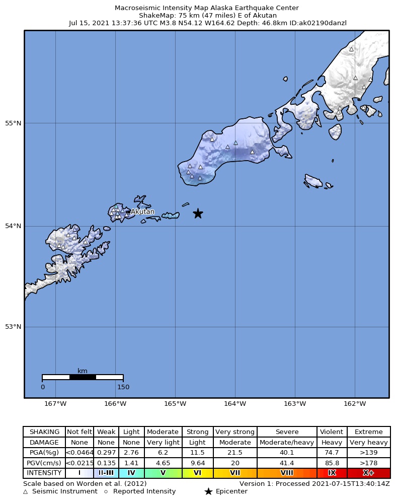
The USGS ShakeMap: shaking estimated from seismic stations and the quake’s size, on the Modified Mercalli intensity scale.
- Strongest estimated
- III, weak shaking
- Peak ground acceleration
- 0.4% of gravity
- Peak ground velocity
- -2.0 cm/s
- Map
- Automatic
Did you feel it?
No one has reported feeling this quake to the USGS.
How well it is located
Reviewed by a seismologist.
- Location uncertainty
- About 2.7 km horizontally, 5.0 km in depth
- Magnitude uncertainty
- ±0.08
- Depth from
- From location
- Station coverage gap
- 136°
- Stations used
- 67
Nearest places
Distance and direction from each place to the epicenter, with its forecast.
Nearby
Within 100 km, magnitude 1.5 and up: 169 in the 60 days after this one and 30 in the 30 days before it.
After
- 1.5140 km SE of Akutan, Alaska · 1896 days ago · 39 km deep · 75 km away
- 1.880 km E of Akutan, Alaska · 1896 days ago · 26 km deep · 16 km away
- 1.6167 km S of False Pass, Alaska · 1895 days ago · 25 km deep · 91 km away
- 2.0152 km S of False Pass, Alaska · 1894 days ago · 54 km deep · 75 km away
- 1.794 km SW of False Pass, Alaska · 1894 days ago · 61 km deep · 28 km away
- 2.2144 km S of False Pass, Alaska · 1894 days ago · 63 km deep · 66 km away
- 1.791 km SSE of Akutan, Alaska · 1893 days ago · 26 km deep · 81 km away
- 2.037 km SSW of False Pass, Alaska · 1893 days ago · 95 km deep · 85 km away
- 1.777 km SE of Akutan, Alaska · 1893 days ago · 52 km deep · 38 km away
- 2.073 km SE of Akutan, Alaska · 1893 days ago · 57 km deep · 37 km away
- 2.16 km SE of Akutan, Alaska · 1893 days ago · 114 km deep · 83 km away
- 2.422 km ESE of Akutan, Alaska · 1893 days ago · 120 km deep · 67 km away
- 1.594 km E of Akutan, Alaska · 1892 days ago · 21 km deep · 19 km away
- 2.087 km SE of Akutan, Alaska · 1892 days ago · 37 km deep · 45 km away
- 1.658 km SE of Unalaska, Alaska · 1891 days ago · 78 km deep · 100 km away
- 2.1104 km SE of Akutan, Alaska · 1889 days ago · 51 km deep · 43 km away
- 2.094 km SSE of Akutan, Alaska · 1889 days ago · 65 km deep · 71 km away
- 1.678 km E of Akutan, Alaska · 1888 days ago · 20 km deep · 31 km away
- 1.743 km SE of Akutan, Alaska · 1888 days ago · 63 km deep · 60 km away
- 1.8111 km S of False Pass, Alaska · 1887 days ago · 41 km deep · 88 km away
- 2.294 km SSW of False Pass, Alaska · 1887 days ago · 68 km deep · 27 km away
- 2.5100 km S of False Pass, Alaska · 1887 days ago · 20 km deep · 85 km away
- 1.562 km ESE of Akutan, Alaska · 1887 days ago · 57 km deep · 29 km away
- 1.754 km SSW of False Pass, Alaska · 1887 days ago · 78 km deep · 67 km away
- 1.946 km S of Akutan, Alaska · 1886 days ago · 54 km deep · 90 km away
- 1.578 km E of Akutan, Alaska · 1885 days ago · 13 km deep · 28 km away
- 1.577 km E of Akutan, Alaska · 1885 days ago · 13 km deep · 29 km away
- 2.277 km SSE of Akutan, Alaska · 1884 days ago · 26 km deep · 81 km away
- 3.4109 km ESE of Akutan, Alaska · 1884 days ago · 22 km deep · 33 km away
- 1.878 km E of Akutan, Alaska · 1884 days ago · 13 km deep · 28 km away
- 1.876 km E of Akutan, Alaska · 1883 days ago · 13 km deep · 29 km away
- 1.870 km SSE of Akutan, Alaska · 1882 days ago · 48 km deep · 73 km away
- 1.996 km ESE of Akutan, Alaska · 1882 days ago · 42 km deep · 13 km away
- 1.576 km E of Akutan, Alaska · 1881 days ago · 21 km deep · 31 km away
- 2.0118 km S of False Pass, Alaska · 1881 days ago · 41 km deep · 67 km away
- 1.7102 km SE of Akutan, Alaska · 1880 days ago · 26 km deep · 42 km away
- 1.775 km E of Akutan, Alaska · 1880 days ago · 23 km deep · 35 km away
- 3.219 km E of Akutan, Alaska · 1879 days ago · 83 km deep · 69 km away
- 1.738 km SSE of Akutan, Alaska · 1876 days ago · 62 km deep · 76 km away
- 1.9100 km SSE of Akutan, Alaska · 1876 days ago · 25 km deep · 83 km away
- 1.9113 km ESE of Akutan, Alaska · 1876 days ago · 26 km deep · 33 km away
- 1.8110 km S of False Pass, Alaska · 1876 days ago · 19 km deep · 51 km away
- 1.695 km SSE of Akutan, Alaska · 1875 days ago · 23 km deep · 78 km away
- 2.176 km E of Akutan, Alaska · 1873 days ago · 14 km deep · 31 km away
- 1.986 km SE of Akutan, Alaska · 1873 days ago · 47 km deep · 55 km away
- 2.596 km SE of Akutan, Alaska · 1872 days ago · 35 km deep · 59 km away
- 3.2110 km ESE of Akutan, Alaska · 1872 days ago · 20 km deep · 22 km away
- 1.642 km SE of Akutan, Alaska · 1872 days ago · 53 km deep · 55 km away
- 2.191 km S of False Pass, Alaska · 1872 days ago · 26 km deep · 57 km away
- 2.9116 km ESE of Akutan, Alaska · 1871 days ago · 27 km deep · 30 km away
- 2.3118 km ESE of Akutan, Alaska · 1871 days ago · 23 km deep · 33 km away
- 2.6104 km S of False Pass, Alaska · 1871 days ago · 35 km deep · 87 km away
- 2.542 km SSE of False Pass, Alaska · 1871 days ago · 10 km deep · 99 km away
- 1.874 km SE of Akutan, Alaska · 1871 days ago · 26 km deep · 57 km away
- 2.1148 km SE of Akutan, Alaska · 1870 days ago · 33 km deep · 83 km away
- 1.897 km SSW of False Pass, Alaska · 1870 days ago · 24 km deep · 25 km away
- 1.6100 km SSE of Akutan, Alaska · 1870 days ago · 15 km deep · 89 km away
- 1.682 km ENE of Akutan, Alaska · 1870 days ago · 20 km deep · 40 km away
- 1.9112 km S of False Pass, Alaska · 1869 days ago · 26 km deep · 79 km away
- 2.153 km WSW of False Pass, Alaska · 1869 days ago · 4 km deep · 90 km away
The first 60 of 169.
Before
- 1.799 km SE of Akutan, Alaska · 1897 days ago · 26 km deep · 46 km away
- 2.991 km SE of Akutan, Alaska · 1897 days ago · 47 km deep · 41 km away
- 1.678 km S of Akutan, Alaska · 1897 days ago · 20 km deep · 93 km away
- 1.8109 km S of False Pass, Alaska · 1897 days ago · 41 km deep · 81 km away
- 1.9123 km S of False Pass, Alaska · 1898 days ago · 28 km deep · 67 km away
- 2.5156 km S of False Pass, Alaska · 1898 days ago · 32 km deep · 82 km away
- 3.541 km SSW of False Pass, Alaska · 1899 days ago · 86 km deep · 83 km away
- 1.940 km S of False Pass, Alaska · 1900 days ago · 10 km deep · 91 km away
- 2.5103 km ESE of Akutan, Alaska · 1901 days ago · 26 km deep · 14 km away
- 1.969 km SSE of Akutan, Alaska · 1901 days ago · 54 km deep · 69 km away
- 2.093 km SSE of False Pass, Alaska · 1901 days ago · 19 km deep · 91 km away
- 1.638 km SSE of Akutan, Alaska · 1901 days ago · 90 km deep · 73 km away
- 1.864 km ESE of Akutan, Alaska · 1901 days ago · 22 km deep · 24 km away
- 2.1103 km S of False Pass, Alaska · 1901 days ago · 20 km deep · 56 km away
- 1.6104 km ESE of Akutan, Alaska · 1902 days ago · 22 km deep · 16 km away
- 2.057 km NE of Akutan, Alaska · 1904 days ago · 108 km deep · 80 km away
- 2.4162 km S of False Pass, Alaska · 1905 days ago · 29 km deep · 86 km away
- 2.414 km S of Akutan, Alaska · 1905 days ago · 103 km deep · 88 km away
- 2.077 km S of False Pass, Alaska · 1906 days ago · 66 km deep · 70 km away
- 3.8141 km S of False Pass, Alaska · 1906 days ago · 17 km deep · 67 km away
Earthquakes todayAlaska earthquakesLive radar here
Sources
From the USGS Earthquake Hazards Program and its partner networks, event us7000em68 (also filed as ak02190danzl). Read Thu, Sep 24, 2026, 12:15 AM UTC.