M3.4 earthquake 9 km NW of Perry, Oklahoma
A magnitude 3.4 earthquake struck 9 km NW of Perry, Oklahoma on Mon, Aug 3, 2020, 6:13 PM CDT (23:13 UTC), 8 km (5 mi) below the surface.
A larger quake followed: M3.5 3 km SE of Meno, Oklahoma. This one was a foreshock.
Map
Where this earthquake was located, with the others nearby. Select one for its page.
The earthquake
- Magnitude
- 3.4 (ml), minor
- Local time
- UTC
- 2020-08-03 23:13:45 UTC
- Depth
- 7.6 km (4.7 mi), shallow
- Epicenter
- 36.358° N, 97.360° W
- Region
- Oklahoma
- Felt reports
- 10
- Tsunami flag
- No
- Status
- Reviewed by a seismologist
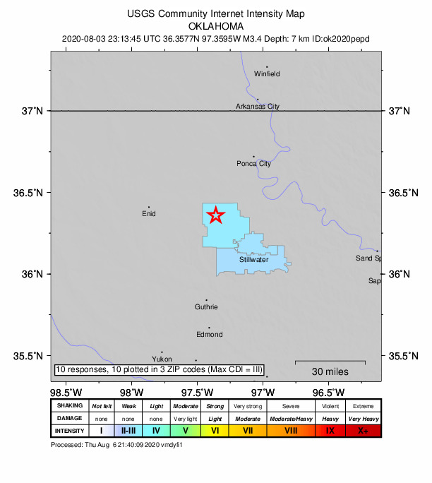
Did you feel it?
10 people reported to the USGS what they felt; the strongest reported shaking was III, weak shaking.
Fault motion and ground failure
How the rock slipped, from the moment tensor, and the USGS estimate of landslides and liquefaction.
- Faulting
- Strike-slip
- Moment magnitude
- 3.2 Mwr
- Nodal plane 1
- Strike 305°, dip 75°, rake -25°
- Nodal plane 2
- Strike 42°, dip 66°, rake -164°
How well it is located
Reviewed by a seismologist.
- Magnitude uncertainty
- ±0.23
- Station coverage gap
- 35°
- Stations used
- 100
Nearest places
Distance and direction from each place to the epicenter, with its forecast.
Nearby
Within 100 km, magnitude 1.5 and up: 141 in the 60 days after this one and 54 in the 30 days before it.
After
- 2.59 km NW of Perry, Oklahoma · 2241 days ago · 8 km deep · 1 km away
- 1.92 km SSE of Ames, Oklahoma · 2241 days ago · 9 km deep · 75 km away
- 1.53 km SE of Meno, Oklahoma · 2241 days ago · 7 km deep · 71 km away
- 1.52 km S of Ames, Oklahoma · 2240 days ago · 6 km deep · 75 km away
- 1.62 km NNW of Hunter, Oklahoma · 2240 days ago · 6 km deep · 37 km away
- 1.86 km NNE of Loyal, Oklahoma · 2240 days ago · 5 km deep · 76 km away
- 3.05 km N of Ames, Oklahoma · 2240 days ago · 8 km deep · 73 km away · felt by 3
- 2.49 km NW of Perry, Oklahoma · 2240 days ago · 8 km deep · 1 km away
- 1.75 km NNE of Ames, Oklahoma · 2240 days ago · 7 km deep · 73 km away
- 1.53 km SE of Meno, Oklahoma · 2239 days ago · 6 km deep · 71 km away
- 1.55 km NNE of Ames, Oklahoma · 2239 days ago · 8 km deep · 73 km away
- 2.37 km N of Spencer, Oklahoma · 2239 days ago · 6 km deep · 85 km away
- 1.610 km NW of Perry, Oklahoma · 2239 days ago · 8 km deep · 1 km away
- 1.67 km W of Jet, Oklahoma · 2237 days ago · 4 km deep · 88 km away
- 1.68 km ENE of Nescatunga, Oklahoma · 2237 days ago · 8 km deep · 80 km away
- 1.69 km ESE of Ames, Oklahoma · 2237 days ago · 8 km deep · 67 km away
- 1.511 km NE of Harrah, Oklahoma · 2236 days ago · 7 km deep · 91 km away
- 1.86 km N of Nardin, Oklahoma · 2235 days ago · 5 km deep · 57 km away
- 1.67 km NNE of Nardin, Oklahoma · 2235 days ago · 8 km deep · 57 km away
- 1.69 km WSW of Ringwood, Oklahoma · 2233 days ago · 7 km deep · 88 km away
- 1.54 km NNE of Okeene, Oklahoma · 2232 days ago · 7 km deep · 87 km away
- 2.03 km W of Marshall, Oklahoma · 2231 days ago · 5 km deep · 36 km away
- 3.29 km NW of Perry, Oklahoma · 2231 days ago · 7 km deep · 1 km away · felt by 5
- 2.24 km W of Marshall, Oklahoma · 2231 days ago · 6 km deep · 36 km away
- 2.010 km W of Lamont, Oklahoma · 2231 days ago · 5 km deep · 47 km away
- 1.98 km NNW of Coyle, Oklahoma · 2230 days ago · 7 km deep · 38 km away
- 1.53 km ENE of Hennessey, Oklahoma · 2230 days ago · 6 km deep · 52 km away
- 1.78 km NNW of Coyle, Oklahoma · 2230 days ago · 7 km deep · 37 km away
- 1.98 km N of Coyle, Oklahoma · 2230 days ago · 7 km deep · 38 km away
- 1.95 km SW of Kingfisher, Oklahoma · 2230 days ago · 8 km deep · 81 km away
- 1.89 km NW of Perry, Oklahoma · 2230 days ago · 7 km deep · 0 km away
- 2.13 km ENE of Hennessey, Oklahoma · 2229 days ago · 5 km deep · 52 km away
- 3.13 km W of Marshall, Oklahoma · 2229 days ago · 5 km deep · 36 km away · felt by 1
- 2.74 km W of Marshall, Oklahoma · 2229 days ago · 6 km deep · 36 km away
- 1.58 km N of Coyle, Oklahoma · 2229 days ago · 6 km deep · 38 km away
- 1.810 km NW of Pawnee, Oklahoma · 2229 days ago · 7 km deep · 44 km away
- 2.24 km W of Marshall, Oklahoma · 2229 days ago · 6 km deep · 36 km away
- 1.64 km W of Marshall, Oklahoma · 2229 days ago · 5 km deep · 36 km away
- 1.69 km NW of Perry, Oklahoma · 2229 days ago · 7 km deep · 0 km away
- 1.83 km W of Marshall, Oklahoma · 2229 days ago · 5 km deep · 36 km away · felt by 1
- 1.85 km SE of Fairview, Oklahoma · 2229 days ago · 7 km deep · 98 km away
- 1.63 km ENE of Hennessey, Oklahoma · 2229 days ago · 5 km deep · 52 km away
- 1.69 km NW of Perry, Oklahoma · 2229 days ago · 7 km deep · 1 km away
- 2.14 km SE of Fairview, Oklahoma · 2228 days ago · 7 km deep · 98 km away
- 1.63 km E of Red Rock, Oklahoma · 2227 days ago · 7 km deep · 23 km away
- 1.63 km ENE of Hennessey, Oklahoma · 2227 days ago · 6 km deep · 52 km away
- 1.99 km NW of Perry, Oklahoma · 2226 days ago · 7 km deep · 1 km away
- 1.510 km W of Lamont, Oklahoma · 2226 days ago · 5 km deep · 47 km away
- 1.79 km NW of Perry, Oklahoma · 2224 days ago · 8 km deep · 1 km away
- 1.98 km NNW of Coyle, Oklahoma · 2224 days ago · 7 km deep · 38 km away
- 1.97 km ENE of Orlando, Oklahoma · 2223 days ago · 17 km deep · 22 km away
- 1.85 km NNE of Edmond, Oklahoma · 2223 days ago · 7 km deep · 74 km away
- 1.66 km SE of Cushing, Oklahoma · 2222 days ago · 7 km deep · 74 km away
- 2.09 km NW of Perry, Oklahoma · 2222 days ago · 7 km deep · 0 km away
- 1.79 km NW of Perry, Oklahoma · 2222 days ago · 6 km deep · 1 km away
- 2.16 km NW of Ames, Oklahoma · 2222 days ago · 7 km deep · 79 km away
- 2.35 km NW of Ames, Oklahoma · 2221 days ago · 8 km deep · 79 km away
- 1.79 km NW of Tonkawa, Oklahoma · 2221 days ago · 5 km deep · 42 km away
- 1.83 km SE of Meno, Oklahoma · 2221 days ago · 7 km deep · 71 km away
- 1.73 km SE of Meno, Oklahoma · 2220 days ago · 7 km deep · 71 km away
The first 60 of 141.
Before
- 1.99 km NW of Perry, Oklahoma · 2241 days ago · 7 km deep · 1 km away
- 1.69 km NW of Perry, Oklahoma · 2241 days ago · 5 km deep · 1 km away
- 2.29 km NW of Perry, Oklahoma · 2242 days ago · 8 km deep · 1 km away
- 1.79 km NW of Perry, Oklahoma · 2242 days ago · 6 km deep · 0 km away
- 1.55 km N of Stroud, Oklahoma · 2242 days ago · 8 km deep · 89 km away
- 1.63 km NW of Jet, Oklahoma · 2243 days ago · 6 km deep · 85 km away
- 2.29 km ESE of Jefferson, Oklahoma · 2243 days ago · 7 km deep · 47 km away
- 1.57 km N of Ames, Oklahoma · 2243 days ago · 6 km deep · 74 km away
- 1.57 km N of Ames, Oklahoma · 2244 days ago · 6 km deep · 74 km away
- 1.97 km S of Perry, Oklahoma · 2244 days ago · 8 km deep · 17 km away
- 1.810 km ESE of Jefferson, Oklahoma · 2244 days ago · 5 km deep · 47 km away
- 2.25 km WSW of Glencoe, Oklahoma · 2245 days ago · 8 km deep · 39 km away
- 2.310 km NW of Perry, Oklahoma · 2245 days ago · 8 km deep · 1 km away
- 2.25 km N of Ames, Oklahoma · 2246 days ago · 6 km deep · 73 km away
- 1.75 km S of Cherokee, Oklahoma · 2248 days ago · 6 km deep · 96 km away
- 1.79 km NW of Perry, Oklahoma · 2249 days ago · 7 km deep · 1 km away
- 1.73 km NNE of Okeene, Oklahoma · 2250 days ago · 5 km deep · 88 km away
- 1.65 km SW of Glencoe, Oklahoma · 2250 days ago · 7 km deep · 38 km away
- 1.77 km S of Meno, Oklahoma · 2250 days ago · 6 km deep · 72 km away
- 1.510 km NW of Perry, Oklahoma · 2250 days ago · 6 km deep · 1 km away
Earthquakes todayOklahoma earthquakesLive radar here
Sources
From the USGS Earthquake Hazards Program and its partner networks, event ok2020pepd (also filed as us6000b8wy). Read Wed, Sep 23, 2026, 4:22 AM UTC.