M7.1 earthquake Ridgecrest Earthquake Sequence
A magnitude 7.1 earthquake struck in Ridgecrest Earthquake Sequence on Fri, Jul 5, 2019, 8:19 PM PDT (03:19 UTC), 8 km (5 mi) below the surface.
Map
Where this earthquake was located, with the others nearby. Select one for its page.
The earthquake
- Magnitude
- 7.1 (mw), major
- Local time
- UTC
- 2019-07-06 03:19:53 UTC
- Depth
- 8.0 km (5.0 mi), shallow
- Epicenter
- 35.770° N, 117.599° W
- Region
- California
- Felt reports
- 39,888
- Strongest shaking
- IX, violent shaking
- PAGER alert
- Yellow
- Tsunami flag
- No
- Status
- Reviewed by a seismologist
Shaking
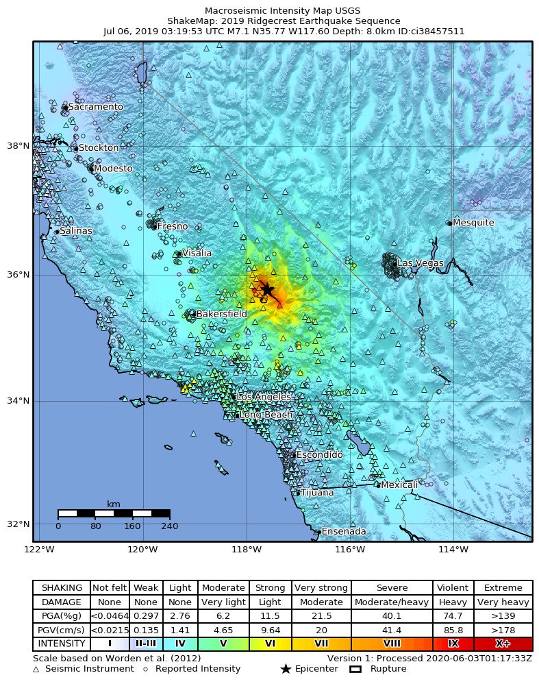
The USGS ShakeMap: shaking estimated from seismic stations and the quake’s size, on the Modified Mercalli intensity scale.
- Strongest estimated
- IX, violent shaking
- Peak ground acceleration
- 73.5% of gravity
- Peak ground velocity
- 4.6 cm/s
- Map
- Automatic
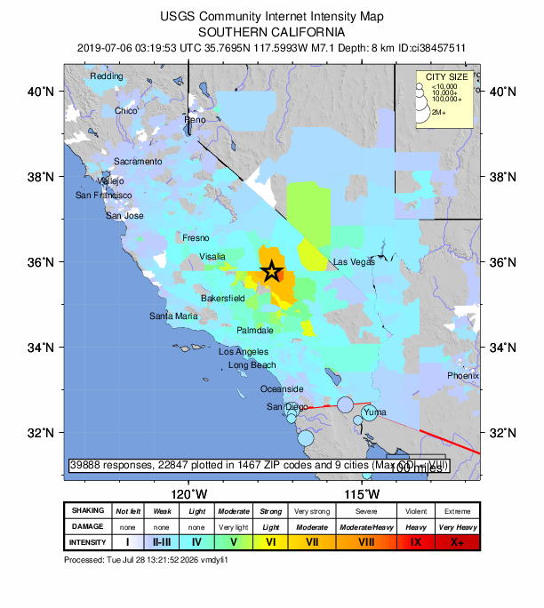
Did you feel it?
39,888 people reported to the USGS what they felt; the strongest reported shaking was IX, violent shaking.
Estimated impact
The USGS PAGER system estimates deaths and economic losses from the shaking and the population and buildings exposed to it.
- Alert level
- Yellow: some damage and deaths possible, a local or regional response
| Range | Chance |
|---|---|
| Under 1 | 65% |
| 1 to 10 | 30% |
| 10 to 100 | 4% |
| 100 to 1,000 | Under 1% |
| 1,000 to 10,000 | Under 1% |
| 10,000 to 100,000 | Under 1% |
| 100,000 to 10,000,000 | Under 1% |
| Range, million USD | Chance |
|---|---|
| Under 1 | 8% |
| 1 to 10 | 23% |
| 10 to 100 | 35% |
| 100 to 1,000 | 25% |
| 1,000 to 10,000 | 8% |
| 10,000 to 100,000 | 1% |
| 100,000 to 10,000,000 | Under 1% |
Aftershock forecast
The chance of at least one aftershock this large or larger, from the USGS operational aftershock forecast, issued Thu, Sep 3, 2026, 3:19 AM UTC. The USGS updates it as the sequence unfolds.
| Within | M3+ | M4+ | M5+ | M6+ | M7+ |
|---|---|---|---|---|---|
| 1 day | 2% | Under 1% | Under 1% | Under 1% | Under 1% |
| 1 week | 12% | 1% | Under 1% | Under 1% | Under 1% |
| 1 month | 43% | 5% | Under 1% | Under 1% | Under 1% |
| 1 year | Over 99% | 47% | 6% | Under 1% | Under 1% |
In the coming week the USGS expects about 0 aftershocks of magnitude 3 or more, and most likely between 0 and 1.
Fault motion and ground failure
How the rock slipped, from the moment tensor, and the USGS estimate of landslides and liquefaction.
- Landslide alert
- Yellow
- Liquefaction alert
- Yellow
How well it is located
Reviewed by a seismologist.
- Location uncertainty
- About 0.2 km horizontally, 31.6 km in depth
- Magnitude uncertainty
- ±0.03
- Depth from
- Operator assigned
- Station coverage gap
- 43°
- Stations used
- 77
Nearest places
Distance and direction from each place to the epicenter, with its forecast.
Nearby
Within 100 km, magnitude 2.5 and up: 200 in the 60 days after this one and 0 in the 30 days before it.
After
- 2.515km ESE of Little Lake, CA · 2613 days ago · 7 km deep · 20 km away
- 2.915km NE of Ridgecrest, CA · 2613 days ago · 10 km deep · 4 km away · felt by 14
- 2.515km SW of Searles Valley, CA · 2612 days ago · 10 km deep · 15 km away · felt by 2
- 2.825km N of Searles Valley, CA · 2612 days ago · 1 km deep · 30 km away
- 3.014km ENE of Ridgecrest, CA · 2612 days ago · 4 km deep · 10 km away · felt by 7
- 2.722km E of Little Lake, CA · 2612 days ago · 3 km deep · 20 km away
- 2.816km E of Ridgecrest, CA · 2612 days ago · 4 km deep · 16 km away · felt by 1
- 2.721km N of Trona, CA · 2612 days ago · 3 km deep · 31 km away · felt by 3
- 2.614km WSW of Searles Valley, CA · 2612 days ago · 8 km deep · 10 km away · felt by 1
- 3.319km SE of Little Lake, CA · 2612 days ago · 5 km deep · 15 km away · felt by 2
- 3.522km WNW of Searles Valley, CA · 2612 days ago · 6 km deep · 7 km away · felt by 17
- 3.119km E of Little Lake, CA · 2612 days ago · 4 km deep · 19 km away · felt by 2
- 2.621km N of Trona, CA · 2612 days ago · 3 km deep · 31 km away · felt by 4
- 2.79km ENE of Coso Junction, CA · 2612 days ago · 2 km deep · 41 km away
- 2.622km E of Little Lake, CA · 2612 days ago · 3 km deep · 20 km away
- 2.628km N of Searles Valley, CA · 2611 days ago · 4 km deep · 35 km away
- 2.716km E of Ridgecrest, CA · 2611 days ago · 10 km deep · 17 km away
- 3.514km SW of Searles Valley, CA · 2611 days ago · 10 km deep · 14 km away · felt by 76
- 2.713km WSW of Searles Valley, CA · 2610 days ago · 2 km deep · 7 km away
- 2.813km ENE of Ridgecrest, CA · 2610 days ago · 9 km deep · 13 km away · felt by 1
- 2.613km WSW of Searles Valley, CA · 2610 days ago · 10 km deep · 9 km away
- 2.814km NNE of Coso Junction, CA · 2610 days ago · 1 km deep · 50 km away · felt by 2
- 3.131km W of Olancha, CA · 2610 days ago · -1 km deep · 91 km away · felt by 4
- 2.814km ENE of Ridgecrest, CA · 2610 days ago · 10 km deep · 13 km away
- 2.614km SSW of Searles Valley, CA · 2610 days ago · 3 km deep · 18 km away · felt by 1
- 3.218km E of Little Lake, CA · 2609 days ago · 3 km deep · 23 km away · felt by 2
- 2.88km WSW of Searles Valley, CA · 2609 days ago · 7 km deep · 12 km away · felt by 2
- 2.88km NE of Coso Junction, CA · 2609 days ago · 3 km deep · 43 km away · felt by 3
- 2.522km E of Little Lake, CA · 2609 days ago · 2 km deep · 16 km away · felt by 1
- 2.67km NE of Coso Junction, CA · 2609 days ago · 5 km deep · 45 km away · felt by 1
- 2.819km E of Little Lake, CA · 2609 days ago · 3 km deep · 19 km away
- 2.510km SW of Searles Valley, CA · 2609 days ago · 7 km deep · 11 km away · felt by 4
- 3.114km SE of Olancha, CA · 2609 days ago · 1 km deep · 54 km away · felt by 3
- 2.536km N of Trona, CA · 2609 days ago · 2 km deep · 44 km away · felt by 2
- 2.615km SW of Searles Valley, CA · 2609 days ago · 9 km deep · 13 km away · felt by 2
- 3.519km NNE of Ridgecrest, CA · 2608 days ago · 8 km deep · 2 km away · felt by 38
- 2.811km SW of Searles Valley, CA · 2608 days ago · 8 km deep · 11 km away · felt by 3
- 2.718km E of Little Lake, CA · 2608 days ago · 2 km deep · 19 km away · felt by 1
- 3.317km SSW of Searles Valley, CA · 2608 days ago · 3 km deep · 21 km away · felt by 7
- 2.511km WSW of Searles Valley, CA · 2608 days ago · 5 km deep · 11 km away
- 2.515km W of Searles Valley, CA · 2608 days ago · 2 km deep · 3 km away
- 2.715km SSW of Searles Valley, CA · 2608 days ago · 3 km deep · 21 km away
- 2.820km ESE of Little Lake, CA · 2607 days ago · 5 km deep · 14 km away · felt by 1
- 2.714km SSW of Searles Valley, CA · 2607 days ago · 4 km deep · 16 km away · felt by 2
- 2.614km SW of Searles Valley, CA · 2607 days ago · 4 km deep · 15 km away
- 3.132km N of Searles Valley, CA · 2607 days ago · 2 km deep · 38 km away
- 2.521km S of Trona, CA · 2607 days ago · 3 km deep · 31 km away
- 2.78km SW of Searles Valley, CA · 2607 days ago · 6 km deep · 12 km away
- 2.626km S of Trona, CA · 2606 days ago · 9 km deep · 34 km away
- 3.323km ESE of Little Lake, CA · 2606 days ago · 5 km deep · 11 km away · felt by 3
- 2.715km S of Searles Valley, CA · 2606 days ago · 3 km deep · 21 km away
- 2.615km S of Searles Valley, CA · 2606 days ago · 4 km deep · 21 km away
- 2.520km ESE of Little Lake, CA · 2606 days ago · 5 km deep · 14 km away · felt by 1
- 2.716km S of Searles Valley, CA · 2606 days ago · 4 km deep · 22 km away · felt by 1
- 2.613km ENE of Ridgecrest, CA · 2605 days ago · 8 km deep · 11 km away
- 2.613km WSW of Searles Valley, CA · 2605 days ago · 3 km deep · 7 km away
- 2.824km S of Trona, CA · 2604 days ago · 9 km deep · 33 km away
- 2.814km ENE of Ridgecrest, CA · 2604 days ago · 8 km deep · 12 km away · felt by 1
- 2.621km WNW of Searles Valley, CA · 2604 days ago · 1 km deep · 5 km away · felt by 4
- 2.618km S of Trona, CA · 2604 days ago · 8 km deep · 25 km away
The first 60 of 200.
Earthquakes todayCalifornia earthquakesLive radar here
Sources
From the USGS Earthquake Hazards Program and its partner networks, event ci38457511 (also filed as us70004bn0, at00pu7alg, pt19187000, iscgem616203758). Read Tue, Sep 22, 2026, 9:19 PM UTC.