M3.0 earthquake 6 km SSE of Amber, Oklahoma
A magnitude 3.0 earthquake struck 6 km SSE of Amber, Oklahoma on Tue, Feb 19, 2019, 12:08 PM CST (18:08 UTC), 5 km (3 mi) below the surface.
A larger quake followed: M3.1 11 km NW of Edmond, Oklahoma. This one was a foreshock.
Map
Where this earthquake was located, with the others nearby. Select one for its page.
The earthquake
- Magnitude
- 3.0 (mb_lg), minor
- Local time
- UTC
- 2019-02-19 18:08:10 UTC
- Depth
- 5.0 km (3.1 mi), shallow
- Epicenter
- 35.105° N, 97.862° W
- Region
- Oklahoma
- Felt reports
- 44
- Tsunami flag
- No
- Status
- Reviewed by a seismologist
Did you feel it?
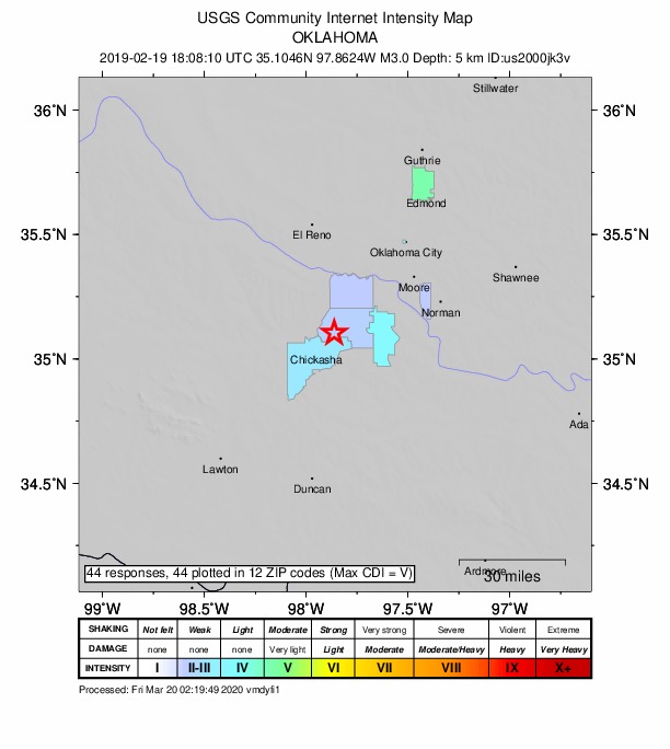
44 people reported to the USGS what they felt; the strongest reported shaking was V, moderate shaking.
How well it is located
Reviewed by a seismologist.
- Location uncertainty
- About 0.9 km horizontally, 1.8 km in depth
- Magnitude uncertainty
- ±0.05
- Depth from
- Operator assigned
- Station coverage gap
- 87°
- Stations used
- 47
Nearest places
Distance and direction from each place to the epicenter, with its forecast.
Nearby
Within 100 km, magnitude 1.5 and up: 59 in the 60 days after this one and 22 in the 30 days before it.
After
- 2.66 km SSE of Amber, Oklahoma · 2771 days ago · 5 km deep · 0 km away · felt by 1
- 2.73 km S of Amber, Oklahoma · 2770 days ago · 5 km deep · 3 km away · felt by 6
- 1.84 km ENE of Blanchard, Oklahoma · 2767 days ago · 5 km deep · 24 km away · felt by 3
- 2.64 km NNW of Cole, Oklahoma · 2767 days ago · 5 km deep · 26 km away · felt by 60
- 1.92 km N of Cole, Oklahoma · 2765 days ago · 5 km deep · 26 km away · felt by 8
- 2.33 km E of Blanchard, Oklahoma · 2765 days ago · 5 km deep · 22 km away · felt by 10
- 3.111 km NW of Edmond, Oklahoma · 2762 days ago · 5 km deep · 75 km away · felt by 144
- 2.07 km ENE of Amber, Oklahoma · 2761 days ago · 5 km deep · 10 km away · felt by 1
- 1.811 km NW of Edmond, Oklahoma · 2761 days ago · 5 km deep · 75 km away · felt by 3
- 1.811 km SE of Cashion, Oklahoma · 2761 days ago · 5 km deep · 75 km away
- 1.83 km SE of Cole, Oklahoma · 2759 days ago · 5 km deep · 29 km away · felt by 1
- 2.316 km E of Watonga, Oklahoma · 2759 days ago · 6 km deep · 88 km away
- 1.916 km E of Watonga, Oklahoma · 2758 days ago · 6 km deep · 88 km away
- 2.07 km SW of Loyal, Oklahoma · 2758 days ago · 5 km deep · 95 km away
- 1.616 km E of Watonga, Oklahoma · 2758 days ago · 6 km deep · 88 km away
- 2.216 km E of Watonga, Oklahoma · 2758 days ago · 8 km deep · 88 km away
- 1.813 km ESE of Dover, Oklahoma · 2757 days ago · 5 km deep · 95 km away
- 2.84 km E of Blanchard, Oklahoma · 2756 days ago · 7 km deep · 24 km away · felt by 11
- 2.38 km SE of Loyal, Oklahoma · 2753 days ago · 7 km deep · 92 km away
- 1.89 km NE of Velma, Oklahoma · 2753 days ago · 6 km deep · 68 km away
- 1.83 km E of Blanchard, Oklahoma · 2752 days ago · 5 km deep · 22 km away · felt by 1
- 2.511 km NW of Edmond, Oklahoma · 2750 days ago · 7 km deep · 76 km away · felt by 17
- 2.48 km WNW of Minco, Oklahoma · 2747 days ago · 5 km deep · 31 km away
- 1.77 km SE of Loyal, Oklahoma · 2746 days ago · 6 km deep · 93 km away
- 1.77 km SE of Loyal, Oklahoma · 2746 days ago · 6 km deep · 92 km away
- 3.012 km NW of Edmond, Oklahoma · 2746 days ago · 6 km deep · 75 km away · felt by 93
- 2.74 km S of Cole, Oklahoma · 2744 days ago · 5 km deep · 27 km away · felt by 21
- 1.58 km SE of Loyal, Oklahoma · 2742 days ago · 5 km deep · 92 km away
- 2.09 km SE of Loyal, Oklahoma · 2742 days ago · 6 km deep · 92 km away
- 2.19 km SE of Loyal, Oklahoma · 2741 days ago · 7 km deep · 92 km away
- 2.09 km SE of Loyal, Oklahoma · 2740 days ago · 7 km deep · 92 km away
- 2.09 km SE of Loyal, Oklahoma · 2740 days ago · 7 km deep · 91 km away
- 2.39 km SE of Loyal, Oklahoma · 2739 days ago · 7 km deep · 92 km away
- 2.19 km SE of Loyal, Oklahoma · 2738 days ago · 7 km deep · 92 km away
- 2.81 km NNW of Cole, Oklahoma · 2738 days ago · 5 km deep · 26 km away · felt by 65
- 2.29 km SE of Loyal, Oklahoma · 2738 days ago · 7 km deep · 92 km away
- 2.09 km SE of Loyal, Oklahoma · 2737 days ago · 6 km deep · 91 km away
- 1.82 km W of Ninnekah, Oklahoma · 2736 days ago · 5 km deep · 20 km away
- 2.59 km SE of Loyal, Oklahoma · 2736 days ago · 6 km deep · 92 km away
- 2.83 km SSW of Amber, Oklahoma · 2735 days ago · 5 km deep · 4 km away · felt by 8
- 1.83 km NW of Cole, Oklahoma · 2735 days ago · 5 km deep · 24 km away · felt by 8
- 1.92 km WSW of Cole, Oklahoma · 2735 days ago · 5 km deep · 24 km away · felt by 10
- 2.31 km WNW of Cole, Oklahoma · 2733 days ago · 5 km deep · 25 km away · felt by 5
- 2.70 km SE of Cole, Oklahoma · 2730 days ago · 5 km deep · 27 km away · felt by 23
- 2.415 km SSW of Loyal, Oklahoma · 2728 days ago · 5 km deep · 88 km away
- 1.89 km SE of Loyal, Oklahoma · 2727 days ago · 6 km deep · 92 km away
- 2.59 km SE of Loyal, Oklahoma · 2727 days ago · 7 km deep · 91 km away
- 1.89 km SE of Loyal, Oklahoma · 2726 days ago · 6 km deep · 91 km away
- 1.69 km SE of Loyal, Oklahoma · 2726 days ago · 7 km deep · 91 km away
- 1.85 km W of Arcadia, Oklahoma · 2726 days ago · 7 km deep · 77 km away
- 2.015 km SSW of Loyal, Oklahoma · 2725 days ago · 7 km deep · 88 km away
- 1.9Oklahoma · 2723 days ago · 7 km deep · 88 km away
- 1.615 km SSW of Loyal, Oklahoma · 2723 days ago · 7 km deep · 88 km away
- 1.915 km SSW of Loyal, Oklahoma · 2723 days ago · 7 km deep · 89 km away
- 2.415 km SSW of Loyal, Oklahoma · 2719 days ago · 7 km deep · 88 km away
- 1.715 km SSW of Loyal, Oklahoma · 2719 days ago · 6 km deep · 89 km away
- 1.816 km SSW of Loyal, Oklahoma · 2718 days ago · 7 km deep · 88 km away
- 2.52 km ESE of Minco, Oklahoma · 2718 days ago · 5 km deep · 22 km away · felt by 1
- 1.85 km N of Bridge Creek, Oklahoma · 2713 days ago · 5 km deep · 23 km away · felt by 3
Before
- 2.27 km S of Amber, Oklahoma · 2772 days ago · 12 km deep · 1 km away
- 2.34 km S of Amber, Oklahoma · 2774 days ago · 5 km deep · 2 km away
- 2.69 km NNE of Harrah, Oklahoma · 2775 days ago · 6 km deep · 85 km away · felt by 1
- 3.48 km NNE of Harrah, Oklahoma · 2778 days ago · 5 km deep · 85 km away · felt by 79
- 2.16 km S of Amber, Oklahoma · 2778 days ago · 5 km deep · 2 km away · felt by 3
- 1.913 km ESE of Watonga, Oklahoma · 2779 days ago · 5 km deep · 88 km away
- 2.24 km SW of Tuttle, Oklahoma · 2780 days ago · 5 km deep · 18 km away · felt by 7
- 2.55 km S of Amber, Oklahoma · 2780 days ago · 5 km deep · 1 km away · felt by 7
- 2.214 km ESE of Watonga, Oklahoma · 2780 days ago · 5 km deep · 87 km away
- 2.3Oklahoma · 2781 days ago · 10 km deep · 88 km away
- 2.45 km S of Amber, Oklahoma · 2785 days ago · 5 km deep · 3 km away · felt by 2
- 2.75 km S of Amber, Oklahoma · 2785 days ago · 5 km deep · 2 km away · felt by 6
- 2.13 km WNW of Alex, Oklahoma · 2785 days ago · 5 km deep · 20 km away · felt by 1
- 2.21 km NE of Wayne, Oklahoma · 2790 days ago · 5 km deep · 55 km away
- 2.510 km S of Okarche, Oklahoma · 2791 days ago · 5 km deep · 60 km away
- 2.46 km SSE of Guthrie, Oklahoma · 2796 days ago · 6 km deep · 91 km away
- 2.45 km SW of Tuttle, Oklahoma · 2797 days ago · 5 km deep · 17 km away · felt by 3
- 2.37 km WSW of Tuttle, Oklahoma · 2797 days ago · 5 km deep · 18 km away · felt by 4
- 2.31 km NW of Wayne, Oklahoma · 2797 days ago · 5 km deep · 52 km away
- 2.35 km WSW of Tuttle, Oklahoma · 2799 days ago · 5 km deep · 19 km away · felt by 1
Earthquakes todayOklahoma earthquakesLive radar here
Sources
From the USGS Earthquake Hazards Program and its partner networks, event us2000jk3v. Read Tue, Sep 22, 2026, 5:30 AM UTC.