M3.3 earthquake 9 km W of Red Rock, Oklahoma
A magnitude 3.3 earthquake struck 9 km W of Red Rock, Oklahoma on Tue, Jun 27, 2017, 1:07 AM CDT (06:07 UTC), 5 km (3 mi) below the surface.
A larger quake followed: M3.4 6 km N of Maramec, Oklahoma. This one was a foreshock.
Map
Where this earthquake was located, with the others nearby. Select one for its page.
The earthquake
- Magnitude
- 3.3 (mb_lg), minor
- Local time
- UTC
- 2017-06-27 06:07:54 UTC
- Depth
- 5.0 km (3.1 mi), shallow
- Epicenter
- 36.472° N, 97.285° W
- Region
- Oklahoma
- Felt reports
- 13
- Tsunami flag
- No
- Status
- Reviewed by a seismologist
Did you feel it?
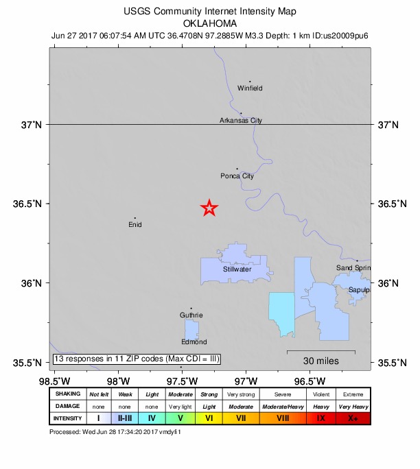
13 people reported to the USGS what they felt; the strongest reported shaking was III, weak shaking.
How well it is located
Reviewed by a seismologist.
- Location uncertainty
- About 1.7 km horizontally, 2.0 km in depth
- Magnitude uncertainty
- ±0.05
- Depth from
- Operator assigned
- Station coverage gap
- 26°
- Stations used
- 62
Nearest places
Distance and direction from each place to the epicenter, with its forecast.
Nearby
Within 100 km, magnitude 1.5 and up: 198 in the 60 days after this one and 1 in the 30 days before it.
After
- 2.64 km N of Stroud, Oklahoma · 3374 days ago · 3 km deep · 95 km away · felt by 3
- 2.69 km NNW of Arcadia, Oklahoma · 3374 days ago · 6 km deep · 82 km away · felt by 4
- 2.613 km NNW of Pawnee, Oklahoma · 3371 days ago · 5 km deep · 36 km away
- 3.25 km N of Coyle, Oklahoma · 3371 days ago · 4 km deep · 52 km away · felt by 11
- 3.12 km ENE of Jet, Oklahoma · 3370 days ago · 5 km deep · 81 km away · felt by 2
- 2.114 km NNW of Pawnee, Oklahoma · 3370 days ago · 3 km deep · 35 km away · felt by 1
- 2.52 km S of Medford, Oklahoma · 3370 days ago · 4 km deep · 53 km away · felt by 1
- 2.39 km ESE of Jefferson, Oklahoma · 3369 days ago · 6 km deep · 44 km away
- 2.63 km ESE of Meno, Oklahoma · 3368 days ago · 5 km deep · 78 km away
- 2.62 km SSE of Carney, Oklahoma · 3367 days ago · 6 km deep · 81 km away · felt by 6
- 2.74 km NW of Jet, Oklahoma · 3367 days ago · 9 km deep · 87 km away · felt by 1
- 2.85 km SSW of Medford, Oklahoma · 3366 days ago · 4 km deep · 54 km away · felt by 1
- 2.411 km NW of Pawnee, Oklahoma · 3365 days ago · 4 km deep · 37 km away
- 3.15 km SSW of Medford, Oklahoma · 3365 days ago · 6 km deep · 54 km away · felt by 11
- 3.46 km N of Maramec, Oklahoma · 3364 days ago · 7 km deep · 56 km away · felt by 11
- 2.813 km NW of Pawnee, Oklahoma · 3363 days ago · 4 km deep · 33 km away · felt by 1
- 2.813 km NW of Pawnee, Oklahoma · 3363 days ago · 4 km deep · 34 km away
- 2.12 km E of Luther, Oklahoma · 3363 days ago · 5 km deep · 90 km away · felt by 1
- 2.87 km SW of Helena, Oklahoma · 3362 days ago · 6 km deep · 94 km away · felt by 2
- 2.27 km SSW of Helena, Oklahoma · 3362 days ago · 5 km deep · 92 km away
- 2.04 km NNW of Bluff City, Kansas · 3360 days ago · 5 km deep · 90 km away
- 3.06 km N of Maramec, Oklahoma · 3360 days ago · 3 km deep · 58 km away · felt by 1
- 2.64 km ENE of Covington, Oklahoma · 3360 days ago · 7 km deep · 28 km away · felt by 2
- 2.58 km SSE of Luther, Oklahoma · 3359 days ago · 4 km deep · 99 km away
- 2.06 km SSE of Argonia, Kansas · 3359 days ago · 7 km deep · 91 km away
- 3.34 km WNW of Lucien, Oklahoma · 3359 days ago · 3 km deep · 29 km away · felt by 7
- 2.25 km W of Lucien, Oklahoma · 3358 days ago · 2 km deep · 30 km away
- 2.65 km N of Maramec, Oklahoma · 3358 days ago · 3 km deep · 57 km away · felt by 1
- 1.97 km SSW of Anthony, Kansas · 3358 days ago · 5 km deep · 97 km away
- 2.86 km N of Dover, Oklahoma · 3357 days ago · 4 km deep · 74 km away
- 4.210 km WSW of Shamrock, Oklahoma · 3357 days ago · 7 km deep · 87 km away · felt by 1,785
- 2.911 km NE of Kendrick, Oklahoma · 3357 days ago · 5 km deep · 86 km away · felt by 1
- 3.510 km WSW of Shamrock, Oklahoma · 3357 days ago · 7 km deep · 87 km away · felt by 13
- 3.610 km WSW of Shamrock, Oklahoma · 3357 days ago · 7 km deep · 87 km away · felt by 552
- 2.711 km WSW of Shamrock, Oklahoma · 3357 days ago · 7 km deep · 86 km away · felt by 2
- 3.410 km NE of Kendrick, Oklahoma · 3357 days ago · 5 km deep · 86 km away · felt by 91
- 3.06 km N of Dover, Oklahoma · 3357 days ago · 5 km deep · 74 km away · felt by 12
- 2.610 km WSW of Shamrock, Oklahoma · 3357 days ago · 5 km deep · 86 km away
- 2.75 km N of Dover, Oklahoma · 3357 days ago · 6 km deep · 74 km away · felt by 17
- 2.45 km N of Dover, Oklahoma · 3357 days ago · 4 km deep · 74 km away · felt by 9
- 2.29 km E of Medford, Oklahoma · 3357 days ago · 8 km deep · 49 km away · felt by 13
- 2.46 km N of Dover, Oklahoma · 3357 days ago · 8 km deep · 73 km away
- 2.55 km W of Arcadia, Oklahoma · 3356 days ago · 6 km deep · 90 km away · felt by 24
- 2.612 km N of Coyle, Oklahoma · 3356 days ago · 4 km deep · 45 km away · felt by 2
- 3.010 km WSW of Shamrock, Oklahoma · 3356 days ago · 3 km deep · 87 km away · felt by 4
- 2.74 km SE of Marshall, Oklahoma · 3356 days ago · 4 km deep · 47 km away · felt by 1
- 3.210 km WSW of Shamrock, Oklahoma · 3354 days ago · 7 km deep · 87 km away · felt by 1
- 3.310 km E of Red Rock, Oklahoma · 3354 days ago · 6 km deep · 20 km away · felt by 5
- 1.99 km W of Bluff City, Kansas · 3353 days ago · 8 km deep · 91 km away
- 2.3Kansas · 3353 days ago · 7 km deep · 91 km away
- 1.69 km W of Bluff City, Kansas · 3353 days ago · 8 km deep · 91 km away
- 3.210 km WSW of Shamrock, Oklahoma · 3353 days ago · 6 km deep · 87 km away · felt by 12
- 3.210 km SW of Stillwater, Oklahoma · 3353 days ago · 6 km deep · 50 km away · felt by 34
- 2.59 km WSW of Lucien, Oklahoma · 3352 days ago · 7 km deep · 36 km away · felt by 1
- 1.89 km SSE of Anthony, Kansas · 3352 days ago · 8 km deep · 91 km away
- 1.67 km ESE of Bluff City, Kansas · 3352 days ago · 5 km deep · 78 km away
- 2.46 km E of Manchester, Oklahoma · 3352 days ago · 7 km deep · 84 km away
- 2.39 km NE of Kendrick, Oklahoma · 3351 days ago · 5 km deep · 87 km away
- 2.69 km W of Bluff City, Kansas · 3351 days ago · 8 km deep · 91 km away
- 3.35 km N of Stroud, Oklahoma · 3350 days ago · 6 km deep · 94 km away · felt by 9
The first 60 of 198.
Before
Earthquakes todayOklahoma earthquakesLive radar here
Sources
From the USGS Earthquake Hazards Program and its partner networks, event us20009pu6. Read Tue, Sep 22, 2026, 2:48 PM UTC.