M3.2 earthquake 3 km SE of Meno, Oklahoma
A magnitude 3.2 earthquake struck 3 km SE of Meno, Oklahoma on Thu, Apr 20, 2017, 8:38 AM CDT (13:38 UTC), 5 km (3 mi) below the surface.
A larger quake followed: M3.6 9 km W of Lamont, Oklahoma. This one was a foreshock.
Map
Where this earthquake was located, with the others nearby. Select one for its page.
The earthquake
- Magnitude
- 3.2 (ml), minor
- Local time
- UTC
- 2017-04-20 13:38:14 UTC
- Depth
- 4.9 km (3.0 mi), shallow
- Epicenter
- 36.361° N, 98.157° W
- Region
- Oklahoma
- Felt reports
- 2
- Tsunami flag
- No
- Status
- Reviewed by a seismologist
Did you feel it?
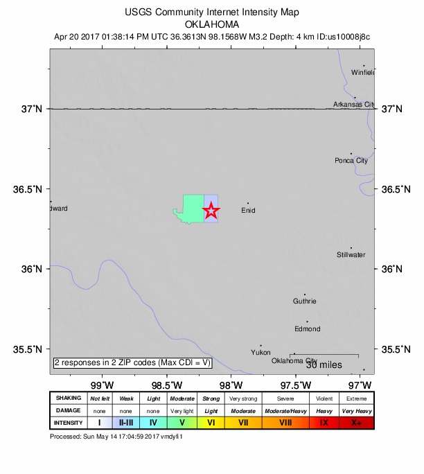
2 people reported to the USGS what they felt; the strongest reported shaking was V, moderate shaking.
How well it is located
Reviewed by a seismologist.
- Location uncertainty
- About 1.2 km horizontally, 7.7 km in depth
- Station coverage gap
- 40°
- Stations used
- 0
Nearest places
Distance and direction from each place to the epicenter, with its forecast.
Nearby
Within 100 km, magnitude 1.5 and up: 177 in the 60 days after this one and 22 in the 30 days before it.
After
- 2.55 km WNW of Medford, Oklahoma · 3441 days ago · 8 km deep · 62 km away · felt by 2
- 2.33 km NNW of Freeport, Kansas · 3440 days ago · 3 km deep · 100 km away
- 2.59 km W of Lamont, Oklahoma · 3440 days ago · 3 km deep · 58 km away
- 3.0Oklahoma · 3440 days ago · 6 km deep · 58 km away · felt by 1
- 3.69 km W of Lamont, Oklahoma · 3440 days ago · 8 km deep · 58 km away · felt by 7
- 1.72 km E of Anthony, Kansas · 3438 days ago · 6 km deep · 89 km away
- 2.65 km WNW of Medford, Oklahoma · 3438 days ago · 6 km deep · 62 km away
- 1.910 km N of Caldwell, Kansas · 3438 days ago · 4 km deep · 99 km away
- 3.38 km ENE of Cherokee, Oklahoma · 3437 days ago · 3 km deep · 49 km away · felt by 5
- 1.82 km E of Anthony, Kansas · 3437 days ago · 6 km deep · 89 km away
- 2.010 km WNW of Caldwell, Kansas · 3437 days ago · 6 km deep · 88 km away
- 2.74 km WNW of Lucien, Oklahoma · 3437 days ago · 7 km deep · 59 km away
- 3.04 km WNW of Medford, Oklahoma · 3437 days ago · 1 km deep · 61 km away · felt by 1
- 3.016 km SE of Waynoka, Oklahoma · 3436 days ago · 8 km deep · 54 km away · felt by 1
- 2.43 km NW of Helena, Oklahoma · 3436 days ago · 4 km deep · 26 km away · felt by 1
- 3.010 km W of Lamont, Oklahoma · 3436 days ago · 6 km deep · 57 km away · felt by 2
- 2.28 km SE of Harper, Kansas · 3435 days ago · 4 km deep · 98 km away
- 1.76 km SSE of Bluff City, Kansas · 3435 days ago · 5 km deep · 79 km away
- 3.216 km SE of Waynoka, Oklahoma · 3434 days ago · 5 km deep · 56 km away · felt by 1
- 2.518 km SE of Waynoka, Oklahoma · 3434 days ago · 5 km deep · 55 km away
- 2.51 km ENE of Fairmont, Oklahoma · 3434 days ago · 6 km deep · 42 km away
- 2.29 km W of Bluff City, Kansas · 3434 days ago · 8 km deep · 80 km away
- 2.06 km SSE of Bluff City, Kansas · 3433 days ago · 5 km deep · 79 km away
- 1.93 km NNW of Freeport, Kansas · 3433 days ago · 4 km deep · 100 km away
- 3.310 km W of Lamont, Oklahoma · 3433 days ago · 9 km deep · 58 km away · felt by 15
- 2.79 km W of Lamont, Oklahoma · 3433 days ago · 8 km deep · 58 km away
- 2.34 km SE of Freeport, Kansas · 3432 days ago · 3 km deep · 95 km away
- 2.71 km NNW of Lambert, Oklahoma · 3432 days ago · 7 km deep · 45 km away · felt by 2
- 2.79 km E of Perry, Oklahoma · 3432 days ago · 6 km deep · 88 km away
- 2.610 km W of Lamont, Oklahoma · 3431 days ago · 8 km deep · 57 km away · felt by 3
- 2.22 km SE of Bluff City, Kansas · 3431 days ago · 6 km deep · 82 km away
- 2.98 km SSE of Hitchcock, Oklahoma · 3431 days ago · 7 km deep · 53 km away · felt by 1
- 2.610 km WNW of Red Rock, Oklahoma · 3430 days ago · 6 km deep · 79 km away
- 2.810 km W of Lamont, Oklahoma · 3430 days ago · 8 km deep · 57 km away · felt by 2
- 2.64 km SSE of Covington, Oklahoma · 3429 days ago · 5 km deep · 54 km away
- 1.69 km W of Bluff City, Kansas · 3429 days ago · 8 km deep · 81 km away
- 1.59 km W of Bluff City, Kansas · 3428 days ago · 8 km deep · 81 km away
- 2.69 km ENE of Hennessey, Oklahoma · 3428 days ago · 6 km deep · 41 km away
- 2.53 km NE of Avard, Oklahoma · 3428 days ago · 7 km deep · 67 km away
- 2.75 km WNW of Lucien, Oklahoma · 3428 days ago · 8 km deep · 59 km away · felt by 2
- 2.64 km E of Covington, Oklahoma · 3427 days ago · 8 km deep · 56 km away
- 2.64 km E of Covington, Oklahoma · 3427 days ago · 6 km deep · 56 km away
- 3.73 km NNW of Freeport, Kansas · 3427 days ago · 4 km deep · 100 km away · felt by 14
- 1.69 km W of Bluff City, Kansas · 3427 days ago · 8 km deep · 81 km away
- 3.08 km NE of Marshall, Oklahoma · 3427 days ago · 7 km deep · 55 km away
- 2.54 km NNE of Avard, Oklahoma · 3426 days ago · 5 km deep · 69 km away
- 2.513 km SSE of Waynoka, Oklahoma · 3426 days ago · 5 km deep · 59 km away · felt by 1
- 2.56 km SE of Perry, Oklahoma · 3426 days ago · 5 km deep · 84 km away
- 2.48 km S of Goltry, Oklahoma · 3425 days ago · 7 km deep · 11 km away · felt by 1
- 3.25 km NE of Hunter, Oklahoma · 3425 days ago · 6 km deep · 55 km away · felt by 2
- 3.010 km SSE of Waldron, Kansas · 3425 days ago · 10 km deep · 62 km away
- 1.89 km W of Bluff City, Kansas · 3424 days ago · 8 km deep · 81 km away
- 3.310 km SSE of Waldron, Kansas · 3424 days ago · 8 km deep · 62 km away · felt by 3
- 3.010 km SSE of Waldron, Kansas · 3424 days ago · 8 km deep · 62 km away · felt by 2
- 3.46 km NE of Hunter, Oklahoma · 3423 days ago · 8 km deep · 56 km away · felt by 15
- 2.48 km NNE of Nardin, Oklahoma · 3422 days ago · 8 km deep · 87 km away
- 1.79 km W of Bluff City, Kansas · 3421 days ago · 8 km deep · 80 km away
- 1.54 km ESE of Caldwell, Kansas · 3421 days ago · 6 km deep · 90 km away
- 2.79 km WSW of Waynoka, Oklahoma · 3420 days ago · 6 km deep · 75 km away
- 2.52 km NW of Chester, Oklahoma · 3420 days ago · 6 km deep · 72 km away
The first 60 of 177.
Before
- 3.19 km W of Lamont, Oklahoma · 3442 days ago · 8 km deep · 58 km away · felt by 3
- 2.51 km SSE of Hennessey, Oklahoma · 3443 days ago · 6 km deep · 38 km away
- 1.611 km NNW of Caldwell, Kansas · 3443 days ago · 5 km deep · 97 km away
- 2.56 km WSW of Morrison, Oklahoma · 3444 days ago · 5 km deep · 98 km away
- 3.07 km SSE of Lucien, Oklahoma · 3444 days ago · 8 km deep · 68 km away · felt by 3
- 2.79 km W of Bluff City, Kansas · 3444 days ago · 8 km deep · 80 km away · felt by 1
- 2.59 km W of Bluff City, Kansas · 3444 days ago · 7 km deep · 81 km away
- 2.714 km WNW of Canton, Oklahoma · 3444 days ago · 5 km deep · 58 km away
- 1.65 km SSE of Freeport, Kansas · 3445 days ago · 4 km deep · 93 km away
- 2.87 km NNW of Orlando, Oklahoma · 3445 days ago · 8 km deep · 68 km away · felt by 2
- 2.76 km SW of Okarche, Oklahoma · 3445 days ago · 6 km deep · 77 km away
- 1.52 km NE of Caldwell, Kansas · 3445 days ago · 5 km deep · 92 km away
- 3.17 km NNW of Orlando, Oklahoma · 3446 days ago · 6 km deep · 68 km away
- 2.52 km SW of Waldron, Kansas · 3446 days ago · 4 km deep · 70 km away
- 3.57 km NNW of Orlando, Oklahoma · 3446 days ago · 8 km deep · 68 km away · felt by 12
- 2.36 km SW of Okarche, Oklahoma · 3447 days ago · 7 km deep · 76 km away · felt by 1
- 2.93 km NNW of Freeport, Kansas · 3448 days ago · 4 km deep · 99 km away · felt by 2
- 3.110 km W of Lamont, Oklahoma · 3449 days ago · 9 km deep · 57 km away · felt by 2
- 3.210 km W of Lamont, Oklahoma · 3449 days ago · 10 km deep · 58 km away · felt by 9
- 2.26 km NE of Watonga, Oklahoma · 3449 days ago · 8 km deep · 56 km away
Earthquakes todayOklahoma earthquakesLive radar here
Sources
From the USGS Earthquake Hazards Program and its partner networks, event us10008j8c. Read Tue, Sep 22, 2026, 7:23 AM UTC.