M5.1 earthquake 18 km SE of Waynoka, Oklahoma
A magnitude 5.1 earthquake struck 18 km SE of Waynoka, Oklahoma on Sat, Feb 13, 2016, 11:07 AM CST (17:07 UTC), 8 km (5 mi) below the surface.
Map
Where this earthquake was located, with the others nearby. Select one for its page.
The earthquake
- Magnitude
- 5.1 (mww), moderate
- Local time
- UTC
- 2016-02-13 17:07:06 UTC
- Depth
- 8.3 km (5.2 mi), shallow
- Epicenter
- 36.490° N, 98.709° W
- Region
- Oklahoma
- Felt reports
- 4,049
- Strongest shaking
- VII, very strong shaking
- PAGER alert
- Green
- Tsunami flag
- No
- Status
- Reviewed by a seismologist
Shaking
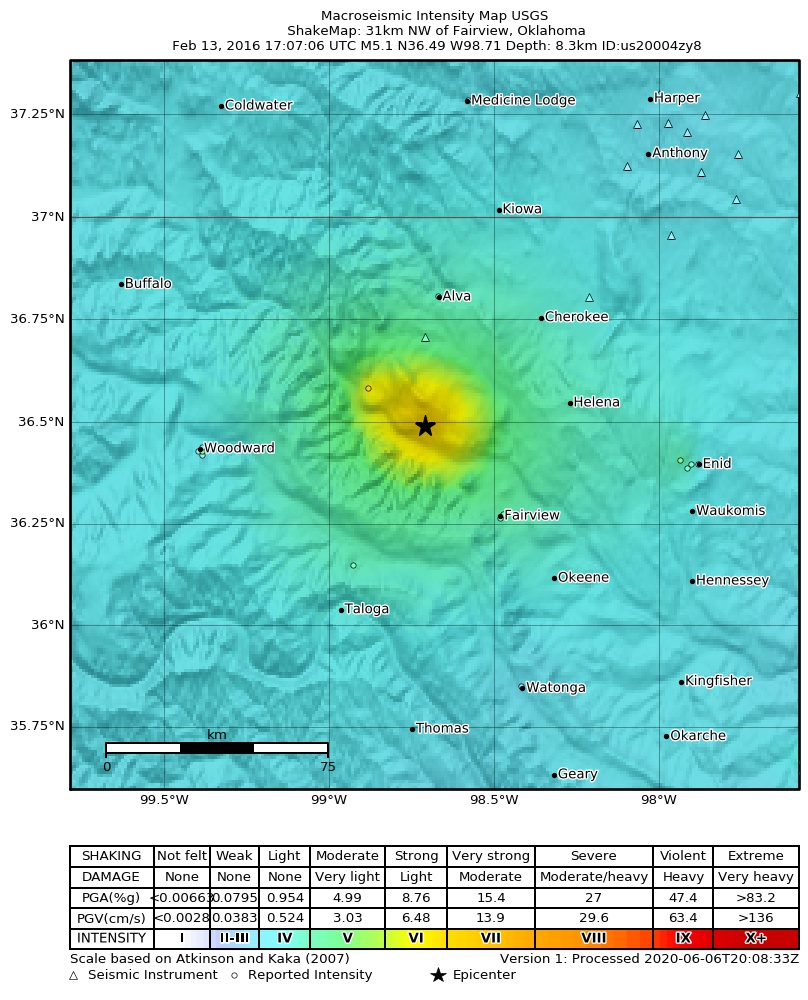
The USGS ShakeMap: shaking estimated from seismic stations and the quake’s size, on the Modified Mercalli intensity scale.
- Strongest estimated
- VII, very strong shaking
- Peak ground acceleration
- 30.9% of gravity
- Peak ground velocity
- 2.4 cm/s
- Map
- Automatic
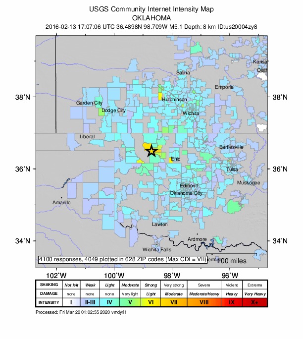
Did you feel it?
4,049 people reported to the USGS what they felt; the strongest reported shaking was VII, very strong shaking.
Estimated impact
The USGS PAGER system estimates deaths and economic losses from the shaking and the population and buildings exposed to it.
- Alert level
- Green: little or no damage or loss of life expected
Fault motion and ground failure
How the rock slipped, from the moment tensor, and the USGS estimate of landslides and liquefaction.
- Faulting
- Strike-slip
- Moment magnitude
- 5.1 Mww
- Nodal plane 1
- Strike 309°, dip 75°, rake -24°
- Nodal plane 2
- Strike 46°, dip 66°, rake -163°
How well it is located
Reviewed by a seismologist.
- Location uncertainty
- About 1.8 km horizontally, 3.7 km in depth
- Depth from
- From location
- Station coverage gap
- 17°
- Stations used
- 406
Nearest places
Distance and direction from each place to the epicenter, with its forecast.
Nearby
Within 100 km, magnitude 2.1 and up: 200 in the 60 days after this one and 0 in the 30 days before it.
After
- 3.416 km SE of Waynoka, Oklahoma · 3867 days ago · 7 km deep · 3 km away · felt by 2
- 2.217 km SE of Waynoka, Oklahoma · 3867 days ago · 7 km deep · 3 km away
- 2.71 km W of Douglas, Oklahoma · 3867 days ago · 4 km deep · 95 km away · felt by 1
- 2.916 km SE of Waynoka, Oklahoma · 3867 days ago · 7 km deep · 4 km away · felt by 1
- 2.216 km SE of Waynoka, Oklahoma · 3867 days ago · 5 km deep · 4 km away
- 2.216 km SE of Waynoka, Oklahoma · 3867 days ago · 5 km deep · 4 km away
- 2.117 km ESE of Waynoka, Oklahoma · 3866 days ago · 2 km deep · 5 km away
- 2.217 km SE of Waynoka, Oklahoma · 3866 days ago · 4 km deep · 3 km away
- 2.816 km SE of Waynoka, Oklahoma · 3866 days ago · 6 km deep · 7 km away · felt by 2
- 2.417 km SE of Waynoka, Oklahoma · 3865 days ago · 7 km deep · 7 km away · felt by 2
- 2.116 km SE of Waynoka, Oklahoma · 3865 days ago · 4 km deep · 4 km away
- 2.218 km SSE of Waynoka, Oklahoma · 3865 days ago · 4 km deep · 8 km away
- 2.616 km SE of Waynoka, Oklahoma · 3865 days ago · 8 km deep · 2 km away
- 3.416 km SSE of Waynoka, Oklahoma · 3865 days ago · 8 km deep · 7 km away · felt by 10
- 2.87 km E of Nescatunga, Oklahoma · 3864 days ago · 6 km deep · 64 km away
- 2.85 km E of Waukomis, Oklahoma · 3864 days ago · 7 km deep · 81 km away
- 2.65 km E of Waukomis, Oklahoma · 3864 days ago · 7 km deep · 81 km away
- 2.816 km SE of Waynoka, Oklahoma · 3864 days ago · 7 km deep · 4 km away · felt by 1
- 2.911 km SW of Wakita, Oklahoma · 3863 days ago · 5 km deep · 72 km away · felt by 1
- 2.315 km ESE of Waynoka, Oklahoma · 3863 days ago · 8 km deep · 3 km away
- 2.85 km E of Pond Creek, Oklahoma · 3863 days ago · 13 km deep · 89 km away · felt by 3
- 2.54 km SW of Bluff City, Kansas · 3862 days ago · 6 km deep · 94 km away · felt by 2
- 2.75 km SE of Fairview, Oklahoma · 3862 days ago · 7 km deep · 38 km away
- 2.94 km WSW of Kremlin, Oklahoma · 3862 days ago · 6 km deep · 74 km away
- 2.86 km SE of Fairview, Oklahoma · 3862 days ago · 7 km deep · 38 km away
- 2.218 km SSE of Waynoka, Oklahoma · 3862 days ago · 4 km deep · 9 km away
- 2.416 km SSE of Waynoka, Oklahoma · 3861 days ago · 5 km deep · 9 km away
- 2.317 km SE of Waynoka, Oklahoma · 3861 days ago · 5 km deep · 7 km away
- 3.110 km NE of Quinlan, Oklahoma · 3861 days ago · 7 km deep · 24 km away
- 2.910 km SW of Waynoka, Oklahoma · 3861 days ago · 6 km deep · 24 km away · felt by 1
- 2.318 km SE of Waynoka, Oklahoma · 3861 days ago · 6 km deep · 7 km away · felt by 1
- 2.69 km NE of Quinlan, Oklahoma · 3861 days ago · 6 km deep · 24 km away
- 2.710 km NW of Medford, Oklahoma · 3861 days ago · 5 km deep · 92 km away
- 2.118 km SSE of Waynoka, Oklahoma · 3861 days ago · 6 km deep · 8 km away
- 3.410 km E of Seiling, Oklahoma · 3861 days ago · 7 km deep · 41 km away
- 2.311 km N of Quinlan, Oklahoma · 3860 days ago · 5 km deep · 31 km away
- 2.53 km ESE of Fairmont, Oklahoma · 3860 days ago · 4 km deep · 94 km away · felt by 1
- 2.517 km SE of Waynoka, Oklahoma · 3860 days ago · 7 km deep · 4 km away
- 2.99 km SW of Waynoka, Oklahoma · 3860 days ago · 6 km deep · 24 km away · felt by 2
- 2.417 km SE of Waynoka, Oklahoma · 3859 days ago · 4 km deep · 4 km away
- 3.317 km SE of Waynoka, Oklahoma · 3859 days ago · 7 km deep · 4 km away
- 3.516 km SE of Waynoka, Oklahoma · 3859 days ago · 7 km deep · 4 km away · felt by 2
- 2.814 km SE of Waynoka, Oklahoma · 3859 days ago · 8 km deep · 6 km away
- 2.717 km SE of Waynoka, Oklahoma · 3859 days ago · 7 km deep · 5 km away
- 3.05 km E of Pond Creek, Oklahoma · 3859 days ago · 7 km deep · 88 km away
- 3.01 km SE of Breckinridge, Oklahoma · 3859 days ago · 6 km deep · 88 km away · felt by 1
- 2.817 km SSE of Waynoka, Oklahoma · 3859 days ago · 7 km deep · 8 km away
- 2.518 km SSE of Waynoka, Oklahoma · 3858 days ago · 6 km deep · 8 km away
- 2.68 km WNW of Medford, Oklahoma · 3858 days ago · 6 km deep · 88 km away · felt by 1
- 2.94 km NW of Douglas, Oklahoma · 3858 days ago · 6 km deep · 93 km away · felt by 1
- 3.69 km NE of Quinlan, Oklahoma · 3858 days ago · 7 km deep · 25 km away
- 3.39 km NE of Quinlan, Oklahoma · 3858 days ago · 7 km deep · 25 km away
- 2.118 km SSE of Waynoka, Oklahoma · 3858 days ago · 5 km deep · 8 km away
- 2.517 km SSE of Waynoka, Oklahoma · 3858 days ago · 7 km deep · 9 km away · felt by 2
- 2.617 km ESE of Waynoka, Oklahoma · 3858 days ago · 6 km deep · 4 km away
- 2.817 km SSE of Waynoka, Oklahoma · 3857 days ago · 7 km deep · 8 km away · felt by 1
- 2.617 km SE of Waynoka, Oklahoma · 3856 days ago · 7 km deep · 7 km away
- 3.15 km E of Pond Creek, Oklahoma · 3856 days ago · 7 km deep · 89 km away
- 3.717 km SE of Waynoka, Oklahoma · 3856 days ago · 7 km deep · 5 km away · felt by 8
- 3.016 km SE of Waynoka, Oklahoma · 3856 days ago · 7 km deep · 5 km away
The first 60 of 200.
Earthquakes todayOklahoma earthquakesLive radar here
Sources
From the USGS Earthquake Hazards Program and its partner networks, event us20004zy8 (also filed as gcmt20160213170706, iscgem611838838, atlas20160213170706). Read Tue, Sep 22, 2026, 6:31 AM UTC.