M3.2 earthquake Oklahoma
A magnitude 3.2 earthquake struck in Oklahoma on Sun, Mar 13, 2016, 8:32 PM CDT (01:32 UTC), 8 km (5 mi) below the surface.
A larger quake followed: M3.3 5 km N of Kremlin, Oklahoma. This one was a foreshock.
Map
Where this earthquake was located, with the others nearby. Select one for its page.
The earthquake
- Magnitude
- 3.2 (mwr), minor
- Local time
- UTC
- 2016-03-14 01:32:37 UTC
- Depth
- 7.5 km (4.7 mi), shallow
- Epicenter
- 36.468° N, 98.749° W
- Region
- Oklahoma
- Felt reports
- 4
- Tsunami flag
- No
- Status
- Reviewed by a seismologist
Did you feel it?
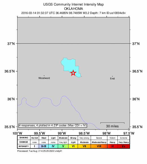
4 people reported to the USGS what they felt; the strongest reported shaking was IV, light shaking.
Fault motion and ground failure
How the rock slipped, from the moment tensor, and the USGS estimate of landslides and liquefaction.
- Faulting
- Strike-slip
- Moment magnitude
- 3.2 Mwr
- Nodal plane 1
- Strike 50°, dip 90°, rake -165°
- Nodal plane 2
- Strike 320°, dip 75°, rake 0°
How well it is located
Reviewed by a seismologist.
- Location uncertainty
- About 2.8 km horizontally, 3.5 km in depth
- Station coverage gap
- 72°
- Stations used
- 0
Nearest places
Distance and direction from each place to the epicenter, with its forecast.
Nearby
Within 100 km, magnitude 1.5 and up: 200 in the 60 days after this one and 0 in the 30 days before it.
After
- 2.018 km SSE of Waynoka, Oklahoma · 3839 days ago · 6 km deep · 4 km away
- 2.58 km W of Mutual, Oklahoma · 3839 days ago · 4 km deep · 53 km away
- 2.511 km NE of Wakita, Oklahoma · 3839 days ago · 4 km deep · 98 km away
- 2.017 km SW of Dacoma, Oklahoma · 3838 days ago · 4 km deep · 10 km away
- 2.817 km SE of Waynoka, Oklahoma · 3838 days ago · 7 km deep · 2 km away
- 3.26 km NW of Dacoma, Oklahoma · 3838 days ago · 7 km deep · 28 km away · felt by 1
- 3.06 km S of Anthony, Kansas · 3838 days ago · 6 km deep · 95 km away · felt by 2
- 2.56 km S of Byron, Oklahoma · 3838 days ago · 3 km deep · 59 km away
- 2.214 km SSW of Dacoma, Oklahoma · 3838 days ago · 6 km deep · 12 km away
- 2.617 km ESE of Waynoka, Oklahoma · 3838 days ago · 5 km deep · 7 km away · felt by 1
- 3.17 km WSW of Aline, Oklahoma · 3838 days ago · 6 km deep · 20 km away · felt by 2
- 1.917 km SSE of Waynoka, Oklahoma · 3838 days ago · 6 km deep · 3 km away
- 2.114 km W of Aline, Oklahoma · 3837 days ago · 5 km deep · 13 km away
- 1.717 km SE of Waynoka, Oklahoma · 3837 days ago · 6 km deep · 3 km away
- 2.117 km SE of Waynoka, Oklahoma · 3837 days ago · 4 km deep · 0 km away
- 1.517 km SSE of Waynoka, Oklahoma · 3837 days ago · 5 km deep · 4 km away
- 2.49 km NE of Quinlan, Oklahoma · 3837 days ago · 5 km deep · 21 km away
- 2.018 km SSE of Waynoka, Oklahoma · 3837 days ago · 5 km deep · 5 km away
- 1.517 km SSE of Waynoka, Oklahoma · 3837 days ago · 5 km deep · 4 km away
- 2.54 km NNW of Douglas, Oklahoma · 3837 days ago · 5 km deep · 97 km away
- 1.717 km SE of Waynoka, Oklahoma · 3837 days ago · 6 km deep · 1 km away
- 1.618 km SSE of Waynoka, Oklahoma · 3836 days ago · 5 km deep · 5 km away
- 2.618 km SSE of Waynoka, Oklahoma · 3836 days ago · 5 km deep · 4 km away
- 3.13 km S of Cleo Springs, Oklahoma · 3836 days ago · 7 km deep · 29 km away · felt by 1
- 3.02 km E of Byron, Oklahoma · 3836 days ago · 5 km deep · 64 km away · felt by 1
- 2.316 km SE of Waynoka, Oklahoma · 3835 days ago · 6 km deep · 1 km away
- 1.813 km SSE of Waynoka, Oklahoma · 3835 days ago · 7 km deep · 5 km away
- 1.612 km SSE of Waynoka, Oklahoma · 3835 days ago · 6 km deep · 5 km away
- 3.15 km SW of Byron, Oklahoma · 3835 days ago · 6 km deep · 57 km away
- 2.717 km SE of Waynoka, Oklahoma · 3834 days ago · 7 km deep · 1 km away
- 2.75 km ENE of Avard, Oklahoma · 3834 days ago · 4 km deep · 29 km away
- 1.718 km SSE of Waynoka, Oklahoma · 3834 days ago · 5 km deep · 4 km away
- 2.85 km NNE of Avard, Oklahoma · 3834 days ago · 4 km deep · 30 km away
- 1.516 km SE of Waynoka, Oklahoma · 3834 days ago · 3 km deep · 1 km away
- 3.09 km NE of Quinlan, Oklahoma · 3834 days ago · 5 km deep · 21 km away · felt by 1
- 2.83 km N of Lambert, Oklahoma · 3833 days ago · 2 km deep · 39 km away · felt by 1
- 2.317 km SE of Waynoka, Oklahoma · 3833 days ago · 5 km deep · 1 km away
- 2.017 km SE of Waynoka, Oklahoma · 3832 days ago · 6 km deep · 2 km away
- 1.817 km SSE of Waynoka, Oklahoma · 3832 days ago · 5 km deep · 3 km away
- 2.917 km SSE of Waynoka, Oklahoma · 3832 days ago · 7 km deep · 3 km away
- 1.517 km SSE of Waynoka, Oklahoma · 3832 days ago · 4 km deep · 3 km away
- 1.616 km SE of Waynoka, Oklahoma · 3832 days ago · 8 km deep · 0 km away
- 2.810 km NW of Medford, Oklahoma · 3832 days ago · 5 km deep · 96 km away · felt by 1
- 2.68 km NE of Quinlan, Oklahoma · 3832 days ago · 4 km deep · 22 km away
- 3.07 km W of Wakita, Oklahoma · 3831 days ago · 5 km deep · 80 km away · felt by 2
- 1.98 km SSE of Anthony, Kansas · 3831 days ago · 6 km deep · 96 km away
- 1.917 km SE of Waynoka, Oklahoma · 3831 days ago · 6 km deep · 1 km away
- 2.017 km SE of Waynoka, Oklahoma · 3831 days ago · 5 km deep · 1 km away
- 2.617 km SE of Waynoka, Oklahoma · 3831 days ago · 7 km deep · 0 km away
- 1.616 km SE of Waynoka, Oklahoma · 3831 days ago · 7 km deep · 1 km away
- 2.717 km SE of Waynoka, Oklahoma · 3831 days ago · 7 km deep · 1 km away
- 1.517 km SE of Waynoka, Oklahoma · 3831 days ago · 5 km deep · 0 km away
- 1.917 km SE of Waynoka, Oklahoma · 3831 days ago · 5 km deep · 1 km away
- 3.35 km N of Kremlin, Oklahoma · 3831 days ago · 7 km deep · 83 km away · felt by 5
- 3.35 km N of Kremlin, Oklahoma · 3831 days ago · 7 km deep · 83 km away
- 1.917 km SSE of Waynoka, Oklahoma · 3831 days ago · 5 km deep · 3 km away
- 1.5Oklahoma · 3831 days ago · 5 km deep · 3 km away
- 1.517 km SE of Waynoka, Oklahoma · 3831 days ago · 5 km deep · 1 km away
- 3.27 km NNW of Hunter, Oklahoma · 3830 days ago · 7 km deep · 96 km away · felt by 3
- 2.55 km ENE of Lambert, Oklahoma · 3830 days ago · 6 km deep · 43 km away
The first 60 of 200.
Earthquakes todayOklahoma earthquakesLive radar here
Sources
From the USGS Earthquake Hazards Program and its partner networks, event us10004x9v. Read Tue, Sep 22, 2026, 12:26 AM UTC.