M3.5 earthquake 3 km ENE of Hunter, Oklahoma
A magnitude 3.5 earthquake struck 3 km ENE of Hunter, Oklahoma on Thu, May 8, 2014, 3:40 PM CDT (20:40 UTC), 5 km (3 mi) below the surface.
A larger quake followed: M3.6 9 km W of Jefferson, Oklahoma. This one was a foreshock.
Map
Where this earthquake was located, with the others nearby. Select one for its page.
The earthquake
- Magnitude
- 3.5 (mwr), minor
- Local time
- UTC
- 2014-05-08 20:40:32 UTC
- Depth
- 5.0 km (3.1 mi), shallow
- Epicenter
- 36.577° N, 97.627° W
- Region
- Oklahoma
- Strongest shaking
- IV, light shaking
- Tsunami flag
- No
- Status
- Reviewed by a seismologist
Shaking
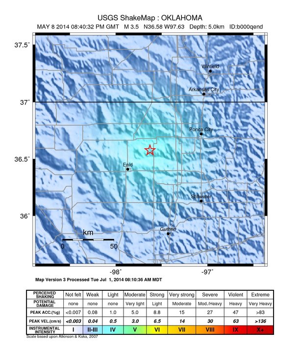
The USGS ShakeMap: shaking estimated from seismic stations and the quake’s size, on the Modified Mercalli intensity scale.
- Strongest estimated
- IV, light shaking
- Map
- Automatic
Did you feel it?
No one has reported feeling this quake to the USGS.
Fault motion and ground failure
How the rock slipped, from the moment tensor, and the USGS estimate of landslides and liquefaction.
- Faulting
- Strike-slip
- Moment magnitude
- 3.5 Mwr
- Nodal plane 1
- Strike 10°, dip 90°, rake -20°
- Nodal plane 2
- Strike 100°, dip 70°, rake -180°
How well it is located
Reviewed by a seismologist.
- Depth from
- OPERATOR_ASSIGNED
- Stations used
- 0
Nearest places
Distance and direction from each place to the epicenter, with its forecast.
Nearby
Within 100 km, magnitude 1.5 and up: 200 in the 60 days after this one and 0 in the 30 days before it.
After
- 2.03 km W of Freeport, Kansas · 4497 days ago · 4 km deep · 73 km away
- 2.56 km ESE of Wakita, Oklahoma · 4496 days ago · 5 km deep · 38 km away
- 3.28 km NNE of Edmond, Oklahoma · 4495 days ago · 5 km deep · 97 km away · felt by 9
- 3.18 km NNE of Edmond, Oklahoma · 4495 days ago · 5 km deep · 97 km away · felt by 6
- 2.77 km NW of Meridian, Oklahoma · 4495 days ago · 5 km deep · 82 km away
- 2.89 km NW of Arcadia, Oklahoma · 4495 days ago · 3 km deep · 96 km away
- 2.68 km NW of Carney, Oklahoma · 4495 days ago · 5 km deep · 93 km away
- 1.84 km W of Freeport, Kansas · 4495 days ago · 6 km deep · 73 km away
- 2.91 km SE of Marshall, Oklahoma · 4495 days ago · 5 km deep · 48 km away
- 2.610 km NW of Arcadia, Oklahoma · 4494 days ago · 5 km deep · 97 km away
- 2.58 km SSW of Perry, Oklahoma · 4494 days ago · 5 km deep · 47 km away
- 2.33 km SSW of Stillwater, Oklahoma · 4493 days ago · 4 km deep · 74 km away · felt by 3
- 2.53 km SSE of Pawnee, Oklahoma · 4492 days ago · 5 km deep · 80 km away · felt by 4
- 2.610 km NW of Arcadia, Oklahoma · 4492 days ago · 4 km deep · 96 km away
- 2.65 km NNW of Mulhall, Oklahoma · 4492 days ago · 2 km deep · 55 km away
- 2.75 km NNW of Mulhall, Oklahoma · 4492 days ago · 3 km deep · 55 km away
- 2.610 km NW of Red Rock, Oklahoma · 4491 days ago · 2 km deep · 33 km away
- 2.68 km NNE of Nardin, Oklahoma · 4491 days ago · 6 km deep · 38 km away
- 2.38 km NNE of Edmond, Oklahoma · 4490 days ago · 6 km deep · 97 km away
- 2.86 km N of Kremlin, Oklahoma · 4490 days ago · 6 km deep · 19 km away · felt by 4
- 2.66 km N of Kremlin, Oklahoma · 4489 days ago · 5 km deep · 18 km away
- 2.38 km SW of Anthony, Kansas · 4489 days ago · 5 km deep · 70 km away
- 2.68 km NNE of Ripley, Oklahoma · 4489 days ago · 5 km deep · 88 km away
- 2.57 km SW of Braman, Oklahoma · 4488 days ago · 6 km deep · 39 km away
- 2.58 km NNE of Nardin, Oklahoma · 4488 days ago · 6 km deep · 38 km away
- 2.79 km NNW of Caldwell, Kansas · 4488 days ago · 6 km deep · 60 km away
- 1.76 km SSE of Anthony, Kansas · 4488 days ago · 5 km deep · 67 km away
- 2.26 km SSE of Anthony, Kansas · 4488 days ago · 6 km deep · 67 km away
- 3.18 km NNE of Edmond, Oklahoma · 4488 days ago · 5 km deep · 97 km away · felt by 33
- 2.70 km E of Quay, Oklahoma · 4488 days ago · 8 km deep · 95 km away
- 3.18 km NNE of Edmond, Oklahoma · 4488 days ago · 5 km deep · 97 km away · felt by 7
- 2.78 km NNE of Edmond, Oklahoma · 4488 days ago · 5 km deep · 97 km away · felt by 3
- 2.08 km NE of Edmond, Oklahoma · 4487 days ago · 5 km deep · 97 km away
- 2.62 km SSE of Pawnee, Oklahoma · 4487 days ago · 5 km deep · 80 km away
- 3.00 km NE of Renfrow, Oklahoma · 4487 days ago · 9 km deep · 39 km away
- 2.53 km NNE of Nash, Oklahoma · 4487 days ago · 3 km deep · 39 km away
- 2.76 km NE of Carmen, Oklahoma · 4487 days ago · 5 km deep · 71 km away
- 2.75 km ESE of Morrison, Oklahoma · 4486 days ago · 6 km deep · 68 km away
- 2.49 km NNW of Caldwell, Kansas · 4485 days ago · 6 km deep · 60 km away
- 2.37 km NNE of Edmond, Oklahoma · 4485 days ago · 5 km deep · 98 km away · felt by 4
- 2.512 km SE of Cedar Valley, Oklahoma · 4485 days ago · 7 km deep · 90 km away
- 2.75 km ENE of Coyle, Oklahoma · 4484 days ago · 5 km deep · 78 km away
- 2.55 km W of Cherokee, Oklahoma · 4483 days ago · 2 km deep · 73 km away
- 3.35 km NE of Hunter, Oklahoma · 4483 days ago · 5 km deep · 3 km away
- 3.06 km ESE of Wakita, Oklahoma · 4483 days ago · 5 km deep · 38 km away
- 3.08 km ENE of Medford, Oklahoma · 4483 days ago · 2 km deep · 28 km away · felt by 5
- 2.811 km SSE of Marshall, Oklahoma · 4483 days ago · 5 km deep · 57 km away
- 2.69 km ESE of Jefferson, Oklahoma · 4481 days ago · 5 km deep · 14 km away
- 2.52 km NW of Mulhall, Oklahoma · 4480 days ago · 6 km deep · 58 km away
- 2.610 km W of Jefferson, Oklahoma · 4480 days ago · 1 km deep · 30 km away
- 2.55 km E of Red Rock, Oklahoma · 4480 days ago · 3 km deep · 47 km away
- 2.28 km NNE of Edmond, Oklahoma · 4480 days ago · 6 km deep · 97 km away
- 3.45 km ENE of Coyle, Oklahoma · 4480 days ago · 6 km deep · 78 km away
- 2.64 km SSE of Orlando, Oklahoma · 4480 days ago · 5 km deep · 57 km away
- 3.25 km ENE of Coyle, Oklahoma · 4480 days ago · 6 km deep · 78 km away · felt by 6
- 3.15 km ENE of Coyle, Oklahoma · 4480 days ago · 5 km deep · 78 km away
- 2.65 km ENE of Coyle, Oklahoma · 4480 days ago · 5 km deep · 78 km away
- 2.55 km ENE of Coyle, Oklahoma · 4480 days ago · 5 km deep · 78 km away
- 3.09 km W of Jefferson, Oklahoma · 4480 days ago · 4 km deep · 29 km away
- 2.610 km W of Jefferson, Oklahoma · 4480 days ago · 5 km deep · 30 km away
The first 60 of 200.
Earthquakes todayOklahoma earthquakesLive radar here
Sources
From the USGS Earthquake Hazards Program and its partner networks, event usb000qend. Read Wed, Sep 23, 2026, 5:40 AM UTC.