M2.8 earthquake 7 km NNE of Glencoe, Oklahoma
A magnitude 2.8 earthquake struck 7 km NNE of Glencoe, Oklahoma on Sat, Sep 21, 2013, 11:36 PM CDT (04:36 UTC), 6 km (4 mi) below the surface.
A larger quake followed: M3.2 7 km N of Spencer, Oklahoma. This one was a foreshock.
Map
Where this earthquake was located, with the others nearby. Select one for its page.
The earthquake
- Magnitude
- 2.8 (ml), micro
- Local time
- UTC
- 2013-09-22 04:36:40 UTC
- Depth
- 6.1 km (3.8 mi), shallow
- Epicenter
- 36.292° N, 96.902° W
- Region
- Oklahoma
- Felt reports
- 4
- Tsunami flag
- No
- Status
- Reviewed by a seismologist
Did you feel it?
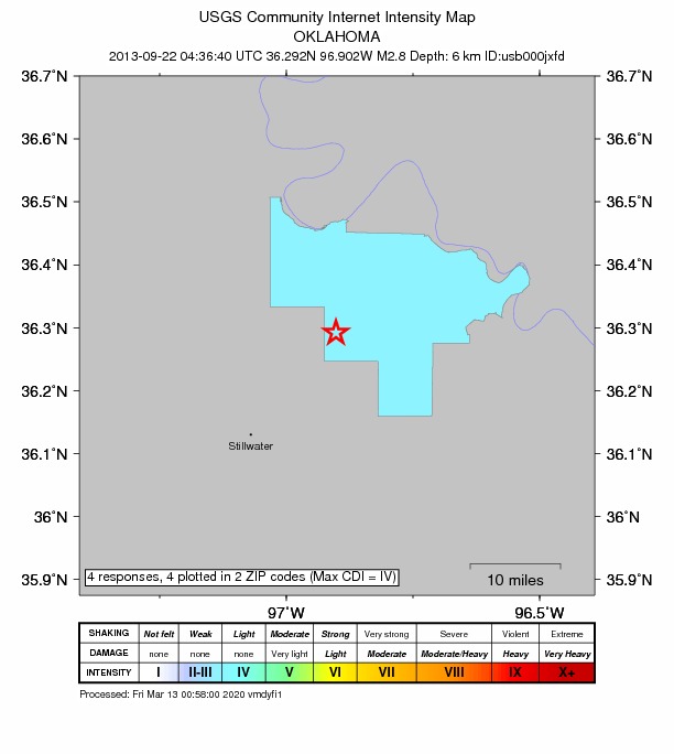
4 people reported to the USGS what they felt; the strongest reported shaking was IV, light shaking.
How well it is located
Reviewed by a seismologist.
- Stations used
- 0
Nearest places
Distance and direction from each place to the epicenter, with its forecast.
Nearby
Within 100 km, magnitude 1.5 and up: 83 in the 60 days after this one and 4 in the 30 days before it.
After
- 3.27 km N of Spencer, Oklahoma · 4744 days ago · 6 km deep · 89 km away · felt by 19
- 2.97 km N of Spencer, Oklahoma · 4739 days ago · 6 km deep · 89 km away · felt by 13
- 2.57 km N of Spencer, Oklahoma · 4739 days ago · 6 km deep · 89 km away
- 3.24 km N of Kremlin, Oklahoma · 4739 days ago · 5 km deep · 90 km away · felt by 11
- 3.15 km N of Kremlin, Oklahoma · 4738 days ago · 5 km deep · 90 km away
- 3.55 km N of Kremlin, Oklahoma · 4738 days ago · 4 km deep · 90 km away · felt by 18
- 2.87 km N of Spencer, Oklahoma · 4738 days ago · 5 km deep · 89 km away · felt by 6
- 2.91 km WNW of Spencer, Oklahoma · 4737 days ago · 5 km deep · 96 km away · felt by 21
- 2.94 km NNE of Kremlin, Oklahoma · 4735 days ago · 5 km deep · 88 km away · felt by 3
- 3.33 km NNE of Kremlin, Oklahoma · 4735 days ago · 5 km deep · 88 km away
- 2.910 km ESE of Glencoe, Oklahoma · 4731 days ago · 2 km deep · 14 km away · felt by 9
- 2.710 km WNW of Quay, Oklahoma · 4731 days ago · 5 km deep · 14 km away
- 2.53 km NNE of Kremlin, Oklahoma · 4731 days ago · 6 km deep · 87 km away
- 2.10 km N of Prague, Oklahoma · 4729 days ago · 4 km deep · 91 km away
- 2.28 km NNE of Edmond, Oklahoma · 4729 days ago · 4 km deep · 80 km away
- 2.53 km NNE of Kremlin, Oklahoma · 4728 days ago · 6 km deep · 88 km away
- 2.75 km NNE of Kremlin, Oklahoma · 4728 days ago · 5 km deep · 89 km away
- 2.76 km N of Kremlin, Oklahoma · 4725 days ago · 5 km deep · 89 km away
- 2.95 km E of Luther, Oklahoma · 4722 days ago · 5 km deep · 72 km away
- 2.58 km N of Spencer, Oklahoma · 4722 days ago · 5 km deep · 88 km away
- 3.13 km SW of Pond Creek, Oklahoma · 4720 days ago · 5 km deep · 92 km away
- 2.88 km SSW of Arcadia, Oklahoma · 4720 days ago · 3 km deep · 87 km away
- 2.88 km ESE of Douglas, Oklahoma · 4717 days ago · 5 km deep · 62 km away
- 2.43 km NNE of Medford, Oklahoma · 4716 days ago · 3 km deep · 94 km away
- 3.05 km SW of Kremlin, Oklahoma · 4714 days ago · 5 km deep · 91 km away · felt by 7
- 2.54 km NNW of Quay, Oklahoma · 4713 days ago · 5 km deep · 19 km away
- 2.78 km SSW of Arcadia, Oklahoma · 4710 days ago · 4 km deep · 88 km away
- 2.68 km N of Spencer, Oklahoma · 4710 days ago · 5 km deep · 88 km away · felt by 3
- 2.22 km SW of Stillwater, Oklahoma · 4709 days ago · 5 km deep · 27 km away
- 3.58 km WNW of Jones, Oklahoma · 4707 days ago · 5 km deep · 88 km away · felt by 153
- 2.98 km N of Spencer, Oklahoma · 4707 days ago · 5 km deep · 88 km away · felt by 10
- 2.88 km N of Spencer, Oklahoma · 4707 days ago · 5 km deep · 88 km away · felt by 3
- 3.28 km N of Spencer, Oklahoma · 4707 days ago · 6 km deep · 88 km away · felt by 26
- 3.46 km SSW of Arcadia, Oklahoma · 4707 days ago · 5 km deep · 86 km away · felt by 109
- 2.78 km NE of Lake Aluma, Oklahoma · 4707 days ago · 5 km deep · 89 km away · felt by 4
- 3.07 km NE of Lake Aluma, Oklahoma · 4707 days ago · 5 km deep · 89 km away · felt by 15
- 2.68 km N of Spencer, Oklahoma · 4707 days ago · 6 km deep · 88 km away · felt by 6
- 2.58 km SW of Arcadia, Oklahoma · 4706 days ago · 4 km deep · 87 km away · felt by 9
- 3.38 km NE of Lake Aluma, Oklahoma · 4705 days ago · 6 km deep · 89 km away · felt by 88
- 2.58 km SW of Arcadia, Oklahoma · 4705 days ago · 5 km deep · 88 km away · felt by 4
- 2.41 km NW of Quay, Oklahoma · 4705 days ago · 5 km deep · 21 km away
- 2.08 km NNE of Lake Aluma, Oklahoma · 4705 days ago · 5 km deep · 88 km away
- 3.88 km SSW of Arcadia, Oklahoma · 4704 days ago · 5 km deep · 87 km away · felt by 339
- 2.58 km SW of Arcadia, Oklahoma · 4704 days ago · 4 km deep · 88 km away
- 3.25 km NNE of Lake Aluma, Oklahoma · 4704 days ago · 5 km deep · 91 km away · felt by 38
- 2.18 km N of Spencer, Oklahoma · 4701 days ago · 4 km deep · 88 km away · felt by 3
- 2.67 km N of Spencer, Oklahoma · 4701 days ago · 5 km deep · 88 km away
- 3.37 km N of Spencer, Oklahoma · 4701 days ago · 5 km deep · 89 km away · felt by 71
- 3.37 km N of Spencer, Oklahoma · 4701 days ago · 5 km deep · 89 km away
- 2.47 km SSW of Arcadia, Oklahoma · 4701 days ago · 5 km deep · 87 km away · felt by 3
- 2.68 km N of Spencer, Oklahoma · 4701 days ago · 5 km deep · 88 km away · felt by 6
- 2.22 km NNW of Prague, Oklahoma · 4699 days ago · 5 km deep · 89 km away
- 2.38 km WNW of Jones, Oklahoma · 4699 days ago · 5 km deep · 88 km away
- 2.53 km SSE of Jones, Oklahoma · 4699 days ago · 6 km deep · 90 km away · felt by 2
- 3.58 km NNE of Edmond, Oklahoma · 4698 days ago · 5 km deep · 79 km away · felt by 118
- 2.38 km NNE of Edmond, Oklahoma · 4698 days ago · 5 km deep · 79 km away · felt by 5
- 2.18 km NNE of Lake Aluma, Oklahoma · 4698 days ago · 7 km deep · 88 km away
- 1.98 km NNE of Edmond, Oklahoma · 4698 days ago · 6 km deep · 80 km away · felt by 6
- 1.98 km NNE of Edmond, Oklahoma · 4698 days ago · 4 km deep · 79 km away
- 2.35 km NE of Edmond, Oklahoma · 4698 days ago · 5 km deep · 82 km away
The first 60 of 83.
Before
Earthquakes todayOklahoma earthquakesLive radar here
Sources
From the USGS Earthquake Hazards Program and its partner networks, event usb000jxfd. Read Tue, Sep 22, 2026, 10:00 AM UTC.