M3.5 earthquake 5 km ESE of Meeker, Oklahoma
A magnitude 3.5 earthquake struck 5 km ESE of Meeker, Oklahoma on Sun, Nov 6, 2011, 3:22 AM CST (09:22 UTC), 5 km (3 mi) below the surface.
A larger quake followed: M3.7 5 km SE of Meeker, Oklahoma. This one was a foreshock.
Map
Where this earthquake was located, with the others nearby. Select one for its page.
The earthquake
- Magnitude
- 3.5 (ml), minor
- Local time
- UTC
- 2011-11-06 09:22:04 UTC
- Depth
- 5.0 km (3.1 mi), shallow
- Epicenter
- 35.485° N, 96.844° W
- Region
- Oklahoma
- Felt reports
- 15
- Tsunami flag
- No
- Status
- Reviewed by a seismologist
Did you feel it?
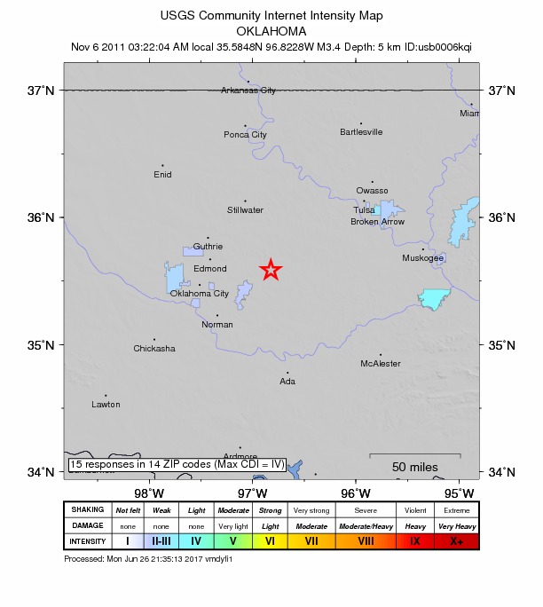
15 people reported to the USGS what they felt; the strongest reported shaking was IV, light shaking.
How well it is located
Reviewed by a seismologist.
- Station coverage gap
- 35°
- Stations used
- 38
Nearest places
Distance and direction from each place to the epicenter, with its forecast.
Nearby
Within 100 km, magnitude 1.5 and up: 68 in the 60 days after this one and 27 in the 30 days before it.
After
- 3.75 km SE of Meeker, Oklahoma · 5434 days ago · 5 km deep · 3 km away · felt by 224
- 3.68 km SSE of Sparks, Oklahoma · 5434 days ago · 3 km deep · 8 km away · felt by 268
- 3.15 km E of Meeker, Oklahoma · 5434 days ago · 5 km deep · 1 km away · felt by 57
- 2.87 km ENE of Meeker, Oklahoma · 5434 days ago · 5 km deep · 5 km away · felt by 31
- 2.93 km ESE of Meeker, Oklahoma · 5434 days ago · 5 km deep · 2 km away · felt by 210
- 3.84 km ESE of Meeker, Oklahoma · 5434 days ago · 5 km deep · 1 km away · felt by 640
- 2.98 km WNW of Prague, Oklahoma · 5434 days ago · 3 km deep · 8 km away
- 3.46 km E of Meeker, Oklahoma · 5434 days ago · 3 km deep · 2 km away · felt by 174
- 3.14 km SE of Meeker, Oklahoma · 5434 days ago · 3 km deep · 3 km away · felt by 184
- 2.99 km SE of Sparks, Oklahoma · 5433 days ago · 5 km deep · 11 km away
- 2.98 km E of Meeker, Oklahoma · 5433 days ago · 3 km deep · 4 km away · felt by 52
- 3.09 km WNW of Prague, Oklahoma · 5433 days ago · 4 km deep · 7 km away · felt by 42
- 3.39 km WNW of Prague, Oklahoma · 5433 days ago · 3 km deep · 6 km away · felt by 212
- 3.17 km NW of Prague, Oklahoma · 5433 days ago · 5 km deep · 10 km away
- 2.59 km E of Meeker, Oklahoma · 5433 days ago · 5 km deep · 5 km away
- 3.19 km WNW of Prague, Oklahoma · 5433 days ago · 3 km deep · 6 km away
- 3.15 km SE of Meeker, Oklahoma · 5433 days ago · 3 km deep · 1 km away · felt by 251
- 3.29 km E of Meeker, Oklahoma · 5433 days ago · 5 km deep · 5 km away
- 4.89 km SSE of Sparks, Oklahoma · 5432 days ago · 5 km deep · 7 km away · felt by 16,034
- 3.19 km WNW of Prague, Oklahoma · 5432 days ago · 5 km deep · 7 km away
- 3.58 km WNW of Prague, Oklahoma · 5432 days ago · 3 km deep · 8 km away · felt by 459
- 3.48 km NW of Prague, Oklahoma · 5431 days ago · 5 km deep · 9 km away · felt by 134
- 3.01 km SW of Spencer, Oklahoma · 5431 days ago · 3 km deep · 50 km away
- 2.99 km WNW of Prague, Oklahoma · 5431 days ago · 3 km deep · 7 km away
- 3.25 km ESE of Meeker, Oklahoma · 5430 days ago · 3 km deep · 1 km away · felt by 102
- 3.28 km NW of Prague, Oklahoma · 5429 days ago · 4 km deep · 10 km away
- 3.17 km NNW of Prague, Oklahoma · 5428 days ago · 4 km deep · 12 km away · felt by 47
- 3.27 km NW of Prague, Oklahoma · 5428 days ago · 6 km deep · 10 km away
- 1.63 km W of Sparks, Oklahoma · 5428 days ago · 5 km deep · 13 km away
- 2.55 km SE of Meeker, Oklahoma · 5427 days ago · 3 km deep · 3 km away · felt by 8
- 3.25 km SSE of Meeker, Oklahoma · 5427 days ago · 5 km deep · 4 km away · felt by 77
- 2.94 km SSE of Meeker, Oklahoma · 5427 days ago · 5 km deep · 4 km away
- 3.29 km WNW of Prague, Oklahoma · 5426 days ago · 3 km deep · 7 km away · felt by 75
- 2.58 km NW of Prague, Oklahoma · 5426 days ago · 3 km deep · 11 km away
- 2.44 km SE of Meeker, Oklahoma · 5425 days ago · 5 km deep · 2 km away · felt by 22
- 2.29 km WNW of Prague, Oklahoma · 5425 days ago · 5 km deep · 7 km away
- 2.89 km WNW of Prague, Oklahoma · 5424 days ago · 5 km deep · 7 km away · felt by 50
- 2.79 km WNW of Prague, Oklahoma · 5424 days ago · 5 km deep · 7 km away
- 3.29 km E of Meeker, Oklahoma · 5424 days ago · 5 km deep · 4 km away · felt by 18
- 2.80 km W of Jones, Oklahoma · 5422 days ago · 4 km deep · 42 km away · felt by 23
- 3.39 km SE of Sparks, Oklahoma · 5422 days ago · 7 km deep · 10 km away · felt by 37
- 2.88 km NW of Prague, Oklahoma · 5420 days ago · 4 km deep · 12 km away · felt by 30
- 2.64 km S of Luther, Oklahoma · 5420 days ago · 2 km deep · 35 km away
- 2.84 km WSW of Fallis, Oklahoma · 5419 days ago · 3 km deep · 40 km away · felt by 29
- 3.08 km E of Meeker, Oklahoma · 5418 days ago · 5 km deep · 4 km away · felt by 31
- 3.45 km SSE of Sparks, Oklahoma · 5415 days ago · 6 km deep · 10 km away · felt by 362
- 2.54 km SSE of Meeker, Oklahoma · 5415 days ago · 5 km deep · 5 km away
- 3.45 km SSE of Meeker, Oklahoma · 5415 days ago · 0 km deep · 4 km away · felt by 43
- 3.46 km WNW of Prague, Oklahoma · 5414 days ago · 4 km deep · 9 km away · felt by 50
- 2.47 km WNW of Prague, Oklahoma · 5414 days ago · 5 km deep · 8 km away · felt by 17
- 3.14 km WSW of Fallis, Oklahoma · 5413 days ago · 5 km deep · 40 km away · felt by 61
- 2.78 km NW of Prague, Oklahoma · 5411 days ago · 4 km deep · 10 km away · felt by 44
- 2.73 km SW of Arpelar, Oklahoma · 5411 days ago · 0 km deep · 99 km away
- 2.77 km NE of McLoud, Oklahoma · 5409 days ago · 5 km deep · 17 km away · felt by 4
- 3.38 km WNW of Prague, Oklahoma · 5407 days ago · 9 km deep · 8 km away · felt by 27
- 2.39 km WNW of Prague, Oklahoma · 5407 days ago · 5 km deep · 7 km away · felt by 13
- 2.35 km WSW of Fallis, Oklahoma · 5406 days ago · 5 km deep · 40 km away · felt by 13
- 3.05 km SE of Meeker, Oklahoma · 5401 days ago · 5 km deep · 1 km away · felt by 7
- 2.57 km NW of Prague, Oklahoma · 5398 days ago · 4 km deep · 10 km away
- 2.50 km SSE of Choctaw, Oklahoma · 5397 days ago · 1 km deep · 38 km away · felt by 15
The first 60 of 68.
Before
- 3.18 km WNW of Prague, Oklahoma · 5434 days ago · 6 km deep · 8 km away · felt by 9
- 3.02 km SSW of Sparks, Oklahoma · 5434 days ago · 5 km deep · 11 km away
- 3.66 km ENE of Meeker, Oklahoma · 5434 days ago · 5 km deep · 4 km away
- 3.25 km ESE of Meeker, Oklahoma · 5434 days ago · 5 km deep · 1 km away · felt by 64
- 3.74 km SE of Meeker, Oklahoma · 5434 days ago · 5 km deep · 2 km away · felt by 167
- 3.38 km NW of Prague, Oklahoma · 5434 days ago · 5 km deep · 11 km away
- 3.99 km WNW of Prague, Oklahoma · 5434 days ago · 5 km deep · 7 km away
- 3.09 km WNW of Prague, Oklahoma · 5434 days ago · 5 km deep · 6 km away
- 4.08 km WNW of Prague, Oklahoma · 5434 days ago · 5 km deep · 8 km away
- 5.78 km NW of Prague, Oklahoma · 5434 days ago · 5 km deep · 9 km away · felt by 59,356
- 3.08 km NW of Prague, Oklahoma · 5434 days ago · 5 km deep · 11 km away
- 3.69 km WNW of Prague, Oklahoma · 5435 days ago · 5 km deep · 7 km away · felt by 261
- 3.28 km WNW of Prague, Oklahoma · 5435 days ago · 5 km deep · 9 km away · felt by 159
- 3.49 km WNW of Prague, Oklahoma · 5435 days ago · 5 km deep · 8 km away · felt by 128
- 3.38 km WNW of Prague, Oklahoma · 5435 days ago · 5 km deep · 9 km away · felt by 162
- 2.68 km NW of Prague, Oklahoma · 5435 days ago · 5 km deep · 10 km away
- 2.67 km SE of Sparks, Oklahoma · 5435 days ago · 5 km deep · 10 km away · felt by 7
- 2.69 km NW of Prague, Oklahoma · 5435 days ago · 5 km deep · 10 km away · felt by 16
- 3.38 km SE of Sparks, Oklahoma · 5435 days ago · 3 km deep · 10 km away · felt by 176
- 4.88 km SE of Sparks, Oklahoma · 5435 days ago · 3 km deep · 10 km away · felt by 10,180
Earthquakes todayOklahoma earthquakesLive radar here
Sources
From the USGS Earthquake Hazards Program and its partner networks, event usp000jaek (also filed as usb0006kqi). Read Tue, Sep 22, 2026, 8:00 AM UTC.