M7.6 earthquake 16 km SSW of Cuyutlán, Mexico
A magnitude 7.6 earthquake struck 16 km SSW of Cuyutlán, Mexico on Tue, Jan 21, 2003, 8:06 PM CST (02:06 UTC), 24 km (15 mi) below the surface.
Map
Where this earthquake was located, with the others nearby. Select one for its page.
The earthquake
- Magnitude
- 7.6 (mwb), major
- Local time
- UTC
- 2003-01-22 02:06:34 UTC
- Depth
- 24.0 km (14.9 mi), shallow
- Epicenter
- 18.770° N, 104.104° W
- Region
- Mexico
- Strongest shaking
- VII, very strong shaking
- Tsunami flag
- No
- Status
- Reviewed by a seismologist
Shaking
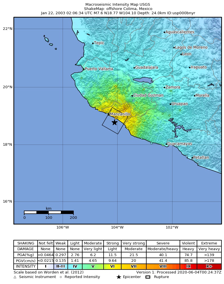
The USGS ShakeMap: shaking estimated from seismic stations and the quake’s size, on the Modified Mercalli intensity scale.
- Strongest estimated
- VII, very strong shaking
- Peak ground acceleration
- 27.5% of gravity
- Peak ground velocity
- 3.4 cm/s
- Map
- Automatic
Did you feel it?
No one has reported feeling this quake to the USGS.
Fault motion and ground failure
How the rock slipped, from the moment tensor, and the USGS estimate of landslides and liquefaction.
- Faulting
- Reverse (thrust)
- Moment magnitude
- 7.4 Mww
- Nodal plane 1
- Strike 292°, dip 20°, rake 78°
- Nodal plane 2
- Strike 124°, dip 69°, rake 94°
- Landslide alert
- Orange
- Liquefaction alert
- Orange
How well it is located
Reviewed by a seismologist.
- Depth from
- OPERATOR_ASSIGNED
- Stations used
- 551
Nearest places
Distance and direction from each place to the epicenter, with its forecast.
Nearby
Within 100 km, magnitude 2.5 and up: 52 in the 60 days after this one and 0 in the 30 days before it.
After
- 4.757 km SSW of Cuyutlán, Mexico · 8645 days ago · 10 km deep · 42 km away
- 5.174 km SW of Cuyutlán, Mexico · 8645 days ago · 10 km deep · 60 km away
- 4.066 km SW of Cuyutlán, Mexico · 8644 days ago · 10 km deep · 53 km away
- 4.053 km SSW of Cuyutlán, Mexico · 8644 days ago · 10 km deep · 37 km away
- 4.047 km SSW of Cuyutlán, Mexico · 8644 days ago · 10 km deep · 31 km away
- 3.857 km SSW of Cuyutlán, Mexico · 8644 days ago · 10 km deep · 41 km away
- 4.323 km SSW of Cuyutlán, Mexico · 8644 days ago · 10 km deep · 9 km away
- 4.254 km SSW of Cuyutlán, Mexico · 8644 days ago · 10 km deep · 39 km away
- 4.324 km SSW of Cuyutlán, Mexico · 8644 days ago · 10 km deep · 9 km away
- 3.94 km N of Venustiano Carranza, Mexico · 8644 days ago · 15 km deep · 31 km away
- 3.850 km S of Cuyutlán, Mexico · 8644 days ago · 11 km deep · 34 km away
- 3.945 km SSW of Cuyutlán, Mexico · 8644 days ago · 8 km deep · 29 km away
- 5.929 km SSW of El Colomo, Mexico · 8644 days ago · 10 km deep · 29 km away
- 4.062 km SSW of El Naranjo, Mexico · 8644 days ago · 22 km deep · 61 km away
- 5.542 km SSW of El Colomo, Mexico · 8644 days ago · 10 km deep · 38 km away
- 3.752 km SSW of El Naranjo, Mexico · 8644 days ago · 16 km deep · 53 km away
- 3.549 km SSW of El Naranjo, Mexico · 8644 days ago · 16 km deep · 51 km away
- 3.948 km SSW of El Colomo, Mexico · 8644 days ago · 31 km deep · 43 km away
- 4.036 km SSW of El Naranjo, Mexico · 8644 days ago · 10 km deep · 49 km away
- 3.953 km SSW of El Colomo, Mexico · 8644 days ago · 20 km deep · 44 km away
- 4.131 km SSW of La Central, Mexico · 8643 days ago · 19 km deep · 53 km away
- 4.038 km SSW of El Naranjo, Mexico · 8643 days ago · 13 km deep · 49 km away
- 3.726 km SW of Cerro de Ortega, Mexico · 8643 days ago · 17 km deep · 35 km away
- 4.132 km SSW of Cuyutlán, Mexico · 8643 days ago · 20 km deep · 15 km away
- 4.352 km SW of Cuyutlán, Mexico · 8643 days ago · 10 km deep · 38 km away
- 4.340 km SW of Cuyutlán, Mexico · 8643 days ago · 16 km deep · 27 km away
- 3.956 km SSW of Cuyutlán, Mexico · 8643 days ago · 20 km deep · 41 km away
- 3.828 km SSW of Cuyutlán, Mexico · 8642 days ago · 4 km deep · 12 km away
- 4.050 km SSW of El Naranjo, Mexico · 8642 days ago · 16 km deep · 52 km away
- 3.925 km WSW of Cuyutlán, Mexico · 8642 days ago · 10 km deep · 19 km away
- 3.749 km SW of Cuyutlán, Mexico · 8642 days ago · 16 km deep · 35 km away
- 3.749 km SSW of El Colomo, Mexico · 8642 days ago · 18 km deep · 43 km away
- 4.034 km SW of El Colomo, Mexico · 8640 days ago · 5 km deep · 37 km away
- 3.728 km SSW of Cerro de Ortega, Mexico · 8638 days ago · 33 km deep · 36 km away
- 3.819 km SSE of Cuyutlán, Mexico · 8637 days ago · 10 km deep · 11 km away
- 4.352 km SSW of Cuyutlán, Mexico · 8632 days ago · 10 km deep · 35 km away
- 3.648 km SSW of Cuyutlán, Mexico · 8631 days ago · 10 km deep · 32 km away
- 3.845 km SW of Cerro de Ortega, Mexico · 8629 days ago · 20 km deep · 31 km away
- 3.81 km S of Comala, Mexico · 8624 days ago · 97 km deep · 71 km away
- 4.146 km SSW of El Colomo, Mexico · 8623 days ago · 16 km deep · 38 km away
- 4.035 km SSW of El Colomo, Mexico · 8623 days ago · 7 km deep · 33 km away
- 4.143 km S of Cuyutlán, Mexico · 8621 days ago · 14 km deep · 27 km away
- 5.317 km SW of Barra de Navidad, Mexico · 8618 days ago · 33 km deep · 79 km away
- 4.158 km SSW of El Colomo, Mexico · 8616 days ago · 13 km deep · 49 km away
- 3.84 km WSW of Tecomán, Mexico · 8615 days ago · 5 km deep · 24 km away
- 4.267 km S of Barra de Navidad, Mexico · 8609 days ago · 10 km deep · 71 km away
- 4.361 km SSW of Cuyutlán, Mexico · 8599 days ago · 10 km deep · 45 km away
- 4.3Near the coast of Colima, Mexico · 8596 days ago · 10 km deep · 40 km away
- 4.014 km SSW of Manzanillo, Mexico · 8596 days ago · 10 km deep · 38 km away
- 3.949 km SSW of El Naranjo, Mexico · 8592 days ago · 16 km deep · 48 km away
- 3.954 km SSW of El Naranjo, Mexico · 8592 days ago · 16 km deep · 49 km away
- 4.057 km SW of Cuyutlán, Mexico · 8586 days ago · 18 km deep · 45 km away
Earthquakes todayMexico earthquakesLive radar here
Sources
From the USGS Earthquake Hazards Program and its partner networks, event usp000bnyr (also filed as choy20030122020634, gcmtc012203a, duputel012203a, gcmt20030122020634, atlas20030122020636, iscgem6541364). Read Tue, Sep 22, 2026, 3:11 PM UTC.