M5.4 earthquake 54 km SE of Gilgit, Pakistan
A magnitude 5.4 earthquake struck 54 km SE of Gilgit, Pakistan on Sat, Nov 2, 2002, 3:09 AM GMT+5 (22:09 UTC), 33 km (21 mi) below the surface.
A larger quake followed: M6.3 58 km SSE of Gilgit, Pakistan. This one was a foreshock.
Map
Where this earthquake was located, with the others nearby. Select one for its page.
The earthquake
- Magnitude
- 5.4 (mwc), moderate
- Local time
- UTC
- 2002-11-01 22:09:29 UTC
- Depth
- 33.0 km (20.5 mi), shallow
- Epicenter
- 35.517° N, 74.654° E
- Region
- Pakistan
- Strongest shaking
- V, moderate shaking
- Tsunami flag
- No
- Status
- Reviewed by a seismologist
Shaking
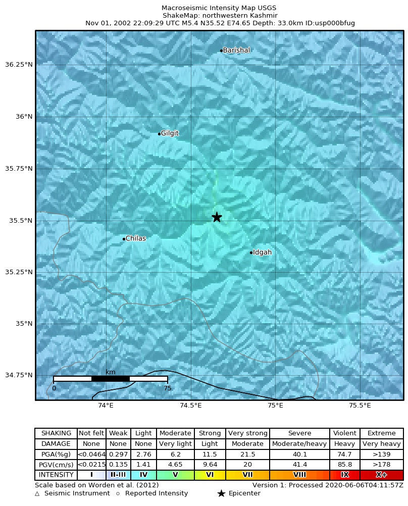
The USGS ShakeMap: shaking estimated from seismic stations and the quake’s size, on the Modified Mercalli intensity scale.
- Strongest estimated
- V, moderate shaking
- Peak ground acceleration
- 6.3% of gravity
- Peak ground velocity
- 1.3 cm/s
- Map
- Automatic
Did you feel it?
No one has reported feeling this quake to the USGS.
Fault motion and ground failure
How the rock slipped, from the moment tensor, and the USGS estimate of landslides and liquefaction.
- Faulting
- Normal
- Nodal plane 1
- Strike 216°, dip 42°, rake -90°
- Nodal plane 2
- Strike 36°, dip 48°, rake -90°
How well it is located
Reviewed by a seismologist.
- Depth from
- OPERATOR_ASSIGNED
- Stations used
- 264
Nearest places
Distance and direction from each place to the epicenter, with its forecast.
Nearby
Within 100 km, magnitude 2.4 and up: 67 in the 60 days after this one and 0 in the 30 days before it.
After
- 4.168 km S of Gilgit, Pakistan · 8725 days ago · 33 km deep · 46 km away
- 4.847 km SSE of Gilgit, Pakistan · 8725 days ago · 33 km deep · 9 km away
- 4.255 km SSE of Gilgit, Pakistan · 8725 days ago · 33 km deep · 10 km away
- 5.231 km SSE of Gilgit, Pakistan · 8725 days ago · 33 km deep · 26 km away
- 4.367 km SSE of Gilgit, Pakistan · 8725 days ago · 33 km deep · 19 km away
- 4.477 km SSE of Gilgit, Pakistan · 8725 days ago · 33 km deep · 29 km away
- 4.475 km S of Gilgit, Pakistan · 8725 days ago · 33 km deep · 36 km away
- 4.455 km SSE of Gilgit, Pakistan · 8724 days ago · 33 km deep · 17 km away
- 3.951 km SSE of Gilgit, Pakistan · 8724 days ago · 33 km deep · 7 km away
- 4.658 km SSE of Gilgit, Pakistan · 8724 days ago · 33 km deep · 13 km away
- 4.751 km SSE of Gilgit, Pakistan · 8724 days ago · 33 km deep · 15 km away
- 4.659 km SSE of Gilgit, Pakistan · 8724 days ago · 33 km deep · 7 km away
- 4.660 km SSE of Gilgit, Pakistan · 8724 days ago · 33 km deep · 16 km away
- 4.660 km SSE of Gilgit, Pakistan · 8724 days ago · 33 km deep · 11 km away
- 3.773 km SSE of Gilgit, Pakistan · 8724 days ago · 33 km deep · 25 km away
- 4.052 km SSE of Gilgit, Pakistan · 8724 days ago · 33 km deep · 3 km away
- 4.671 km SSE of Gilgit, Pakistan · 8724 days ago · 33 km deep · 23 km away
- 4.558 km SSE of Gilgit, Pakistan · 8724 days ago · 33 km deep · 8 km away
- 5.361 km SSE of Gilgit, Pakistan · 8724 days ago · 33 km deep · 12 km away
- 4.784 km SSE of Gilgit, Pakistan · 8723 days ago · 31 km deep · 39 km away
- 3.769 km SSW of Gilgit, Pakistan · 8723 days ago · 33 km deep · 52 km away
- 4.071 km SE of Gilgit, Pakistan · 8723 days ago · 33 km deep · 19 km away
- 4.053 km SE of Gilgit, Pakistan · 8723 days ago · 33 km deep · 1 km away
- 3.663 km WNW of Skardu, Pakistan · 8723 days ago · 33 km deep · 30 km away
- 3.463 km SSE of Gilgit, Pakistan · 8723 days ago · 33 km deep · 10 km away
- 4.465 km SE of Gilgit, Pakistan · 8723 days ago · 33 km deep · 21 km away
- 4.472 km SSE of Gilgit, Pakistan · 8723 days ago · 33 km deep · 18 km away
- 4.764 km SSE of Gilgit, Pakistan · 8723 days ago · 33 km deep · 17 km away
- 3.978 km SSW of Gilgit, Pakistan · 8723 days ago · 33 km deep · 61 km away
- 3.968 km SSW of Gilgit, Pakistan · 8723 days ago · 33 km deep · 54 km away
- 3.378 km S of Gilgit, Pakistan · 8722 days ago · 33 km deep · 48 km away
- 4.553 km SSE of Gilgit, Pakistan · 8722 days ago · 33 km deep · 14 km away
- 4.259 km SE of Gilgit, Pakistan · 8722 days ago · 33 km deep · 10 km away
- 4.852 km SSE of Gilgit, Pakistan · 8722 days ago · 33 km deep · 8 km away
- 4.353 km SSE of Gilgit, Pakistan · 8721 days ago · 33 km deep · 15 km away
- 4.553 km SSE of Gilgit, Pakistan · 8721 days ago · 33 km deep · 12 km away
- 3.767 km SSE of Gilgit, Pakistan · 8719 days ago · 33 km deep · 16 km away
- 4.058 km S of Gilgit, Pakistan · 8719 days ago · 33 km deep · 24 km away
- 4.656 km SSE of Gilgit, Pakistan · 8719 days ago · 33 km deep · 3 km away
- 3.862 km SSW of Gilgit, Pakistan · 8719 days ago · 33 km deep · 47 km away
- 4.751 km SSE of Gilgit, Pakistan · 8719 days ago · 33 km deep · 8 km away
- 4.571 km SE of Gilgit, Pakistan · 8719 days ago · 33 km deep · 18 km away
- 4.052 km SSE of Gilgit, Pakistan · 8718 days ago · 33 km deep · 9 km away
- 3.657 km S of Gilgit, Pakistan · 8708 days ago · 150 km deep · 41 km away
- 6.358 km SSE of Gilgit, Pakistan · 8706 days ago · 33 km deep · 17 km away
- 5.060 km SSE of Gilgit, Pakistan · 8706 days ago · 33 km deep · 15 km away
- 3.955 km SSE of Gilgit, Pakistan · 8706 days ago · 33 km deep · 7 km away
- 4.454 km SSE of Gilgit, Pakistan · 8706 days ago · 33 km deep · 5 km away
- 4.564 km SSE of Gilgit, Pakistan · 8706 days ago · 33 km deep · 17 km away
- 4.062 km SSE of Gilgit, Pakistan · 8706 days ago · 33 km deep · 12 km away
- 4.661 km SSE of Gilgit, Pakistan · 8706 days ago · 33 km deep · 11 km away
- 3.547 km SSE of Gilgit, Pakistan · 8706 days ago · 33 km deep · 7 km away
- 3.8northwestern Kashmir · 8706 days ago · 33 km deep · 21 km away
- 4.445 km SE of Gilgit, Pakistan · 8705 days ago · 33 km deep · 9 km away
- 3.854 km SSE of Gilgit, Pakistan · 8702 days ago · 33 km deep · 10 km away
- 4.777 km SSE of Gilgit, Pakistan · 8702 days ago · 33 km deep · 23 km away
- 4.972 km W of Skardu, Pakistan · 8702 days ago · 33 km deep · 27 km away
- 3.979 km NNE of Muzaffar?b?d, Pakistan · 8702 days ago · 33 km deep · 94 km away
- 4.365 km SSE of Gilgit, Pakistan · 8702 days ago · 33 km deep · 20 km away
- 4.463 km SSE of Gilgit, Pakistan · 8701 days ago · 33 km deep · 19 km away
The first 60 of 67.
Earthquakes todayPakistan earthquakesLive radar here
Sources
From the USGS Earthquake Hazards Program and its partner networks, event usp000bfug (also filed as gcmtb110102g, gcmt20021101220929, iscgem6121584, atlas20021101220929). Read Mon, Sep 21, 2026, 7:14 PM UTC.