M5.1 earthquake 20 km WNW of Klamath Falls, Oregon
A magnitude 5.1 earthquake struck 20 km WNW of Klamath Falls, Oregon on Sat, Dec 4, 1993, 2:15 PM PST (22:15 UTC), 5 km (3 mi) below the surface.
Map
Where this earthquake was located, with the others nearby. Select one for its page.
The earthquake
- Magnitude
- 5.1 (md), moderate
- Local time
- UTC
- 1993-12-04 22:15:19 UTC
- Depth
- 4.8 km (3.0 mi), shallow
- Epicenter
- 42.291° N, 122.009° W
- Region
- Oregon
- Strongest shaking
- VI, strong shaking
- Tsunami flag
- No
- Status
- Reviewed by a seismologist
Shaking
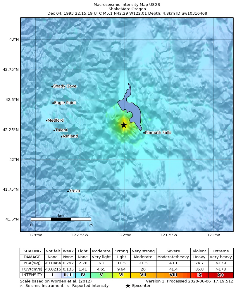
The USGS ShakeMap: shaking estimated from seismic stations and the quake’s size, on the Modified Mercalli intensity scale.
- Strongest estimated
- VI, strong shaking
- Peak ground acceleration
- 21.4% of gravity
- Peak ground velocity
- 2.9 cm/s
- Map
- Automatic
Did you feel it?
No one has reported feeling this quake to the USGS.
How well it is located
Reviewed by a seismologist.
- Location uncertainty
- About 0.5 km horizontally, 0.6 km in depth
- Magnitude uncertainty
- ±0.04
- Depth from
- From location
- Station coverage gap
- 113°
- Stations used
- 126
Nearest places
Distance and direction from each place to the epicenter, with its forecast.
Nearby
Within 100 km, magnitude 2.1 and up: 174 in the 60 days after this one and 8 in the 30 days before it.
After
- 3.815 km W of Klamath Falls, Oregon · 11979 days ago · 4 km deep · 7 km away
- 2.418 km W of Klamath Falls, Oregon · 11979 days ago · 5 km deep · 4 km away
- 2.416 km WNW of Klamath Falls, Oregon · 11979 days ago · 4 km deep · 4 km away
- 3.022 km WNW of Klamath Falls, Oregon · 11979 days ago · 3 km deep · 4 km away
- 2.518 km WNW of Klamath Falls, Oregon · 11979 days ago · 3 km deep · 3 km away
- 2.514 km W of Klamath Falls, Oregon · 11979 days ago · 7 km deep · 6 km away
- 3.417 km W of Klamath Falls, Oregon · 11979 days ago · -1 km deep · 5 km away
- 3.217 km W of Klamath Falls, Oregon · 11979 days ago · 0 km deep · 5 km away
- 3.715 km W of Klamath Falls, Oregon · 11979 days ago · 7 km deep · 7 km away
- 2.519 km WNW of Klamath Falls, Oregon · 11979 days ago · 6 km deep · 1 km away
- 2.317 km WNW of Klamath Falls, Oregon · 11979 days ago · 3 km deep · 4 km away
- 2.618 km WNW of Klamath Falls, Oregon · 11979 days ago · 2 km deep · 3 km away
- 2.520 km WNW of Klamath Falls, Oregon · 11979 days ago · 3 km deep · 1 km away
- 2.321 km WNW of Klamath Falls, Oregon · 11979 days ago · 1 km deep · 1 km away
- 2.216 km W of Klamath Falls, Oregon · 11979 days ago · 5 km deep · 5 km away
- 2.520 km WNW of Klamath Falls, Oregon · 11979 days ago · 4 km deep · 3 km away
- 2.214 km W of Klamath Falls, Oregon · 11979 days ago · 6 km deep · 8 km away
- 3.120 km WNW of Klamath Falls, Oregon · 11979 days ago · 0 km deep · 3 km away
- 2.821 km WNW of Klamath Falls, Oregon · 11979 days ago · 2 km deep · 2 km away
- 3.420 km WNW of Klamath Falls, Oregon · 11979 days ago · 0 km deep · 1 km away
- 2.113 km WNW of Klamath Falls, Oregon · 11979 days ago · -1 km deep · 7 km away
- 2.620 km WNW of Klamath Falls, Oregon · 11979 days ago · -1 km deep · 1 km away
- 2.120 km WNW of Klamath Falls, Oregon · 11979 days ago · 2 km deep · 1 km away
- 2.821 km WNW of Klamath Falls, Oregon · 11979 days ago · 1 km deep · 2 km away
- 2.220 km WNW of Klamath Falls, Oregon · 11979 days ago · 3 km deep · 2 km away
- 2.121 km WNW of Klamath Falls, Oregon · 11979 days ago · 1 km deep · 1 km away
- 2.519 km WNW of Klamath Falls, Oregon · 11979 days ago · 2 km deep · 1 km away
- 2.316 km W of Klamath Falls, Oregon · 11979 days ago · 2 km deep · 5 km away
- 3.022 km WNW of Klamath Falls, Oregon · 11979 days ago · 1 km deep · 2 km away
- 2.617 km WNW of Klamath Falls, Oregon · 11979 days ago · 3 km deep · 3 km away
- 2.920 km WNW of Klamath Falls, Oregon · 11979 days ago · 1 km deep · 1 km away
- 2.120 km WNW of Klamath Falls, Oregon · 11979 days ago · 2 km deep · 1 km away
- 2.716 km W of Klamath Falls, Oregon · 11978 days ago · 2 km deep · 5 km away
- 2.715 km WNW of Klamath Falls, Oregon · 11978 days ago · 2 km deep · 5 km away
- 2.413 km WNW of Klamath Falls, Oregon · 11978 days ago · -2 km deep · 7 km away
- 2.311 km WNW of Klamath Falls, Oregon · 11978 days ago · -2 km deep · 8 km away
- 2.714 km W of Klamath Falls, Oregon · 11978 days ago · 5 km deep · 7 km away
- 2.813 km WNW of Klamath Falls, Oregon · 11978 days ago · 1 km deep · 7 km away
- 2.113 km WNW of Klamath Falls, Oregon · 11978 days ago · 1 km deep · 7 km away
- 2.412 km WNW of Klamath Falls, Oregon · 11977 days ago · 2 km deep · 8 km away
- 2.318 km WNW of Klamath Falls, Oregon · 11977 days ago · 2 km deep · 2 km away
- 2.411 km WNW of Klamath Falls, Oregon · 11977 days ago · 0 km deep · 8 km away
- 2.216 km WNW of Klamath Falls, Oregon · 11977 days ago · 7 km deep · 4 km away
- 2.212 km WNW of Klamath Falls, Oregon · 11977 days ago · 1 km deep · 7 km away
- 2.413 km WNW of Klamath Falls, Oregon · 11976 days ago · 2 km deep · 7 km away
- 2.412 km WNW of Klamath Falls, Oregon · 11976 days ago · -1 km deep · 8 km away
- 2.211 km WNW of Klamath Falls, Oregon · 11976 days ago · 3 km deep · 8 km away
- 2.112 km WNW of Klamath Falls, Oregon · 11976 days ago · 2 km deep · 7 km away
- 2.125 km WNW of Klamath Falls, Oregon · 11976 days ago · 6 km deep · 7 km away
- 2.412 km WNW of Klamath Falls, Oregon · 11976 days ago · 1 km deep · 8 km away
- 2.125 km WNW of Klamath Falls, Oregon · 11974 days ago · 3 km deep · 5 km away
- 2.819 km WNW of Klamath Falls, Oregon · 11974 days ago · 4 km deep · 3 km away
- 2.513 km WNW of Klamath Falls, Oregon · 11973 days ago · 0 km deep · 7 km away
- 2.612 km WNW of Klamath Falls, Oregon · 11971 days ago · 2 km deep · 7 km away
- 2.213 km WNW of Klamath Falls, Oregon · 11969 days ago · 3 km deep · 7 km away
- 2.626 km WNW of Klamath Falls, Oregon · 11967 days ago · 3 km deep · 7 km away
- 2.213 km WNW of Klamath Falls, Oregon · 11965 days ago · 2 km deep · 7 km away
- 3.015 km WNW of Klamath Falls, OR · 11964 days ago · 2 km deep · 5 km away
- 2.114 km WNW of Klamath Falls, Oregon · 11964 days ago · 2 km deep · 6 km away
- 2.118 km WNW of Klamath Falls, Oregon · 11963 days ago · 5 km deep · 2 km away
The first 60 of 174.
Before
- 2.316 km WNW of Klamath Falls, Oregon · 11980 days ago · 6 km deep · 5 km away
- 3.518 km WNW of Klamath Falls, Oregon · 11984 days ago · 5 km deep · 2 km away
- 2.918 km WNW of Klamath Falls, Oregon · 11984 days ago · 4 km deep · 2 km away
- 3.426 km NW of Klamath Falls, Oregon · 11987 days ago · 6 km deep · 9 km away
- 2.525 km SSW of Chiloquin, Oregon · 11988 days ago · 5 km deep · 11 km away
- 3.220 km WNW of Klamath Falls, Oregon · 11991 days ago · 2 km deep · 2 km away
- 2.118 km WNW of Klamath Falls, Oregon · 11998 days ago · 5 km deep · 2 km away
- 2.819 km WNW of Klamath Falls, Oregon · 12003 days ago · -1 km deep · 2 km away
Earthquakes todayOregon earthquakesLive radar here
Sources
From the USGS Earthquake Hazards Program and its partner networks, event uw10316468 (also filed as gcmtb120493d, usp00064nr, gcmt19931204221519, ci3134819, iscgem192016, atlas19931204221519). Read Tue, Sep 22, 2026, 8:30 AM UTC.