M6.3 earthquake 36 km WSW of Valparaíso, Chile
A magnitude 6.3 earthquake struck 36 km WSW of Valparaíso, Chile on Mon, Mar 4, 1985, 3:17 AM GMT-3 (06:17 UTC), 33 km (21 mi) below the surface.
A larger quake followed: M6.7 35 km WNW of Hacienda La Calera, Chile. This one was a foreshock.
Map
Where this earthquake was located, with the others nearby. Select one for its page.
The earthquake
- Magnitude
- 6.3 (ms), strong
- Local time
- UTC
- 1985-03-04 06:17:51 UTC
- Depth
- 33.0 km (20.5 mi), shallow
- Epicenter
- 33.142° S, 71.997° W
- Region
- Chile
- Strongest shaking
- VI, strong shaking
- Tsunami flag
- No
- Status
- Reviewed by a seismologist
Shaking
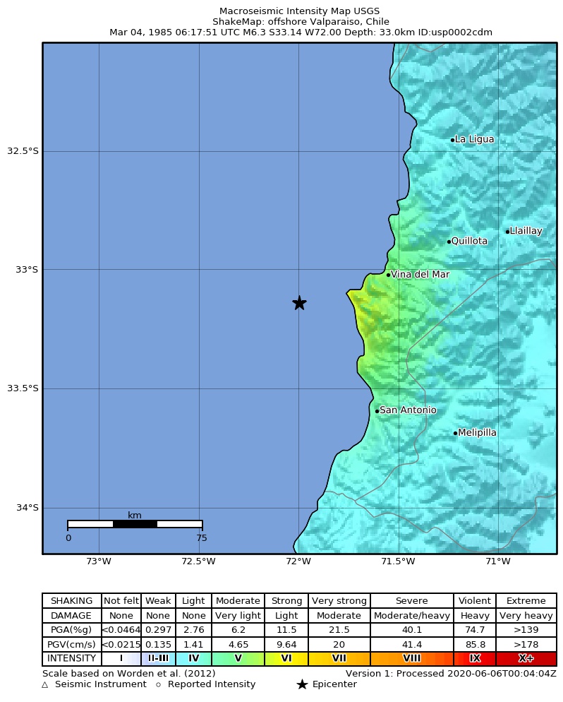
The USGS ShakeMap: shaking estimated from seismic stations and the quake’s size, on the Modified Mercalli intensity scale.
- Strongest estimated
- VI, strong shaking
- Peak ground acceleration
- 13.1% of gravity
- Peak ground velocity
- 2.1 cm/s
- Map
- Automatic
Did you feel it?
No one has reported feeling this quake to the USGS.
How well it is located
Reviewed by a seismologist.
- Depth from
- OPERATOR_ASSIGNED
Nearest places
Distance and direction from each place to the epicenter, with its forecast.
Nearby
Within 100 km, magnitude 2.5 and up: 130 in the 60 days after this one and 41 in the 30 days before it.
After
- 4.79 km WNW of Valparaíso, Chile · 15177 days ago · 33 km deep · 31 km away
- 4.77 km NNW of Quilpué, Chile · 15177 days ago · 33 km deep · 52 km away
- 4.816 km NNW of Cartagena, Chile · 15177 days ago · 33 km deep · 43 km away
- 4.626 km NNW of Cartagena, Chile · 15177 days ago · 33 km deep · 34 km away
- 4.426 km WSW of Melipilla, Chile · 15177 days ago · 33 km deep · 91 km away
- 5.118 km NW of Valparaíso, Chile · 15177 days ago · 33 km deep · 34 km away
- 4.762 km WNW of Valparaíso, Chile · 15177 days ago · 33 km deep · 45 km away
- 5.438 km WSW of Valparaíso, Chile · 15177 days ago · 33 km deep · 9 km away
- 5.772 km WSW of San Antonio, Chile · 15177 days ago · 29 km deep · 90 km away
- 4.762 km WSW of San Antonio, Chile · 15177 days ago · 33 km deep · 73 km away
- 5.466 km WSW of San Antonio, Chile · 15177 days ago · 33 km deep · 88 km away
- 6.224 km NW of Valparaíso, Chile · 15177 days ago · 33 km deep · 34 km away
- 4.416 km SW of Melipilla, Chile · 15177 days ago · 33 km deep · 94 km away
- 5.130 km W of Cartagena, Chile · 15177 days ago · 33 km deep · 45 km away
- 5.158 km SW of San Antonio, Chile · 15177 days ago · 33 km deep · 92 km away
- 3.342 km WSW of San Antonio, Chile · 15177 days ago · 33 km deep · 73 km away
- 4.478 km NW of Valparaíso, Chile · 15176 days ago · 33 km deep · 68 km away
- 3.620 km WNW of Cartagena, Chile · 15176 days ago · 33 km deep · 40 km away
- 3.227 km WNW of Hacienda La Calera, Chile · 15176 days ago · 33 km deep · 71 km away
- 3.150 km WSW of Valparaíso, Chile · 15176 days ago · 33 km deep · 15 km away
- 4.157 km WNW of Valparaíso, Chile · 15176 days ago · 33 km deep · 39 km away
- 5.283 km WSW of San Antonio, Chile · 15176 days ago · 33 km deep · 98 km away
- 4.846 km SW of San Antonio, Chile · 15176 days ago · 33 km deep · 79 km away
- 4.958 km WSW of San Antonio, Chile · 15176 days ago · 33 km deep · 78 km away
- 4.249 km NW of Valparaíso, Chile · 15176 days ago · 33 km deep · 46 km away
- 5.141 km N of Valparaíso, Chile · 15176 days ago · 33 km deep · 59 km away
- 5.163 km SW of San Antonio, Chile · 15176 days ago · 33 km deep · 91 km away
- 3.788 km WSW of San Antonio, Chile · 15176 days ago · 33 km deep · 99 km away
- 5.132 km NNW of Valparaíso, Chile · 15176 days ago · 43 km deep · 44 km away
- 4.565 km WNW of Cartagena, Chile · 15176 days ago · 33 km deep · 40 km away
- 5.125 km SSW of San Antonio, Chile · 15176 days ago · 49 km deep · 79 km away
- 4.468 km SW of San Antonio, Chile · 15176 days ago · 33 km deep · 95 km away
- 3.033 km NW of Cartagena, Chile · 15176 days ago · 33 km deep · 27 km away
- 4.036 km W of Valparaíso, Chile · 15176 days ago · 33 km deep · 15 km away
- 5.464 km WSW of Valparaíso, Chile · 15176 days ago · 33 km deep · 29 km away
- 4.251 km NNW of Valparaíso, Chile · 15175 days ago · 33 km deep · 66 km away
- 2.839 km W of Valparaíso, Chile · 15175 days ago · 33 km deep · 16 km away
- 3.312 km W of Melipilla, Chile · 15175 days ago · 33 km deep · 86 km away
- 3.97 km WSW of La Ligua, Chile · 15175 days ago · 33 km deep · 98 km away
- 4.071 km WNW of Valparaíso, Chile · 15175 days ago · 33 km deep · 44 km away
- 2.871 km W of Cartagena, Chile · 15175 days ago · 33 km deep · 52 km away
- 4.633 km W of Cartagena, Chile · 15175 days ago · 33 km deep · 46 km away
- 4.333 km SW of Valparaíso, Chile · 15175 days ago · 53 km deep · 10 km away
- 3.625 km WNW of Cartagena, Chile · 15175 days ago · 32 km deep · 37 km away
- 4.977 km W of Cartagena, Chile · 15175 days ago · 33 km deep · 52 km away
- 4.828 km WNW of Valparaíso, Chile · 15175 days ago · 33 km deep · 24 km away
- 5.529 km NW of Valparaíso, Chile · 15174 days ago · 56 km deep · 31 km away
- 5.346 km W of Valparaíso, Chile · 15174 days ago · 33 km deep · 21 km away
- 5.119 km WSW of Valparaíso, Chile · 15174 days ago · 33 km deep · 17 km away
- 5.346 km SW of San Antonio, Chile · 15174 days ago · 33 km deep · 87 km away
- 5.010 km SW of Valparaíso, Chile · 15174 days ago · 33 km deep · 28 km away
- 4.644 km NW of Valparaíso, Chile · 15174 days ago · 33 km deep · 39 km away
- 4.853 km WSW of San Antonio, Chile · 15174 days ago · 33 km deep · 80 km away
- 5.021 km W of Valparaíso, Chile · 15173 days ago · 33 km deep · 18 km away
- 4.721 km SW of Valparaíso, Chile · 15173 days ago · 33 km deep · 23 km away
- 3.179 km WNW of Valparaíso, Chile · 15173 days ago · 33 km deep · 57 km away
- 3.096 km W of Valparaíso, Chile · 15173 days ago · 33 km deep · 64 km away
- 2.878 km W of Valparaíso, Chile · 15173 days ago · 33 km deep · 44 km away
- 2.745 km SW of Valparaíso, Chile · 15173 days ago · 10 km deep · 17 km away
- 4.054 km WNW of Valparaíso, Chile · 15172 days ago · 33 km deep · 39 km away
The first 60 of 130.
Before
- 5.633 km SW of Valparaíso, Chile · 15177 days ago · 33 km deep · 12 km away
- 6.339 km SW of San Antonio, Chile · 15177 days ago · 33 km deep · 76 km away
- 6.619 km NW of Valparaíso, Chile · 15177 days ago · 33 km deep · 31 km away
- 5.243 km WSW of Valparaíso, Chile · 15177 days ago · 33 km deep · 12 km away
- 5.241 km WSW of Valparaíso, Chile · 15177 days ago · 33 km deep · 5 km away
- 5.440 km WSW of Valparaíso, Chile · 15177 days ago · 33 km deep · 4 km away
- 5.145 km WSW of Valparaíso, Chile · 15177 days ago · 33 km deep · 13 km away
- 5.365 km WSW of Valparaíso, Chile · 15177 days ago · 33 km deep · 30 km away
- 5.245 km WNW of Cartagena, Chile · 15177 days ago · 33 km deep · 25 km away
- 5.329 km W of San Antonio, Chile · 15177 days ago · 33 km deep · 49 km away
- 7.419 km S of Valparaíso, Chile · 15177 days ago · 33 km deep · 32 km away
- 5.511 km S of Valparaíso, Chile · 15177 days ago · 29 km deep · 34 km away
- 5.912 km NE of Viña del Mar, Chile · 15177 days ago · 33 km deep · 54 km away
- 6.45 km N of Hacienda La Calera, Chile · 15177 days ago · 33 km deep · 86 km away
- 8.025 km WSW of Valparaíso, Chile · 15177 days ago · 33 km deep · 12 km away
- 5.512 km SW of Valparaíso, Chile · 15177 days ago · 33 km deep · 25 km away
- 4.322 km N of Cartagena, Chile · 15179 days ago · 33 km deep · 42 km away
- 4.518 km S of Valparaíso, Chile · 15182 days ago · 60 km deep · 32 km away
- 4.521 km S of Valparaíso, Chile · 15182 days ago · 68 km deep · 35 km away
- 4.555 km WSW of Valparaíso, Chile · 15185 days ago · 33 km deep · 20 km away
Earthquakes todayChile earthquakesLive radar here
Sources
From the USGS Earthquake Hazards Program and its partner networks, event usp0002cdm (also filed as atlas19850304061751, iscgem529117). Read Tue, Sep 22, 2026, 10:08 AM UTC.