M6.3 earthquake 17 km S of Melipilla, Chile
A magnitude 6.3 earthquake struck 17 km S of Melipilla, Chile on Mon, Mar 4, 1985, 12:01 PM GMT-3 (15:01 UTC), 40 km (25 mi) below the surface.
A larger quake followed: M6.7 18 km S of Valparaíso, Chile. This one was a foreshock.
Map
Where this earthquake was located, with the others nearby. Select one for its page.
The earthquake
- Magnitude
- 6.3 (mw), strong
- Local time
- UTC
- 1985-03-04 15:01:07 UTC
- Depth
- 40.1 km (24.9 mi), shallow
- Epicenter
- 33.842° S, 71.249° W
- Region
- Chile
- Strongest shaking
- VI, strong shaking
- Tsunami flag
- No
- Status
- Reviewed by a seismologist
Shaking
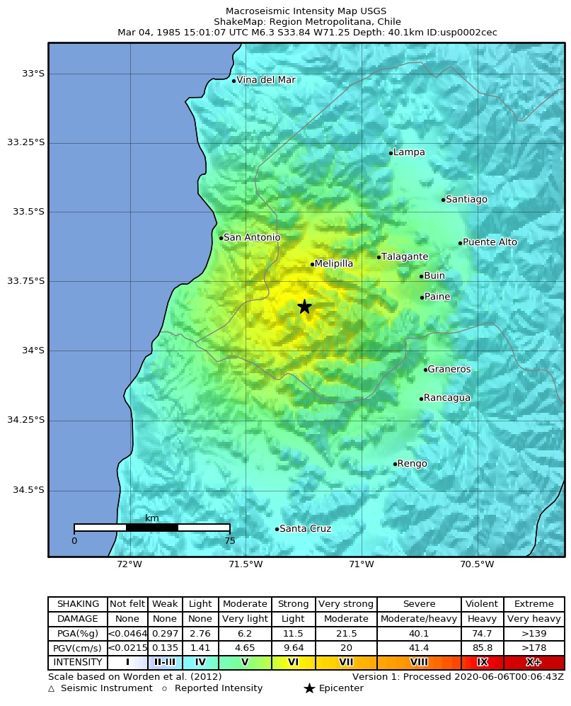
The USGS ShakeMap: shaking estimated from seismic stations and the quake’s size, on the Modified Mercalli intensity scale.
- Strongest estimated
- VI, strong shaking
- Peak ground acceleration
- 16.6% of gravity
- Peak ground velocity
- 2.2 cm/s
- Map
- Automatic
Did you feel it?
No one has reported feeling this quake to the USGS.
How well it is located
Reviewed by a seismologist.
- Depth from
- CONSTRAINED_BY_DEPTH_PHASES
Nearest places
Distance and direction from each place to the epicenter, with its forecast.
Nearby
Within 100 km, magnitude 2.5 and up: 56 in the 60 days after this one and 42 in the 30 days before it.
After
- 4.762 km WSW of San Antonio, Chile · 15177 days ago · 33 km deep · 93 km away
- 5.466 km WSW of San Antonio, Chile · 15177 days ago · 33 km deep · 89 km away
- 4.416 km SW of Melipilla, Chile · 15177 days ago · 33 km deep · 10 km away
- 5.130 km W of Cartagena, Chile · 15177 days ago · 33 km deep · 71 km away
- 5.158 km SW of San Antonio, Chile · 15177 days ago · 33 km deep · 76 km away
- 3.342 km WSW of San Antonio, Chile · 15177 days ago · 33 km deep · 70 km away
- 3.620 km WNW of Cartagena, Chile · 15177 days ago · 33 km deep · 66 km away
- 4.846 km SW of San Antonio, Chile · 15177 days ago · 33 km deep · 70 km away
- 4.958 km WSW of San Antonio, Chile · 15177 days ago · 33 km deep · 85 km away
- 5.457 km NNW of Santa Cruz, Chile · 15177 days ago · 33 km deep · 59 km away
- 5.163 km SW of San Antonio, Chile · 15177 days ago · 33 km deep · 83 km away
- 5.125 km SSW of San Antonio, Chile · 15176 days ago · 49 km deep · 42 km away
- 4.468 km SW of San Antonio, Chile · 15176 days ago · 33 km deep · 87 km away
- 3.033 km NW of Cartagena, Chile · 15176 days ago · 33 km deep · 80 km away
- 4.572 km SW of San Antonio, Chile · 15176 days ago · 33 km deep · 83 km away
- 3.312 km W of Melipilla, Chile · 15176 days ago · 33 km deep · 18 km away
- 4.062 km NW of Santa Cruz, Chile · 15176 days ago · 30 km deep · 83 km away
- 4.375 km SW of San Antonio, Chile · 15176 days ago · 33 km deep · 86 km away
- 4.633 km W of Cartagena, Chile · 15176 days ago · 33 km deep · 74 km away
- 4.333 km SW of Valparaíso, Chile · 15176 days ago · 53 km deep · 94 km away
- 3.625 km WNW of Cartagena, Chile · 15175 days ago · 32 km deep · 71 km away
- 5.346 km SW of San Antonio, Chile · 15175 days ago · 33 km deep · 62 km away
- 5.010 km SW of Valparaíso, Chile · 15175 days ago · 33 km deep · 92 km away
- 4.853 km WSW of San Antonio, Chile · 15174 days ago · 33 km deep · 78 km away
- 4.721 km SW of Valparaíso, Chile · 15173 days ago · 33 km deep · 86 km away
- 2.745 km SW of Valparaíso, Chile · 15173 days ago · 10 km deep · 94 km away
- 5.865 km W of San Antonio, Chile · 15172 days ago · 33 km deep · 99 km away
- 4.746 km WNW of Cartagena, Chile · 15172 days ago · 33 km deep · 89 km away
- 3.649 km WNW of Cartagena, Chile · 15172 days ago · 33 km deep · 95 km away
- 4.955 km WSW of San Antonio, Chile · 15172 days ago · 33 km deep · 80 km away
- 3.527 km S of Valparaíso, Chile · 15171 days ago · 66 km deep · 70 km away
- 3.041 km SW of San Antonio, Chile · 15167 days ago · 33 km deep · 67 km away
- 4.546 km SW of Valparaíso, Chile · 15166 days ago · 33 km deep · 96 km away
- 5.0near the coast of central Chile · 15163 days ago · 33 km deep · 77 km away
- 4.666 km SW of San Antonio, Chile · 15163 days ago · 33 km deep · 83 km away
- 6.718 km S of Valparaíso, Chile · 15163 days ago · 42 km deep · 81 km away
- 5.012 km SW of Valparaíso, Chile · 15163 days ago · 58 km deep · 94 km away
- 4.738 km WNW of Cartagena, Chile · 15162 days ago · 33 km deep · 84 km away
- 5.223 km NW of Cartagena, Chile · 15162 days ago · 33 km deep · 69 km away
- 5.776 km NW of Santa Cruz, Chile · 15159 days ago · 57 km deep · 82 km away
- 6.586 km WNW of Santa Cruz, Chile · 15157 days ago · 45 km deep · 98 km away
- 4.280 km SW of San Antonio, Chile · 15156 days ago · 10 km deep · 95 km away
- 4.680 km WNW of Santa Cruz, Chile · 15153 days ago · 33 km deep · 91 km away
- 7.259 km S of San Antonio, Chile · 15142 days ago · 38 km deep · 47 km away
- 4.274 km WSW of San Antonio, Chile · 15141 days ago · 33 km deep · 97 km away
- 3.010 km N of Cartagena, Chile · 15140 days ago · 33 km deep · 55 km away
- 4.066 km SW of San Antonio, Chile · 15140 days ago · 33 km deep · 88 km away
- 3.272 km WSW of San Antonio, Chile · 15139 days ago · 33 km deep · 94 km away
- 3.379 km SW of San Antonio, Chile · 15138 days ago · 33 km deep · 99 km away
- 4.855 km SW of San Antonio, Chile · 15137 days ago · 33 km deep · 72 km away
- 5.633 km WNW of Cartagena, Chile · 15136 days ago · 33 km deep · 77 km away
- 4.562 km W of San Antonio, Chile · 15136 days ago · 33 km deep · 98 km away
- 4.571 km SW of San Antonio, Chile · 15136 days ago · 33 km deep · 87 km away
- 4.664 km W of San Antonio, Chile · 15129 days ago · 33 km deep · 99 km away
- 4.342 km WSW of San Antonio, Chile · 15129 days ago · 33 km deep · 69 km away
- 4.359 km W of Cartagena, Chile · 15129 days ago · 33 km deep · 100 km away
Before
- 5.772 km WSW of San Antonio, Chile · 15178 days ago · 29 km deep · 96 km away
- 5.438 km WSW of Valparaíso, Chile · 15178 days ago · 33 km deep · 96 km away
- 4.426 km WSW of Melipilla, Chile · 15178 days ago · 33 km deep · 19 km away
- 4.626 km NNW of Cartagena, Chile · 15178 days ago · 33 km deep · 71 km away
- 4.816 km NNW of Cartagena, Chile · 15178 days ago · 33 km deep · 62 km away
- 5.148 km S of San Antonio, Chile · 15178 days ago · 33 km deep · 44 km away
- 4.77 km NNW of Quilpué, Chile · 15178 days ago · 33 km deep · 98 km away
- 4.779 km WNW of Santa Cruz, Chile · 15178 days ago · 33 km deep · 93 km away
- 5.053 km SSW of San Antonio, Chile · 15178 days ago · 33 km deep · 54 km away
- 4.866 km SSW of San Antonio, Chile · 15178 days ago · 33 km deep · 69 km away
- 5.633 km SW of Valparaíso, Chile · 15178 days ago · 33 km deep · 93 km away
- 6.339 km SW of San Antonio, Chile · 15178 days ago · 33 km deep · 63 km away
- 6.263 km SSW of San Antonio, Chile · 15178 days ago · 33 km deep · 68 km away
- 5.179 km WNW of Santa Cruz, Chile · 15178 days ago · 33 km deep · 90 km away
- 5.243 km WSW of Valparaíso, Chile · 15178 days ago · 33 km deep · 98 km away
- 4.954 km SSW of San Antonio, Chile · 15178 days ago · 33 km deep · 55 km away
- 5.145 km WSW of Valparaíso, Chile · 15178 days ago · 33 km deep · 99 km away
- 5.245 km WNW of Cartagena, Chile · 15178 days ago · 33 km deep · 91 km away
- 5.329 km W of San Antonio, Chile · 15178 days ago · 33 km deep · 69 km away
- 7.419 km S of Valparaíso, Chile · 15178 days ago · 33 km deep · 80 km away
Earthquakes todayChile earthquakesLive radar here
Sources
From the USGS Earthquake Hazards Program and its partner networks, event usp0002cec (also filed as choy19850304150109, gcmtb030485d, gcmt19850304150106, atlas19850304150113, iscgem529154). Read Wed, Sep 23, 2026, 2:18 AM UTC.