M5.4 earthquake 22 km SSW of Three Rocks, California
A magnitude 5.4 earthquake struck 22 km SSW of Three Rocks, California on Mon, Oct 25, 1982, 3:26 PM PDT (22:26 UTC), 11 km (7 mi) below the surface.
Map
Where this earthquake was located, with the others nearby. Select one for its page.
The earthquake
- Magnitude
- 5.4 (ml), moderate
- Local time
- UTC
- 1982-10-25 22:26:03 UTC
- Depth
- 11.4 km (7.1 mi), shallow
- Epicenter
- 36.320° N, 120.506° W
- Region
- California
- Strongest shaking
- VI, strong shaking
- Tsunami flag
- No
- Status
- Reviewed by a seismologist
Shaking
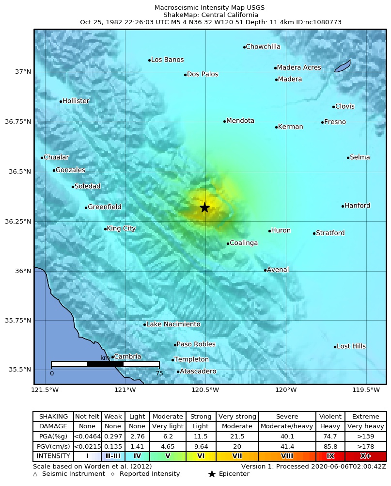
The USGS ShakeMap: shaking estimated from seismic stations and the quake’s size, on the Modified Mercalli intensity scale.
- Strongest estimated
- VI, strong shaking
- Peak ground acceleration
- 21.2% of gravity
- Peak ground velocity
- 2.3 cm/s
- Map
- Automatic
Did you feel it?
No one has reported feeling this quake to the USGS.
How well it is located
Reviewed by a seismologist.
- Location uncertainty
- About 0.3 km horizontally, 0.5 km in depth
- Depth from
- From location
- Station coverage gap
- 88°
- Stations used
- 68
Nearest places
Distance and direction from each place to the epicenter, with its forecast.
Nearby
Within 100 km, magnitude 2.4 and up: 34 in the 60 days after this one and 12 in the 30 days before it.
After
- 3.922 km NW of Coalinga, California · 16038 days ago · 18 km deep · 2 km away
- 2.5Central California · 16038 days ago · 10 km deep · 2 km away
- 2.523 km NW of Coalinga, California · 16038 days ago · 10 km deep · 3 km away
- 3.023 km NW of Coalinga, California · 16038 days ago · 9 km deep · 3 km away
- 2.621 km SSW of Three Rocks, California · 16038 days ago · 10 km deep · 1 km away
- 4.221 km SSW of Three Rocks, California · 16038 days ago · 5 km deep · 1 km away
- 4.022 km SSW of Three Rocks, California · 16038 days ago · 11 km deep · 1 km away
- 3.423 km SSW of Three Rocks, California · 16038 days ago · 11 km deep · 1 km away
- 3.524km N of Coalinga, CA · 16038 days ago · 5 km deep · 10 km away
- 3.022 km NW of Coalinga, California · 16038 days ago · 10 km deep · 1 km away
- 2.422 km SSW of Three Rocks, California · 16038 days ago · 10 km deep · 1 km away
- 2.521 km NW of Coalinga, California · 16038 days ago · 10 km deep · 3 km away
- 2.422 km SSW of Three Rocks, California · 16038 days ago · 11 km deep · 1 km away
- 2.924 km NW of Coalinga, California · 16037 days ago · 10 km deep · 4 km away
- 3.122 km NW of Coalinga, California · 16037 days ago · 10 km deep · 2 km away
- 2.823 km SSW of Three Rocks, California · 16037 days ago · 11 km deep · 2 km away
- 3.221 km SSW of Three Rocks, California · 16036 days ago · 11 km deep · 1 km away
- 2.824 km NW of Coalinga, California · 16035 days ago · 9 km deep · 3 km away
- 2.922 km NE of Soledad, California · 16035 days ago · 8 km deep · 62 km away
- 3.021 km SSW of Three Rocks, California · 16035 days ago · 11 km deep · 2 km away
- 2.622 km SSW of Three Rocks, California · 16034 days ago · 10 km deep · 2 km away
- 2.424 km NW of Coalinga, California · 16034 days ago · 6 km deep · 5 km away
- 2.423 km NW of Coalinga, California · 16032 days ago · 7 km deep · 4 km away
- 2.422 km NE of Soledad, California · 16032 days ago · 7 km deep · 67 km away
- 2.421 km NE of Soledad, California · 16028 days ago · 6 km deep · 62 km away
- 2.424 km NW of Parkfield, California · 16026 days ago · 5 km deep · 31 km away
- 2.615 km SSE of Tres Pinos, California · 16020 days ago · 8 km deep · 78 km away
- 3.716 km ESE of Tres Pinos, California · 16019 days ago · 8 km deep · 74 km away
- 3.18 km SSW of Tres Pinos, California · 15994 days ago · 3 km deep · 89 km away
- 2.521 km NE of Soledad, California · 15991 days ago · 7 km deep · 63 km away
- 2.62 km WNW of Parkfield, California · 15989 days ago · 6 km deep · 46 km away
- 2.511 km S of Tres Pinos, California · 15986 days ago · 6 km deep · 82 km away
- 3.06 km SSE of Parkfield, California · 15984 days ago · 6 km deep · 54 km away
- 3.11 km SSE of Parkfield, California · 15979 days ago · 5 km deep · 49 km away
Before
- 3.023 km NW of Coalinga, California · 16038 days ago · 9 km deep · 1 km away
- 3.018 km SSE of Tres Pinos, California · 16039 days ago · 9 km deep · 75 km away
- 2.814 km SSE of Tres Pinos, California · 16042 days ago · 8 km deep · 79 km away
- 3.122 km NNE of Soledad, California · 16042 days ago · 6 km deep · 70 km away
- 3.015 km SSE of Tres Pinos, California · 16046 days ago · 8 km deep · 79 km away
- 3.114 km SSE of Tres Pinos, California · 16046 days ago · 8 km deep · 79 km away
- 2.614 km SSE of Tres Pinos, California · 16046 days ago · 8 km deep · 79 km away
- 3.315 km SSE of Tres Pinos, California · 16047 days ago · 8 km deep · 79 km away
- 3.023 km ENE of San Lucas, California · 16052 days ago · 8 km deep · 28 km away
- 2.420 km NW of Parkfield, California · 16056 days ago · 7 km deep · 32 km away
- 2.524 km NE of Greenfield, California · 16064 days ago · 5 km deep · 51 km away
- 2.924 km S of Kettleman City, California · 16066 days ago · 9 km deep · 74 km away
Earthquakes todayCalifornia earthquakesLive radar here
Sources
From the USGS Earthquake Hazards Program and its partner networks, event nc1080773 (also filed as gcmtb102582b, ushis3767, usp0001qh3, gcmt19821025222604, iscgem591044, ci509322). Read Tue, Sep 22, 2026, 11:33 PM UTC.