M4.7 earthquake 9 km NW of Ulcinj, Montenegro
A magnitude 4.7 earthquake struck 9 km NW of Ulcinj, Montenegro on Mon, May 14, 1979, 10:53 AM GMT+1 (09:53 UTC), 10 km (6 mi) below the surface.
A larger quake followed: M6.2 8 km WSW of Budva, Montenegro. This one was a foreshock.
Map
Where this earthquake was located, with the others nearby. Select one for its page.
The earthquake
- Magnitude
- 4.7 (mb), light
- Local time
- UTC
- 1979-05-14 09:53:07 UTC
- Depth
- 10.0 km (6.2 mi), shallow
- Epicenter
- 41.979° N, 19.132° E
- Region
- Montenegro
- Strongest shaking
- V, moderate shaking
- Tsunami flag
- No
- Status
- Reviewed by a seismologist
Shaking
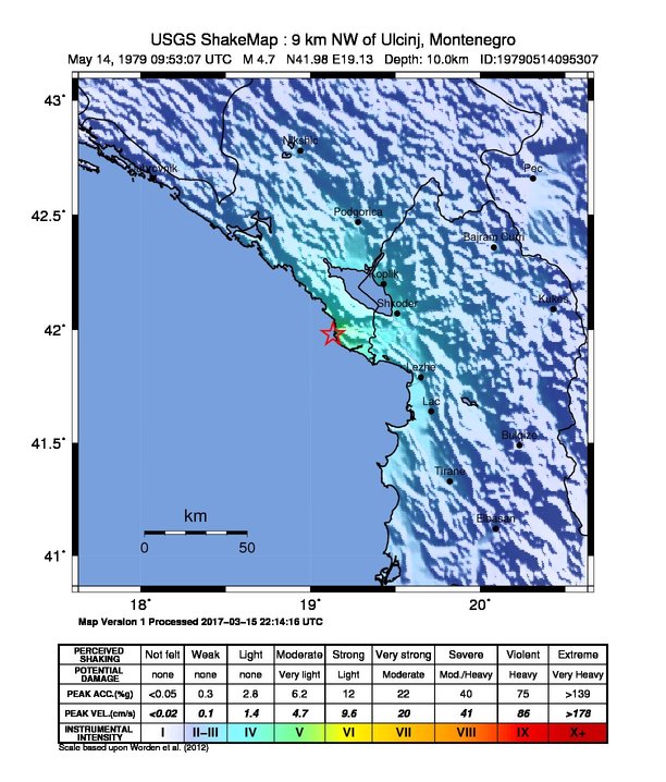
The USGS ShakeMap: shaking estimated from seismic stations and the quake’s size, on the Modified Mercalli intensity scale.
- Strongest estimated
- V, moderate shaking
- Map
- Automatic
Did you feel it?
No one has reported feeling this quake to the USGS.
How well it is located
Reviewed by a seismologist.
- Depth from
- OPERATOR_ASSIGNED
- Stations used
- 102
Nearest places
Distance and direction from each place to the epicenter, with its forecast.
Nearby
Within 100 km, magnitude 1.7 and up: 65 in the 60 days after this one and 99 in the 30 days before it.
After
- 3.14 km SSW of Ulcinj, Montenegro · 17296 days ago · 10 km deep · 11 km away
- 3.37 km W of Shëngjin, Albania · 17296 days ago · 10 km deep · 36 km away
- 3.610 km E of Stari Bar, Montenegro · 17294 days ago · 10 km deep · 18 km away
- 4.214 km WSW of Budva, Montenegro · 17292 days ago · 10 km deep · 47 km away
- 3.77 km SSW of Budva, Montenegro · 17292 days ago · 10 km deep · 37 km away
- 3.315 km ESE of Ulcinj, Montenegro · 17290 days ago · 10 km deep · 25 km away
- 3.59 km SE of Vukatanë, Albania · 17289 days ago · 10 km deep · 41 km away
- 3.610 km N of Ulcinj, Montenegro · 17288 days ago · 10 km deep · 10 km away
- 6.28 km WSW of Budva, Montenegro · 17288 days ago · 8 km deep · 44 km away
- 3.226 km SW of Petrovac na Moru, Montenegro · 17288 days ago · 10 km deep · 37 km away
- 3.67 km WNW of Budva, Montenegro · 17288 days ago · 10 km deep · 48 km away
- 3.74 km ESE of Budva, Montenegro · 17288 days ago · 10 km deep · 37 km away
- 3.55 km SSW of Budva, Montenegro · 17288 days ago · 10 km deep · 38 km away
- 3.911 km WSW of Budva, Montenegro · 17288 days ago · 10 km deep · 45 km away
- 3.75 km NE of Petrovac na Moru, Montenegro · 17288 days ago · 10 km deep · 32 km away
- 5.16 km W of Petrovac na Moru, Montenegro · 17288 days ago · 10 km deep · 34 km away
- 3.810 km SW of Budva, Montenegro · 17288 days ago · 10 km deep · 40 km away
- 3.914 km WSW of Budva, Montenegro · 17288 days ago · 10 km deep · 46 km away
- 3.66 km WNW of Petrovac na Moru, Montenegro · 17288 days ago · 10 km deep · 35 km away
- 3.917 km SW of Budva, Montenegro · 17287 days ago · 10 km deep · 46 km away
- 3.711 km SSW of Budva, Montenegro · 17287 days ago · 10 km deep · 36 km away
- 4.48 km SW of Budva, Montenegro · 17287 days ago · 10 km deep · 42 km away
- 3.421 km SW of Budva, Montenegro · 17287 days ago · 10 km deep · 45 km away
- 3.520 km SW of Budva, Montenegro · 17287 days ago · 10 km deep · 44 km away
- 3.412 km SW of Budva, Montenegro · 17287 days ago · 10 km deep · 40 km away
- 4.513 km SSW of Budva, Montenegro · 17287 days ago · 10 km deep · 37 km away
- 3.618 km SW of Petrovac na Moru, Montenegro · 17287 days ago · 10 km deep · 30 km away
- 3.810 km SW of Budva, Montenegro · 17287 days ago · 10 km deep · 40 km away
- 3.715 km WSW of Budva, Montenegro · 17287 days ago · 10 km deep · 49 km away
- 3.87 km NW of Budva, Montenegro · 17286 days ago · 10 km deep · 50 km away
- 3.215 km SW of Nikši?, Montenegro · 17286 days ago · 10 km deep · 84 km away
- 3.016 km W of Budva, Montenegro · 17285 days ago · 10 km deep · 53 km away
- 3.39 km SW of Budva, Montenegro · 17285 days ago · 10 km deep · 42 km away
- 4.210 km SW of Budva, Montenegro · 17285 days ago · 10 km deep · 39 km away
- 4.212 km SW of Budva, Montenegro · 17284 days ago · 10 km deep · 41 km away
- 3.27 km SSW of Ulcinj, Montenegro · 17284 days ago · 10 km deep · 12 km away
- 3.411 km W of Ulcinj, Montenegro · 17283 days ago · 10 km deep · 7 km away
- 3.98 km SW of Budva, Montenegro · 17283 days ago · 10 km deep · 40 km away
- 4.317 km W of Ulcinj, Montenegro · 17282 days ago · 10 km deep · 13 km away
- 3.814 km SW of Budva, Montenegro · 17282 days ago · 10 km deep · 42 km away
- 3.515 km SW of Budva, Montenegro · 17282 days ago · 10 km deep · 40 km away
- 4.15 km NW of Budva, Montenegro · 17282 days ago · 10 km deep · 47 km away
- 3.418 km SE of Ulcinj, Montenegro · 17280 days ago · 10 km deep · 27 km away
- 4.815 km SSW of Tivat, Montenegro · 17280 days ago · 10 km deep · 57 km away
- 3.71 km WNW of Ulcinj, Montenegro · 17279 days ago · 10 km deep · 8 km away
- 4.515 km SSW of Tivat, Montenegro · 17278 days ago · 10 km deep · 55 km away
- 4.517 km WSW of Petrovac na Moru, Montenegro · 17277 days ago · 10 km deep · 34 km away
- 3.413 km WSW of Petrovac na Moru, Montenegro · 17277 days ago · 10 km deep · 33 km away
- 4.16 km W of Budva, Montenegro · 17276 days ago · 10 km deep · 46 km away
- 4.818 km SW of Budva, Montenegro · 17275 days ago · 10 km deep · 43 km away
- 3.219 km SSE of Ulcinj, Montenegro · 17275 days ago · 10 km deep · 28 km away
- 2.711 km WSW of Ulcinj, Montenegro · 17270 days ago · 10 km deep · 12 km away
- 3.324 km SW of Budva, Montenegro · 17270 days ago · 10 km deep · 44 km away
- 3.212 km SW of Budva, Montenegro · 17270 days ago · 10 km deep · 40 km away
- 3.67 km S of Budva, Montenegro · 17268 days ago · 10 km deep · 36 km away
- 4.214 km SSW of Tivat, Montenegro · 17266 days ago · 10 km deep · 58 km away
- 4.517 km WSW of Budva, Montenegro · 17263 days ago · 10 km deep · 47 km away
- 3.012 km SW of Ulcinj, Montenegro · 17263 days ago · 10 km deep · 13 km away
- 4.716 km SW of Budva, Montenegro · 17261 days ago · 10 km deep · 41 km away
- 3.616 km W of Budva, Montenegro · 17256 days ago · 10 km deep · 53 km away
The first 60 of 65.
Before
- 3.68 km W of Shëngjin, Albania · 17300 days ago · 10 km deep · 35 km away
- 3.49 km WNW of Ulcinj, Montenegro · 17300 days ago · 10 km deep · 3 km away
- 4.98 km NW of Budva, Montenegro · 17300 days ago · 10 km deep · 50 km away
- 3.4Albania · 17301 days ago · 10 km deep · 8 km away
- 3.88 km SSE of Stari Bar, Montenegro · 17301 days ago · 10 km deep · 6 km away
- 3.5Croatia-Bosnia-Montenegro border region · 17301 days ago · 10 km deep · 38 km away
- 3.22 km SW of Ulcinj, Montenegro · 17302 days ago · 10 km deep · 10 km away
- 3.26 km E of Ulcinj, Montenegro · 17302 days ago · 10 km deep · 15 km away
- 3.42 km SSW of Herceg Novi, Montenegro · 17302 days ago · 10 km deep · 71 km away
- 3.423 km N of Durrës, Albania · 17303 days ago · 10 km deep · 55 km away
- 2.93 km W of Ulcinj, Montenegro · 17303 days ago · 10 km deep · 7 km away
- 3.311 km SE of Ulcinj, Montenegro · 17303 days ago · 10 km deep · 21 km away
- 3.59 km SSE of Stari Bar, Montenegro · 17303 days ago · 10 km deep · 7 km away
- 3.414 km WSW of Budva, Montenegro · 17305 days ago · 10 km deep · 47 km away
- 3.213 km ESE of Ulcinj, Montenegro · 17306 days ago · 10 km deep · 23 km away
- 3.323 km SW of Sutomore, Montenegro · 17306 days ago · 10 km deep · 26 km away
- 3.315 km SSW of Petrovac na Moru, Montenegro · 17306 days ago · 10 km deep · 23 km away
- 3.85 km NW of Ulcinj, Montenegro · 17309 days ago · 10 km deep · 4 km away
- 3.29 km SSW of Ulcinj, Montenegro · 17311 days ago · 10 km deep · 15 km away
- 4.7Croatia-Bosnia-Montenegro border region · 17312 days ago · 10 km deep · 43 km away
Earthquakes todayMontenegro earthquakesLive radar here
Sources
From the USGS Earthquake Hazards Program and its partner networks, event usp00010n2 (also filed as iscgem665073, iscgemsup665073, atlas19790514095307). Read Tue, Sep 22, 2026, 12:16 PM UTC.