M5.2 earthquake 13 km WNW of Samoa, California
A magnitude 5.2 earthquake struck 13 km WNW of Samoa, California on Sat, Feb 3, 1979, 1:58 AM PST (09:58 UTC), 24 km (15 mi) below the surface.
Map
Where this earthquake was located, with the others nearby. Select one for its page.
The earthquake
- Magnitude
- 5.2 (ml), moderate
- Local time
- UTC
- 1979-02-03 09:58:16 UTC
- Depth
- 23.6 km (14.7 mi), shallow
- Epicenter
- 40.874° N, 124.325° W
- Region
- California
- Strongest shaking
- V, moderate shaking
- Tsunami flag
- No
- Status
- Reviewed by a seismologist
Shaking
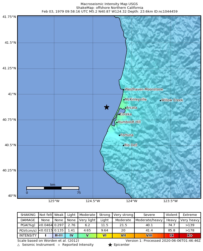
The USGS ShakeMap: shaking estimated from seismic stations and the quake’s size, on the Modified Mercalli intensity scale.
- Strongest estimated
- V, moderate shaking
- Peak ground acceleration
- 7.5% of gravity
- Peak ground velocity
- 1.3 cm/s
- Map
- Automatic
Did you feel it?
No one has reported feeling this quake to the USGS.
How well it is located
Reviewed by a seismologist.
- Location uncertainty
- About 1.4 km horizontally, 0.9 km in depth
- Depth from
- From location
- Station coverage gap
- 236°, poorly surrounded by stations
- Stations used
- 15
Nearest places
Distance and direction from each place to the epicenter, with its forecast.
Nearby
Within 100 km, magnitude 2.2 and up: 42 in the 60 days after this one and 25 in the 30 days before it.
After
- 3.511 km WNW of Samoa, California · 17398 days ago · 23 km deep · 2 km away
- 2.712 km WNW of Samoa, California · 17398 days ago · 22 km deep · 1 km away
- 2.211 km WNW of Samoa, California · 17398 days ago · 23 km deep · 2 km away
- 2.712 km WNW of Samoa, California · 17398 days ago · 23 km deep · 1 km away
- 2.33 km W of Samoa, California · 17398 days ago · 23 km deep · 10 km away
- 2.3near the coast of Northern California · 17398 days ago · 21 km deep · 4 km away
- 2.4near the coast of Northern California · 17398 days ago · 25 km deep · 5 km away
- 2.412 km WNW of Samoa, California · 17398 days ago · 23 km deep · 1 km away
- 2.812 km WNW of Samoa, California · 17397 days ago · 23 km deep · 1 km away
- 2.912 km WNW of Samoa, California · 17397 days ago · 23 km deep · 1 km away
- 2.65 km ESE of Pine Hills, California · 17395 days ago · 23 km deep · 26 km away
- 2.811 km WNW of Samoa, California · 17395 days ago · 23 km deep · 2 km away
- 2.277 km WSW of Ferndale, California · 17391 days ago · 4 km deep · 88 km away
- 2.497 km W of Trinidad, California · 17390 days ago · 5 km deep · 86 km away
- 2.912 km WNW of Samoa, California · 17388 days ago · 24 km deep · 1 km away
- 2.327 km WNW of Shelter Cove, California · 17388 days ago · 24 km deep · 87 km away
- 2.59 km NE of Myers Flat, California · 17387 days ago · 20 km deep · 76 km away
- 2.619 km SW of Scotia, California · 17386 days ago · 30 km deep · 55 km away
- 2.632 km WSW of Ferndale, California · 17385 days ago · 26 km deep · 54 km away
- 2.791 km WNW of Indianola, California · 17384 days ago · 6 km deep · 81 km away
- 2.837 km SW of Ferndale, California · 17381 days ago · 23 km deep · 65 km away
- 2.332 km SW of Scotia, California · 17380 days ago · 22 km deep · 66 km away
- 2.736 km SW of Ferndale, California · 17373 days ago · 22 km deep · 65 km away
- 2.335 km SSW of Ferndale, California · 17371 days ago · 21 km deep · 65 km away
- 2.936 km SSW of Ferndale, California · 17368 days ago · 22 km deep · 66 km away
- 3.435 km SSW of Ferndale, California · 17368 days ago · 22 km deep · 65 km away
- 3.036 km SW of Ferndale, California · 17367 days ago · 23 km deep · 65 km away
- 2.388 km W of Trinidad, California · 17366 days ago · 5 km deep · 76 km away
- 3.528 km WSW of Ferndale, California · 17366 days ago · 23 km deep · 51 km away
- 2.458 km W of Trinidad, California · 17364 days ago · 3 km deep · 49 km away
- 3.123 km SW of Ferndale, California · 17363 days ago · 23 km deep · 52 km away
- 2.730 km SW of Ferndale, California · 17363 days ago · 24 km deep · 58 km away
- 2.432 km SW of Scotia, California · 17357 days ago · 21 km deep · 66 km away
- 3.331 km SW of Ferndale, California · 17355 days ago · 26 km deep · 57 km away
- 3.536 km NW of Shelter Cove, California · 17355 days ago · 5 km deep · 74 km away
- 4.142 km SW of Ferndale, California · 17355 days ago · 15 km deep · 67 km away
- 3.679 km W of Trinidad, California · 17354 days ago · 40 km deep · 67 km away
- 2.225 km SW of Scotia, California · 17354 days ago · 22 km deep · 58 km away
- 3.145 km SW of Ferndale, California · 17351 days ago · 19 km deep · 68 km away
- 4.2102 km W of Big Lagoon, California · 17351 days ago · 4 km deep · 95 km away
- 3.035 km SSW of Ferndale, California · 17349 days ago · 21 km deep · 66 km away
- 3.441 km W of Samoa, California · 17348 days ago · 19 km deep · 30 km away
Before
- 3.534 km SW of Scotia, California · 17399 days ago · 22 km deep · 65 km away
- 3.325 km SSW of Ferndale, California · 17399 days ago · 19 km deep · 56 km away
- 3.516 km ENE of Westhaven-Moonstone, California · 17406 days ago · 22 km deep · 43 km away
- 2.517 km N of Willow Creek, California · 17406 days ago · 29 km deep · 65 km away
- 3.3off the coast of Northern California · 17406 days ago · 41 km deep · 86 km away
- 2.391 km W of Big Lagoon, California · 17408 days ago · 5 km deep · 82 km away
- 2.410 km ENE of Hydesville, California · 17408 days ago · 21 km deep · 42 km away
- 2.326 km WNW of Ferndale, California · 17408 days ago · 22 km deep · 32 km away
- 3.428 km WNW of Ferndale, California · 17408 days ago · 22 km deep · 31 km away
- 2.8101 km WNW of Ferndale, California · 17409 days ago · 4 km deep · 93 km away
- 2.33 km NNW of Redway, California · 17409 days ago · 18 km deep · 90 km away
- 2.33 km NNW of Redway, California · 17410 days ago · 19 km deep · 91 km away
- 2.675 km WSW of Ferndale, California · 17411 days ago · 25 km deep · 86 km away
- 2.785 km W of Big Lagoon, California · 17417 days ago · 6 km deep · 77 km away
- 2.54 km NE of Hydesville, California · 17418 days ago · 3 km deep · 39 km away
- 2.410 km NW of Fields Landing, California · 17420 days ago · 24 km deep · 11 km away
- 2.485 km W of Big Lagoon, California · 17421 days ago · 2 km deep · 80 km away
- 2.32 km WSW of Loleta, California · 17421 days ago · 18 km deep · 28 km away
- 2.927 km SW of Ferndale, California · 17422 days ago · 19 km deep · 56 km away
- 2.79 km SSW of Ferndale, California · 17422 days ago · 23 km deep · 43 km away
Earthquakes todayCalifornia earthquakesLive radar here
Sources
From the USGS Earthquake Hazards Program and its partner networks, event nc1044459 (also filed as ushis3504, usp0000ypq). Read Tue, Sep 22, 2026, 7:07 AM UTC.